


 |
|
 |
Expedition Data:
Duration of expedition: 40 days (June - July 2000)
Road traveled: 7016 km (4,359 miles)
Surveyed provinces: Istanbul, Kirklareli, Tekirdag, Edirne, Çanakkale, Balikesir, Bursa, Bilecik, Yalova,
Sakarya, Kocaeli
Recorded visual data: 1224 shots of analog photograph, 825 shots of digital photograph (480 Mb), 21 hours of video
Archaeological Data:
Archaeological periods surveyed: Palaeolithic/Epipalaeolithic, Neolithic, Chalcolithic and Early Bronze Age.
Number of target settlements: 202
Distribution of archaeological periods over target settlements: Palaeolithic/Epipalaeolithic: 15, Neolithic: 12, Chalcolithic: 30, EBA: 103, Neolithic + Chalcolithic: 1, Chalcolithic + EBA: 22, Neolithic + Chalcolithic + EBA: 4, Neolithic + EBA: 4, Other: 11
Distribution of settlement types over target sites: Mounds: 110, Flat settlements: 33, Habitation sites/Ateliers: 9, Cemeteries: 8, Artifact scatters: 7, Slope settlements: 5, Single find-spots: 5, Tumuli: 4, Caves: 3, Megaliths: 1, Other: 17
Number of sites not visited: 13 (Sites in military zones; completely demolished sites; sites presented just by name in publications)
Number of sites not documented: 13 (Sites with scarce description of location; sites utterly destructed by agriculture or by contemporary settlements)
Number of documented sites: 176
Destruction Data:
Number of documented sites subject to destruction: 160
Distribution of types of destruction over documented sites: Agriculture: 102, Contemporary settlements: 16, Illicit digging/treasure hunting: 9, Highways, roads, bridges etc.: 6, Natural causes: 3, Mines/quarries: 3, Other: 21
Types and description of destruction by district:
Eastern Thrace: Most common occurrences of archaeological destruction in this district are due to cultivation and other agricultural activities. Destruction caused by highways and country roads passing through or over the sites is also quite widespread. Destruction due to settlement invasion is observed primarily along the coastal areas such as Tekirdag and Gelibolu. Also, in some cases villages, village cemeteries and water depots can be found directly upon the mounds. Nevertheless, illicit digging does not appear as a significant cause of destruction in this area.
Southern Marmara: As is the case in Thrace, agricultural activity appears to be the major course of destruction of archaeological sites here as well. Specifically, leveling of fields for cultivation and construction of irrigation channels play a predominant role. Illicit digging is also a significant occurrence, for smuggling ancient artifacts is a somewhat “traditional” economic resource for several local villages in this district.
Northern Marmara: Contemporary settlement activities appear as the primary cause of destruction of archaeological sites and remains in this district. Agricultural activity and illicit digging, although not as frequently observed as in Southern Marmara also play a significant role.
|
|
|
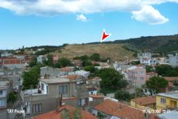
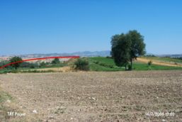
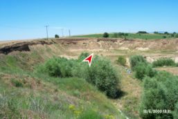
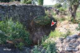
Samples from Visual Documentation of Destruction
|
|
|
 |
Akbas (mound): c. 5,000 to 7,000 years old. Mound soil is completely removed and used as filler material during the construction of the nearby highway. A military cemetery lies on one slope, while a pine grove and cultivated fields cover the rest of the grounds. There is no visible evidence of the mound anymore. |
 |
Anzavurtepe (mound): c. 9,000 years old. Most of its soil is removed and its surface is terraced for agriculture. Any surviving archaeological deposits have slid down to the skirts. A road curves along the slopes and the top of the mound hill while a petrol station sits on top of what probably was the Neolithic Age settlements. The mound bears scars of massive illicit digging. |
 |
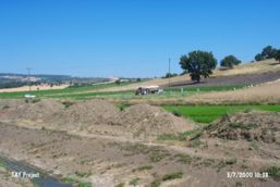
Arpalik Tepe (mound): c. 5,000 years old EBA mound. The mound is completely leveled and buried beneath a rice field. Only less than a quarter of its soil deposit is left due to soil removal. |
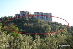 |
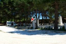
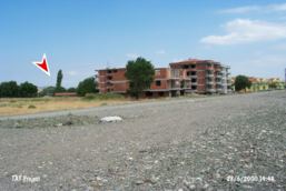
Bardakcitepe (mound): c. 7,000 years old. This site was once under protection as an officially certified primary archaeological site. Recently the status of this mound has been downgraded so as to permit construction. Now, thirteen apartment buildings, each 6-story high ornate this mound. |
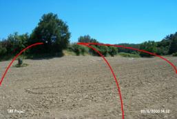 |
Bastepe (mound): c. 7,000 years old. The surface of this quite large mound is terraced for cultivation, displacing the archaeological strata. All stone remains are removed. The current landowner has recently shaved off another 3 to 5 meters off the top of what had remained. |
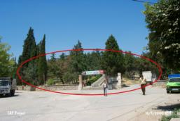 |
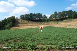
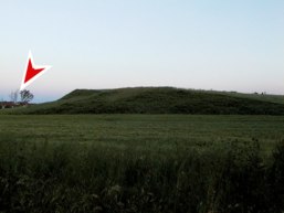
Bostin Bos Tepe (mound): c. 5,000 years old EBA mound. A public recreational area complete with kiosks, a café, and a cascading water fall feeding into a pond is what occupy the tree laden hill which was once the mound. |
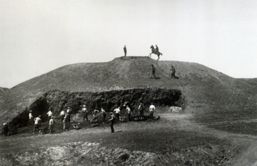 |
Bozoyuk-I (1895-96): c. 5,000 years old EBA mound. Published by A. Korte. Dimensions of the mound: 40 x 11 m. (From “Demircihuyuk” Excavation Final Publication) |
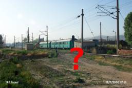 |
Bozoyuk-I (2000): Now replaced by Bozoyuk Train Station, its name still lives on though... |
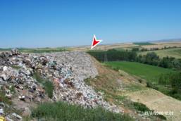 |
Cardakalti (mound): c. 5,000 years old EBA mound covered by the city dump of Edirne. It is impossible to locate the site exactly. |
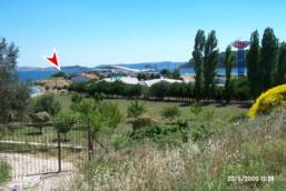 |
Degirmenlik Mevkii (mound): c. 9,000 years old. This mound, completely leveled, lies within the private grounds of Anati Bosfor Mussel Processing Plant. |
 |
Gevgililer Tumulusleri (tumulus): c. 3,000 years old tumuli. Half of this tumulus is demolished to build an irrigation channel. |
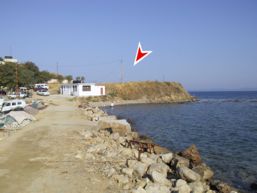 |
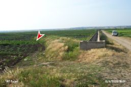
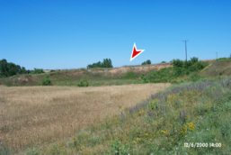
Guneyli Limani (mound): c. 5,000 years old EBA mound. The entire mound is leveled and a parking lot is built on top. |
 |
Hanay Tepe (mound): c. 5,000 years old EBA settlement. First, excavation using dated methods by Schliemann then, massive soil removal for agricultural purposes have left this mound totally disfigured. Only three relatively higher grounds on the western, southern and southeastern corners of the site have survived the onslaught. |
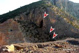 |
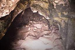
Inbogazi Magaralari (cave): These c. 7,000 years old cave settlements located in Inbogazi valley are about to be flooded by the Havran Dam being built on Gelinderesi river. |
 |
Inegol I/Cumatepe (mound): c. 5 000 years old EBA mound. Situated right in the town center of Inegol, the mound (currently utilized as a waste dump) is surrounded by a street, the municipality and two apartment buildings which are built partially on the mound. |
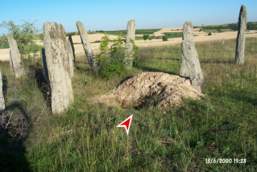 |
Kirikkoy Megalitleri (megaliths): c. 3,000 years old. Surrounding cultivated fields are about to engulf the entire site so much so that only the central megaliths are left standing. This site is subject to relentless illicit digging. |
 |
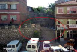
Kilisetepe (mound): Chalcolithic Age mound located atop a hill stands in the middle of a populated quarter of a modern town. There is not a trace of the remains of the old church that was once on top of the mound and bombed during the First World War. Instead, on the southwestern corner, sits a water depot surrounded by a cement platform. A water line run through the archaeological deposit and is visible. The western slope is completely cut away. Buildings have reached almost to the top of the mound. |
 |
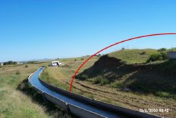
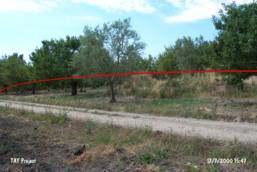
Kopruhisar (mound): c. 5,000 years old. During the sixties half of its deposit has been removed to be used as filler material to construct a haphazard dike on the banks of the routinely overflowing stream nearby. The southern and eastern sectors of the mound are completely cultivated. A field track cuts through the northern slope. |
 |
Kumocagi/Avariz (mound): c. 7,000 years old Chalcolithic Age mound. The entire deposit has vanished due to a deep and large sand quarry. |
 |
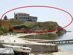
Kumbet Kocabahce (bath, mound): c. 5,000 years old. This settlement lies in the cultivated fields and orchards where a small antique city was established. Ruins associated with a bath are found on top of the higher ground which probably represents an Early Bronze Age mound. Stones from the antique ruins are used as building material for the border walls of the orchards. A large, deep pit dug by treasure seekers lies next to just such a wall. |
 |
Ucpinar (mound): c. 9,000 years old. To the east of the mound runs the main highway. The mound has been invaded by modern buildings from the west and northeast. A hospital and a parking lot will be constructed directly atop the mound. The surface has already been leveled. |
 |
Selimpasa Hoyugu (mound): c. 5,000 years old Early Bronze Age (EBA) settlement. Although it is one of the largest and most important mounds in Marmara Region, no precaution is taken against the threat of destruction. The entire surface is cultivated and a wall built right on top of the mound serves as the border between plots of land. The whole mound is surrounded closely by modern buildings. |
 |
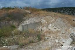
Tilkiburnu (mound): c. 7,000 years old. 25% of the mound soil is completely removed. A road runs through the mound cutting it in half. There is also a military bunker built right on top. |
 |
Toptepe (mound): c. 7,000 years old. Mound? Not quite! The discotheque of "Kaptan 2 Vacation Complex" instead... |
 |
Yarimburgaz Magarasi (cave): This c. 400,000 years old site manifesting the oldest traces of human settlements in Turkey to date. Treasure hunters have dug large sections of the floor and the walls of this cave by power tools. Buildings of the nearby town of Altınşehir have invaded the rocky ridges of the cave. The cave was once used as a movie set for a commercial movie production. Currently there is no evidence of protection or preservation as if worse is yet to come. |
 |
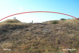
Yilanlık Mevkii (mound): c. 9,000 years old. A country road and an irrigation channel running alongside it cut its skirts. Archaeological artifacts are observed in the soil piled in the channel. The site has suffered massive destruction due to agricultural and settlement activities, mostly visible on the northeastern sector. The whole vicinity is leveled for cultivation and irrigation. Power poles are erected directly over the mound. |
 |
Yugucek-Iznik (mound): This c. 9,000 years old mound, originally measuring three meters high, is reduced down to only one meter. Apple orchards and six abandoned construction sites on the top, and ever increasing finished buildings on the eastern slopes complete the scenery... |
 |
Zincirlikuyu (mound): c. 5,000 years old EBA settlement. One of the largest mounds with its top razed and its soil removed from some sectors. Severe damage is observed due to irrigation activities throughout. A cement wall runs to the north and a gravel road cuts through the west. The western sector has the look of a garbage dump with mounds of gravel left over from the road construction, broken glass bottles and the like. It is ironic that this severely destroyed mound is actually an officially certified "primary archaeological site". |
|
|
|
 Tanindi, O. - M. Özbasaran et al., 2001, Archaeological Destruction in Turkey 2000 – Marmara and Aegean Regions, TAY Project - Scientific Reports Series 1/Eng, ISBN 975-6637-01-3, Istanbul. Tanindi, O. - M. Özbasaran et al., 2001, Archaeological Destruction in Turkey 2000 – Marmara and Aegean Regions, TAY Project - Scientific Reports Series 1/Eng, ISBN 975-6637-01-3, Istanbul.
|
 .. .. |
TAY Project . Kuruçesme Cad. 67/B
34345 Kurucesme Istanbul Turkey
Tel: +90 (212) 265 7858 - Fax: +90 (212) 287 1298
e.mail: info@tayproject.org |
| Copyright©1998 TAY Project |
|
|