


 |
|
 |
Expedition Data:
Duration of expedition: 88 days (April-September 2008)
Road traveled: 16804 km (10442 miles)
Provinces surveyed: Balikesir, Bilecik, Bursa, Çanakkale, Edirne, Istanbul, Kirklareli, Kocaeli, Sakarya, Tekirdag, Yalova.
Recorded visual data: 16.126 shots of digital photograph (36.6 Gb), 165 Gb of video
Archaeological Data:
Archaeological periods surveyed: Byzantine.
Number of target buildings: 466
Distribution of sub-periods over target buildings: 123 Early, 104 Middle, 38 Late, 12 Early+Middle, 1 Early+Late, 15 Middle+Late, 9 Early+Middle+Late, 164 Unknown
Distribution of building types over target buildings: 105 Church, 96 Fortification, 96 Cistern/Holy Spring, 33 Burial Building, 28 Monastery, 21 Water Channel/Aqueduct/Towel, 15 Palace, 14 Square/Monument/Hippodrome, 5 Cave, 5 Bath, 5 Baptistery, 5 Bridge, 33 Unknown, 6 Other.
Number of buildings not visited: 30 (Sites in military zones; completely demolished sites; sites presented just by name in publications)
Number of buildings not documented: 44 (Sites with scarce description of location; sites utterly destructed by agriculture or by contemporary settlements)
Number of documented buildings: 427
Destruction Data:
Number of documented buildings subject to destruction: 377
Distribution of types of destruction over documented buildings*: 228 Contemporary settlements, 142 Highways, roads, bridges etc., 135 Natural causes, 80 Subsequent occupation, 76 Illicit digging, 20 Agriculture, 3 Mines/Quarries, 11 Other.
(Numbers mentioned above include more than one destruction type on a single building)
Types and description of destruction by district:
Housing resulting from unplanned urbanization account for majority of the destruction on the Byzantine buildings in the Marmara Region. It has been observed that impact of unplanned and unguided urbanization on the Byzantine sites in Kocaeli, Bursa, and mainly in Istanbul has already reached to an irreversible extent of damage. Also, destruction by organizations such as municipalities of Kocaeli, Istanbul, Bursa and Adapazari, Ministry of Agriculture and Rural Areas, State Hydraulic Works and Highway Commission are noteworthy in the Marmara Region, which has an intense transportation network. In addition to this type of destruction encountered in metropolitan districts and dense residential areas, new road constructions and enlargement activities have considerable impact, which can be clearly observed in cities with rapidly increasing populations such as Iznik, Silivri, Çatalca, Vize and Hereke.
Along with these factors, selection of localizations for motorways, water tanks, high-voltage transmission lines, wind turbines, plants and dams within the scope of social requirements and developing technologies near cultural assets and their vicinity increases intensity of irreversible damages exposed on these assets. Destruction by unplanned housing and new areas to be developed based on rent-seeking in cities like Istanbul, Bursa and Kocaeli and their vicinities is the most important factor to deal with in this region.
Destruction by illicit diggings observed in the areas other than city centers and in almost any of the architectural remains in the Marmara Region results in extinction of stratifications and elements characterizing these stratifications such as walls, decorations and finds in such an extent that they can not be systematically examined anymore. Illicit diggings are more common in Kirklareli, Iznik and Bursa.
The destruction type so-called subsequent occupation, which is frequent particularly in the Byzantine buildings, is another type observed in the region. This type of destruction can be analyzed in several groups including cities, villages and unpopulated places. In cities, destruction is mostly reflected by architectural modifications in churches, which had been converted into mosques. Removal of figurative Byzantine paintings, and religious motifs such as crosses by various methods for religious purposes represents the most significant type of destruction. Prominent methods include painting of marble architectural elements, destroying pavements, installation of modern door and window systems onto openings. In villages, it is common that Byzantine remains are mainly occupied as warehouse, barn and sheepfold. It was observed that the interior of Byzantine remains in unpopulated areas, mainly of fortresses, are intensely used as sheepfolds while their surrounding areas are cultivated as fields.
One of the most interesting results is that destruction type so-called natural destruction accounts for major part of the destruction among all others. In case of Byzantine remains, weeds play a significant role in the destruction of remains. It is very common to observe tree roots damaging foundations of buildings, tree branches leading to collapse of walls or deformation of walls by roots developing inside the walls, particularly in the northern wooded sections of the Marmara Region.
The major destruction exposed by a single factor, at least as much as housing, is caused by establishments such as mines and quarries. Damages by such establishments, operating without evaluation of regional historic background, are every common in the provinces of Balikesir and Bursa.
*Clarification of primary causes of destruction:
Contemporary settlements: Houses, hotels, recreational areas and holiday complexes, petrol stations, factories, dams, power lines, pipelines, cemeteries, etc.
Agriculture: All kinds of agricultural activity on and around the sites / buildings (afforestrations, cultivation, terracing, levelling, soil removal, irrigation channels, etc.).
Subsequent occupation: Architectural modifications and alterations made for subsequent usage of the building (church used as a mosque, cistern used as a restaurant, castle used as a barn, etc.)
Illicit digging/treasure hunting: By locals and smugglers.
Mines/quarries: Stone, sand and lime mining.
Highways/roads: Highways, country roads and railways passing over or through archaeological sites / buildings, bridges built upon historical structures.
Natural causes: Earthquakes, fires, soil erosion, riverbed reformations, floods, etc.
Other: Unappropriate intervention / restoration, etc.
|
|
|
Samples from Visual Documentation of Destruction
|
|
|
 |
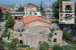
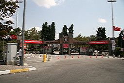
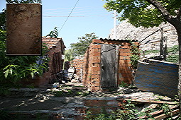
Northern Necropolis of Izmit: The building complex at the Orhan Quarter to the north of Izmit is one of the most important ancient cemeteries in the region with public type of graves from the Late Roman and Early Byzantine Periods. Dated to the 4th century, they are now under the threat of a ring road linking to the Istanbul-Ankara highway, and of one of the most rapidly developing quarters of Izmit known as Turgut Mahallesi. |
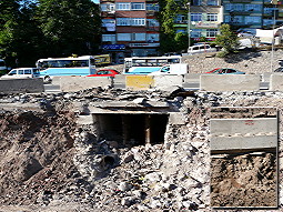 |
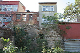
City Walls of Izmit: First erected by Nicomedes I (278-250 BC), founder of Iznik (Nicomedia), the extant sections of the walls bear traces of four main periods from the 4th century till the 15th century. The sea walls were destructed and demolished during the construction of the D-100 motorway in 1995. Recently, the construction of an underpass at the SSK Junction revealed that re-exposed walls extend for approximately 2 km. At present these fortifications, older than 2000 years, still traceable at some sections, will be demolished during these road construction activities, and the distance between Istanbul and Ankara will be shortened for 2 minutes more by the highway. |
 |
Church Ruins 2 at Iznik: Unfortunately the destiny of Iznik Church 2, dated to the 11th century is not any different than the other churches in Iznik. The southern section has been obscured by the parking lot, the northern section by the road, and the eastern section by the shops. On top of it, trees planted by local authorities as if they are implying that “we destroyed all, but at least it looks nice”... What remains from the church is only a wall of one or two rows, and a stone of one or two pieces... which also will be lying under the parking lot very soon. |
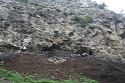 |
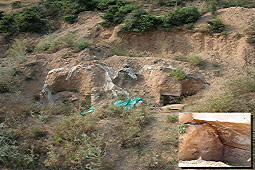
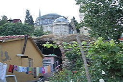
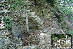
Direkli Cave Monastery: This cave monastery situated near Vize is a complex entirely carved into the rocks. It consists of many rooms, and a large church, but now it shelters stray dogs and goats. It is almost impossible to access the monastery due to inhospitable dogs and owners of the shelter, which is full of goats anyway. |
 |
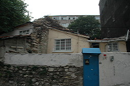
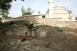
Ayasofya Church of Iznik: Ayasofya, which is situated at the district center of Iznik, has been completely modified due to recent interventions by unexperienced, ignorant and unconscious authorities and contractors in such a way that almost nothing has been left from its original identity and historical value. With its collapsed walls, high tile hipped roof, flaked off domes, openings closed by glass, minaret built with concrete, electrical wirings and water pipes... |
 |
Church Ruins 1 at Iznik: Situated near the Istanbul Gate at Iznik, only the southern section of this 11th century church is still extant. Part of the church had been demolished during the construction of the Kumbasi Street while the remaining parts were destroyed during the enlargement activities of the same street in 2006. The environs of the church have been converted into a public park, with trees planted and benches installed. The architectural elements of the building were used for the park benches. The only thing that is done in the name of preservation of cultural assets nowadays is that: the church is being washed every day! |
 |
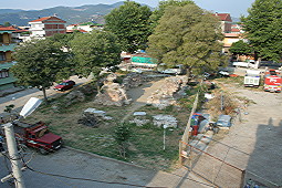
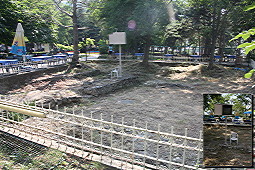
Building Remains at Iznik: These remains in the Mustafa Kemal Pasa quarter were excavated between 1988 and 1994. The building complex with a large church was presumably part of the Iznik Palace during the Byzantine period. However, many new buildings, including the Bagkur Houses, have been, and are still being, constructed over the remains. Walls to the right and left, scattered fragments of ceramics on the ground, surrounding architectural elements here and there... Apparently the contractor convinced the Preservation Board that the area is free of any artifacts so that they laid the foundations of his modern building right on top of the Byzantine structure. |
 |
Church Near Iznik Theater: Nobody recalls this church, lying to the immediate east of the Iznik Theater, as a church anymore. As locals refer to it, it is now “a warehouse, not a church!”. Why? Because until recently it had been used as a warehouse and a barn. On top of it, this building currently filled with garbage up to the roofing, and partly obscured by the newly built roads, is a registered site which had been excavated within the scope of excavations initiated at the Iznik theater. |
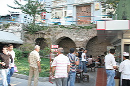 |
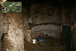
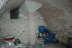
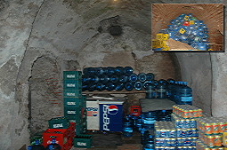
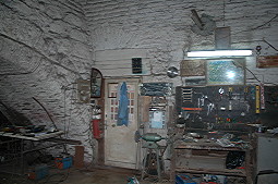
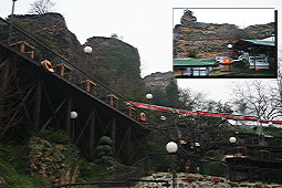
Beyazit Cistern 1: Two of the three cisterns located in Beyazit were demolished during the construction of subterranean passage at Vezneciler. One of these can still be seen right below the precinct and electric company at the beginning of the tunnel. The refreshment booth, adjacent to the two extant colonnades of the cistern in east-west direction arranged a seating area inside the cistern for their clients. The roof and the decorated capitals of the cistern that extend under the buildings at upper level, so to speak, invites (!) us to have “döner kebab under cistern”. |
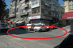 |
Atpazari Cistern: This is the intersection of the Mihçilar Avenue and the Keserciler Street in the Kirmasti Quarter of Fatih District. Here, there is a large cistern, which was unearthed during the installation of telecommunication lines by PTT in 1978. The survey conducted during that period revealed that the cistern measures 35x18 m in dimensions. At present, it has been obscured by many blocks of flats and two avenues. |
 |
Cistern at Esrefzade Quarter of Iznik: The cistern is situated on the Esref Eroglu Street of the Esrefzade Quarter. Only a few ruins are available, hardly noticeable among high grass. The process of destruction was initiated in 1972 when the landowner demolished the cistern by bulldozers to construct a road and a building. The cistern doesn’t exist anymore. Ironically both the cistern and the quarter were named after the demolisher: Esrefzade Quarter - Esrefzede Cistern. |
 |
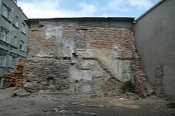
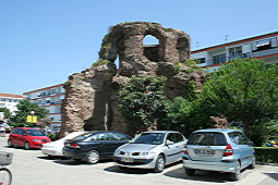
Balaban Aga Masjid: The excavation of the Balaban Aga Masjid by Arif Mufid Mansel in 1930 is the first excavation conducted in the Istanbul Citadel by the Turkish scientists. Mansel published his excavation results within the same year. Actually a 5th century Byzantine burial structure, it was converted into a mosque during the 15th century right after the Sultan Mehmed II period. The building suffered grave damage from a fire in 1911, and it was completely demolished during road enlargement works in 1930. This picture shows current view of the place where the small mosque used to be located at, in the Balabanaga Quarter of Fatih District. |
 |
Abdülvahap Burial Chamber: You may look at this picture and think “See, these Byzantines had even plastic graves”, but this not the case here. It is actually our artistic production... three burial chambers under plastic covers and a pile of soil – all decorated with paintings, dating back to almost 1700 years ago. Following the salvage excavations by the museum in 2006, the burial chambers were packed in plastics and covered with a heap of earth. And, then in 2008 State Hydraulic Works threw opened the chambers while trying to open channels! And, later on, thanks to those people highly interested in history (!) the burial chambers dating to the Byzantine Period became like this. |
 |
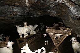
Balkaya Church 1: There are 3 cavern churches in the Kiyiköy District of Kirklareli, which are very close to each other. All three churches are currently used as goat shelters. As seen in this shot, many decorations including the cross figures are destroyed to make sure that the goats are not disturbed in any way! But more harm was given to these churches by robbers than these “ignorant” goats. The small picture shows one of the illumination gadgets used by these treasure hunters. |
 |
Evrenli Cave: Since it is a very common practice in Thrace, we see that this cave is also used as an animal shelter. With clear traces from the Byzantine Period, it is under the threat of constant destruction, apparently due to lack of another spot in the region to shelter the goats and for the sake of their owner. |
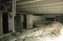 |
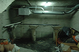
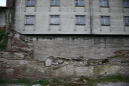
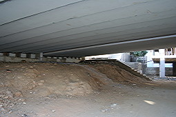
Beyazit Church D: There are late 11th century church remains on the basement of the Faculty of Sciences of the Istanbul University at Laleli in the section where there are lecture halls and the boiler room. The boiler that is used to heat the faculty building is right at the center of the church. Next to this building, subway construction works continue on the Resit Pasa Avenue. |
 |
Remains Underneath the Hotel Grand Savur: A large section of the remains unearthed during the construction of the Hotel Grand Savur in the Sehzadebasi Quarter of Eminönü District in Istanbul in 1990 is currently being used as boiler room of the hotel. The remains, actually extending under the hotel across named the History Hotel, have been already under protection! As seen here, even fake columns were erected at the center to support the building, and the walls were strengthened with concrete. Now the clients of the hotel can sleep in peace in their rooms! |
 |
Remains at Acimusluk Street: This magnificent building at the intersection of the Cagaloglu Ramp and the Cemal Nadir Street in the Hobyar Quarter of Istanbul, is probably part of one of the few extant Byzantine palaces in Istanbul. This enduring structure, of which another section was partially exposed during the construction of an inn nearby, and then immediately demolished in 1965, still supports a huge “inn” even today. It has been currently used for storing soft drink crates. So, if you’d like to have some refreshments from the cellar of the Botaniates’ palace ... |
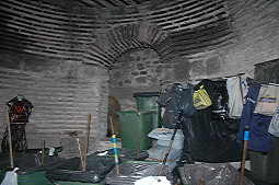 |
Kalenderhane Mosque: Interior of the chapel dating to the 12th century, lying to the northeast of the Kalenderhane Mosque, one of the most important Byzantine artifacts in Istanbul. This section, which was allocated to a cleaning contractor by the municipality, is no longer a church or a religious building, but a storage facility. Furthermore, a huge iron door was installed at the entrance to keep their invaluable garbage carts and brooms from being stolen. |
 |
Remains Underneath the Adem Trade Center: These remains can only be accessed through a fabrics shop at the bottom floor of the Adem Trade Center on the Ali Suaip Street at No. 25 in the Balaban Aga Quarter of Eminönü District. It is used as warehouse of a trade center which was constructed upon permission immediately after the salvage excavations performed by the Archaeological Museums of Istanbul between 1990-91. The Byzantine architectural elements have been superimposed for decorative purposes to have a “nice” ambience. |
 |
Karpos - Papylos / Menas Church: The church which was dated to the 5th century is situated on the Nafiz Gürman Avenue in the Samatya Neighbourhood of Istanbul. The building was used as a nunnery between the 10th and 12th centuries, and now it houses two shops, an iron workshop and a car wash shop. Believe it or not! |
 |
Konstantinos Lips Church / Fenari Isa Mosque: Founded by a Byzantine admiral in 907, it was converted into a masjid in 1496, and then into a mosque in 1636. It is located in the Hasan Halife Quarter of Fatih District in Istanbul, and it currently serves as a mosque. It represents example of the most effective destruction by subsequent occupation in Istanbul documented with its PVC coverings, interior full of carpets, extent of destruction caused by electrical and water pipes. |
 |
Soganaga Trade Center: This building underlying the Star Trade Center at Laleli, a neighbourhood which witnessed one of the greatest destructions on the Historic Peninsula, probably dates to the early Byzantine Period. No systematic investigation was carried out on the remains, which were exposed during the construction of the center in 1996-97. Suffering under steel pillars erected to support approximately 50 shops inside the trade center, this Byzantine structure extends under the adjacent trade centers and shops. And if this is not the perfect example of a terrible destruction, then, what is it? |
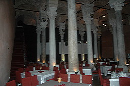 |
Cistern at Sivasi Tekke Masjid: There is a huge 5th century cistern under the Sivasi Tekke Masjid which did not survive to the present day at the intersection of the Yavuz Selim Avenue and the Ali Naki Street in the Fatih District of Istanbul. Currently known as Sultan’s cistern, it is being used as a restaurant, it is nowhere near a cistern anymore, no matter whereever you look at it from... |
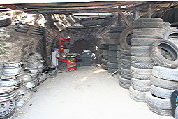 |
Bogdan Palace: What you see here is part of a 13th century Byzantine church. Located on the Draman Avenue in the Fatih District, the remains are being used as a tyre repair shop at present! See what became of cultural assets. That must be the real essence of preservation! If these remains, which are almost to be completely vanished, are not urgently taken under protection, a little while later another photograph will display nothing else, but the “emperor’s car wheels”... |
 |
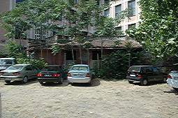
Bonos Palace: The remains near the Islamic-Ottoman Social Complex of Sultan Yavuz Selim in the Muftu Ali Quarter of Fatih District in Istanbul, belong to a Byzantine palace. The houses inside the palace and the dense urbanization in the environs will pretty soon destroy all traces of the palace. |
 |
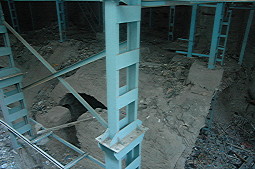
Antiochos Palace and Euphemia Church: Several salvage excavations were conducted in this important building situated at Sultanahmet as a 5th century palace and church between 1952 and 1964 before construction of the modern courthouse of Istanbul. A large section of the remains were destroyed as a result of this construction. Wall painting consisting of 14 scenes depicting the biography and the tortures experienced by Saint Euphemia from the 13th century lie to the west of the neglected remains that are situated in the parking lot of the courthouse. These frescoes will also disappear soon if not protected just like others which were on other sections of the remains known to be existing until very recently. |
 |
Rhegion Palace: The Rhegion Palace dating to the 5th century was a building complex that consisted of many structures. An important part of this complex was situated in the Cennet Quarter of Küçükçekmece in Istanbul. We use past tense because there are no traces of the palace at present except for four columns. The enormous land on the “Antika Avenue” where the palace was once located, clearly shows how the cultural assets get destroyed and lost from the records of history. |
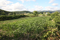 |
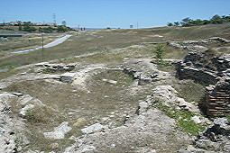
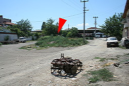
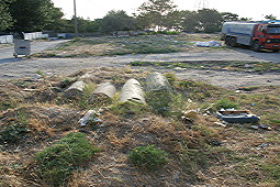
Cave Fortress: There is no fortress in this shot, you can only trace only a few irrigation canals here and there, new plantation areas, and some collapsed walls. From the Cave Fortress lying to the south of the Magara Village in the Sögütlü District of Sakarya, nothing but only some building stones remained under the roads running over its four walls at present. This is an example of how destruction by agriculture destroyed a Byzantine fortress. |
 |
Çatalca Fortress: The fortress resting in the Kaleiçi Quarter of Çatalca has been under the threat of intense destruction resulting from urbanization and new road constructions. Who bothers for a new foundation while there are Byzantine walls all ready. Some leveling on top of these fortifications, and adding the fallen stones into the foundation; here we go, we have our house ready! Who cares about preservation anyway! In case of any hostile attack, we pull them back... |
 |
Edirne Walls: The walls which protected Edirne for approximately 1000 years from the 2nd century to the 12th century are in urgent need of protection. In fact, nothing has been left to protect. This shot portrays the modern buildings rising above the chapel dating to the 10th century, situated to the immediate southeast of the Macedonian tower, which is the only remaining structure from the Edirne walls. The chapel itself had been almost completely destroyed 25 years ago with a building constructed over it. |
 |
Ahmetli Fortress: The building stones of the fortress situated at Gölboyu Mevkii of the Ahmetli Village in Çatalca were used in the construction of the road. Some foundations were demolished during the construction of canals in the region. Parts of the walls can be traced inside the lake, while the bastions on the land are used as fishermen’s shelter. Plenty of sherds and building elements has been scattered around. |
 |
Yoros Fortress: The only extant Byzantine fortress in Istanbul dating to the 13th century is situated at Anadolu Kavagi. Therefore, it is increasingly under the threat of heavy destruction due to rent seeking opportunities in this region. Particularly the southern walls were destructed in 2005 to be used as a tea garden and restaurant. |
 |
Kerpe Fortress: It rests on a rocky area overlooking the sea to the north of Kerpe in the Kandira District of Kocaeli. Nothing was left from the fortress, in which the ancient harbor of Kerpe is also situated, except a few meters long wall and a few vacationers who go swimming from the rocks! |
 |
Aya Sotiri Church: Nothing remained from the Byzantine church, which was located at Kumi Mevkii of the Zeytinbagi Town in Mudanya. The church collapsed completely, and a concrete flimsy house was built upon it. The people who constructed the building were also involved in a number of illicit diggings around and inside the church. Now, deep pits dug by treasure hunters are observed inside the building, which has been already abandoned. |
 |
Ayakapi Chapel: A building and a log storage were built above what was left from the Ayakapi Chapel, which was dated to the 11th and 12th centuries (situated in the Ayakapi Street of the Abdi Subasi Quarter in Fatih District). The apse of this small church, where the priests offered their services, now can be seen through the piles of logs inside the store. We have seen churches converted into mosques, but this is the first example of a church converted into a timber shop... |
 |
Veliefendi Hippodrome or Campus Tribunalis: Campus Tribunalis was a famous Byzantine structure complex, famous with its swimming pools and baths lying on a very large piece of land. This area which was built by Emperor Valentinian I in the 4th century had stepped seatings called tribunal. This unfortunate area was also a camping site for the Byzantine army before and after a campaign. It is currently being used as Veliefendi Hipodromu. That means, where Valentinian I saluted his armies in the 4th century, now the bets are on horses... |
 |
Ayasofya of Edirne: Courtyard of the old warehouses of the State Monopoly, now the Murat I High School in the Kaleiçi Quarter of Edirne. It is known that once the church of Ayasofya was rising in that courtyard. And now it is completely “gone with the wind”... |
 |
Kara Kilise: It represents a very important example of the Byzantine architecture with its masonry consisting of solely bricks, from the Early Byzantian Period. It is situated at the Baskent Summer Resorts 1 in the Sahil Quarter of Çiftlikköy in Yalova. Lying in the middle of the recreation center which is in the service of inhabitants and vacationers, it survived many destructive earthquakes, but looks helpless against the harm human beings can give. |
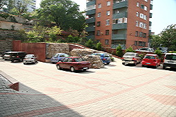 |
Building at Merdivenköy: The monastery remains at Merdivenköy in the Kadiköy District of Istanbul are currently being used as parking lot of an apartment complex built in 2005. Forget its authentic identity, it is now nothing, but an element of landscaping. The major part of the structure was destroyed during the construction of this building. |
 |
Odalar Mosque: Almost no remains are available from the building situated at the Karagümrük Neighbourhood of Fatih District. Being used until a fire in 1919 with many modifications, it was considered as an important artifact representing the Byzantine architecture as well as wooden architecture of the 19th century. As of today, only some walls can be seen among the houses on the Kasim Odalar Street. |
 |
Osmangazi Building Complex: These building remains which were unearthed during a campaign by the Bursa Museum in 2000, are situated inside a public park at Hisar in the Osmangazi District of Bursa. It seems that the nice Bursa view from the park was not enough, so the business owners decided to place a TV set inside the tea garden, which was installed by hammering a steel support inside the 1000 years old walls... |
 |
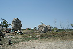
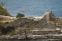
Pylaea Fortress: Based on the resources, the Pylaea fortress was built by Emperor Manuel Comnenus in 1145. What remained of the fortress’ harbor at the Huzur summer resorts in the Çiftlikköy District of Yalova can be seen in this picture. The enclosing walls of the summer resorts were seated onto the fortress walls. It is known that the fortifications were destroyed during the construction of the resorts. Usually preferred by vacationers looking for peace in summer, these resorts gave no rest to the 900 years old Pylaea fortress. |
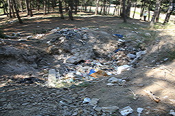 |
Theodoros / Tahtali Church: What survived from the church situated just out of the Tahtali Village to the west of Bursa is a large pit, full of garbage. Many building elements are scattered around the church, situated in the middle of the wood, and many pits are observed in the vicinity due to illicit diggings. |
 |
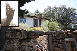
Triada Chapel: This cave which had been inhabited since the Hellenistic Period was also used as a subterranean church during the Byzantine period in the 14th century with its own cemetery. This impressive chapel, with plenty of frescoes on its walls, is accessible through a flimsy cottage in the garden of a house at the Gazi Ömer Quarter of Enez District in Edirne. The description of St. Mary carved onto the rock witnessed numerous illicit diggings, waiting for a hand to reach her along with the skeletons exposed during these illicit diggings. |
 |
Tetraconchos of Vize: It is believed that the tetraconchos, i.e. four bays in semi-circular plan covered by a half-dome and added symetrically onto a central bay, was used as a baptistry or martyrion monumental building above the graves of religious martyres). This tiny structure is situated next to the Sarapdar Hasan Bey Camii in the district of Vize at Kirklareli, and a major part of it has been destroyed, some parts extending under courtyard wall of the mosque, and the remaining parts used as chicken coop. |
 |
Yurtyeri Monastery: The remains situated at Cumali Kizik on the skirts of the Uludag mountain in the Yildirim Quarter of Bursa probably belong to one of the many monasteries well-known in the region. No systematic survey has been conducted at the site yet. The structure and its building elements had been completely shattered by the thieves, and the eastern section disappears gradually towards the Balıklı stream due to landslide. |
 |
Pendik Monastery: A very important Byzantine structure excavated by the Istanbul Museums of Archaeology between 1973 and 1975: Pendik Monastery. Even registered! The monastery which is situated at the intersection of the Visne Street and the Cinardere Viaduct while driving from Pendik to Kurtköy, almost disappeared under the apartment blocks which are still under construction and the viaduct which was finished between 1995-96. Here is the Pendik Monastery! |
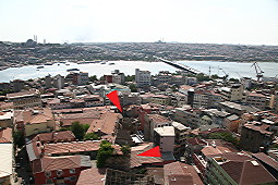 |
Galata Walls: This shot beautifully displays how the Galata walls disappear under such an urbanization process. The two large bastions, -as shown with arrows - are situated to the southwest of the Galata tower. These bastions from the Galata walls which were systematically destroyed from 1864-65 till now survived to the present day along with the Galata tower, and limited number of wall remains near the tower, walls at Azapkapi and Yanik Gate. |
 |
Istanbul Walls: All destruction types are visible on the Istanbul walls: Since some sections just “took off and flew away” during the construction of the main roads near Edirnekapi and Topkapi, and some other parts on the seaside “were taken away” during the construction of railways, nothing can be done anymore to save these. And we are all familiar with the unskillful fictitious restoration implementations. Housing seen almost everywhere now became an ordinary part of the walls. The trees that grew on the walls and the plantation fields around add to the momentum of the destruction process. The attack against historic assets is being poorly hidden by a humongous performing arts’ scene veiling the Yedikule walls, however it is far from concealing the horrible destruction on the 21 km long walls... |
|
|
|
 Tanindi, O. - Ö. Kurt et al., 2009, Archaeological Destruction in Turkey, Year 2008 Preliminary Report – Marmara Region Byzantine Period, TAY Project - Scientific Reports Series 16/Eng, ISBN 978-975-807-230-9, Istanbul. Tanindi, O. - Ö. Kurt et al., 2009, Archaeological Destruction in Turkey, Year 2008 Preliminary Report – Marmara Region Byzantine Period, TAY Project - Scientific Reports Series 16/Eng, ISBN 978-975-807-230-9, Istanbul.
|
 .. .. |
TAY Project . Kuruçesme Cad. 67/B
34345 Kurucesme Istanbul Turkey
Tel: +90 (212) 265 7858 - Fax: +90 (212) 287 1298
e.mail: info@tayproject.org |
| Copyright©1998 TAY Project |
|
|