Expedition data:
Duration of expedition: 43 days (September - October 2000)
Road traveled: 7064 km (4,388 miles)
Surveyed provinces: Adiyaman, Batman, Diyarbakir, Gaziantep, Kilis, Mardin, Siirt, Sanliurfa, Sirnak.
Recorded visual data: 1094 shots of analog photograph, 1867 shots of digital photograph (1000 Mb), 15 hours of video
Archaeological Data:
Archaeological periods surveyed: Palaeolithic/Epipalaeolithic, Neolithic, Chalcolithic and EBA
Number of target settlements: 338
Distribution of archaeological periods over target settlements: Palaeolithic/Epipalaeolithic: 66, Neolithic: 27, Chalcolithic: 133, EBA: 45, Chalcolithic + EBA: 25, Neolithic + Chalcolithic + EBA: 4, Neolithic + EBA: 6, Other: 32
Distribution of settlement types over target sites: Mounds: 218, Single find-spots: 31, Flat settlements: 25, Habitation sites/Ateliers: 23, Caves: 12, Artifact scatters: 5, Rock-schelter:3, Cemeteries: 1, Other: 20
Number of sites not visited: 128 (Sites in military zones; completely demolished sites; sites presented just by name in publications; under the dam)
Number of non-documented sites: 16 (Sites with scarce description of location; sites utterly destructed by agriculture or by modern settling)
Number of documented sites: 194
Destruction Data:
Number of documented sites subject to destruction: 174 (Apart from this destroyed sites, 64 settlements have been destroyed by the dams)
Distribution of types of destruction over documented sites: Dam: 64, Contemporary settlements: 53, Agriculture: 46, Agricalture + Cont. settlements: 28, Natural Causes + Cont. settlements: 15, Illicit digging/treasure hunting + Agriculture: 13, Illicit digging/treasure hunting: 9, Natural Causes: 5, Mines/Quarries: 5
Types and description of destruction:
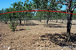
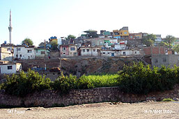
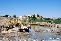
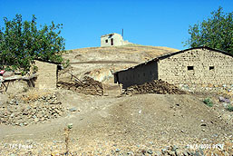
Throughout this region, contemporary settlement constructions comprise the highest rate of destruction, followed by agricultural activities. To date, known 64 archaeological sites are flooded and completely destroyed because of the construction of dams on the two most important rivers of Asia-minor and the Middle East. In addition, almost 30 additional sites are about to be flooded. Contemporary settlements (building constructions on mounds, roads, infrastructure etc.) have wiped out 22% of the archeological remains while cultivation accounts for 19% of the destruction. This type of destruction was observed at 174 of the 194 sites covered by TAYEx field team. The cumulative destruction rate reaches to 72% with erosion, natural causes and treasure hunting. On the other hand the destruction rate caused by the infamous dams is 28%. Many other factors, (e.g. leveling of the mounds due to agricultural activities) seem to be as destructive as the dams, hydroelectric power plants, and irrigation systems. |
|
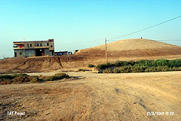
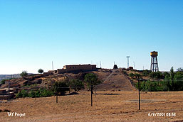
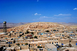
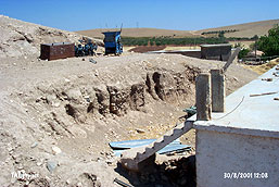
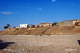
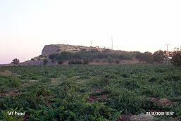
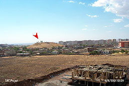
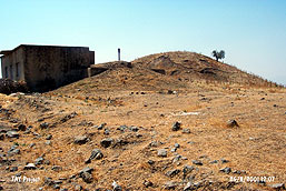
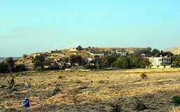
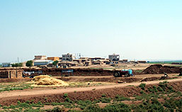
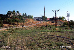
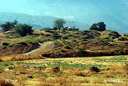
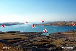
Samples from Visual Documentation of Destruction
|
|
|
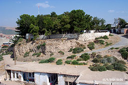 |
Adiyaman Hoyuk (mound) (Adiyaman/Merkez): The slopes of the Chalcolithic and Early Bronze Age mound is occupied by the houses of old Adiyaman. A pine grove lies on the site. Soil was removed from the slopes, and cobblestone roads, and concrete stairs were built. There are paved roads between the houses. Although it is known as "the castle", there are no remains of a castle except a café named Kale. |
 |
Arikok Hoyuk (mound) (Sanliurfa/Bozova): The mound is about to be destroyed due to contemporary settlements on the slopes. There are treasure pits on the southern corner. |
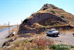 |
Ariski Tepe (mound) (Batman/Merkez): c. 7000 years old. The eastern part of the mound is completely razed off by a highway. Soil was removed from the northeastern corner to build a parking lot where a transformer and a high voltage line are situated. Many treasure pits are visible, especially the one on the northeastern corner is quite large. The restaurants on the side of the road are built on the skirts of the mound. A secondary road cuts through the skirts. |
 |
Asagikeferzo (mound) (Batman/Merkez): Numerous mud-brick houses and buildings of cement-blocks lie on the Chalcolithic Age mound. Remains of a church are visible on top. |
 |
Duran (Çerme) (mound) (Sanliurfa/Harran): Northern corner was leveled and completely destroyed. Two-story high concrete building was constructed. |
 |
Embil Koy (mound) (Diyarbakir/Dicle): There is a water reservoir on the west, a garden and a road close by on the northwestern corner. A well was dug on the northern slopes, and soil was removed field expansions. The site is about to be completely wiped out due to contemporary settlement. |
 |
Girharrin (mound) (Mardin/Merkez): Massive amounts of soil was removed from all the slopes of the Early Bronze Age mound. Modern houses lie on the skirts. It is about to be destroyed due to contemporary settlement. |
 |
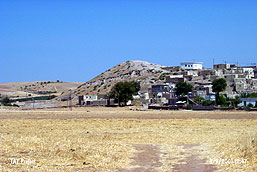
Gok Tepe (mound) (Sanliurfa/Siverek): 7000 years old. Intensive destruction due to contemporary settlements around the site is observed. Traces of soil removal for building construction is clearly visible. There are illicit digger pits on top of the mound. |
 |
Haci Mehmet Hoyuk (mound) (Gaziantep/Nizip): The Chalcolithic Age mound was completely leveled for cultivation. 20-30 years old peanut trees lie on the site. Scattered artifacts are visible. |
 |
Iluh (mound) (Batman/Merkez): There is a planned, modern settlement on top of the mound. It is leveled in layers. Layer by layer leveling that took place progressively is clearly visible. |
 |
Kefri (mound) (Gaziantep/Nizip): The mound is underneath the village of Kefre in the present. The eastern corner seems like a 10 m high cliff cut off by the Euphrates. |
 |
Kiriskal (mound) (Gaziantep/Islahiye): The skirts of the Early Bronze Age mound was terraced, and houses were built. There is a water reservoir on top of it. The village has moved towards the mound. Soil was removed from the skirts, revealing the bedrock in some places. |
 |
Kolebaht (mound) (Diyarbakir/Ergani): Intensive contemporary settlement is recorded on the Early Bronze Age mound. The western corner is cut off by a creek. |
 |
Leylit (Sahinonu) (mound) (Kilis/Merkez): Almost half of the mound is destroyed for cultivation. A 30 m high section is visible. A police station is located on top of the mound. |
 |
Payazkoy (mound) (Diyarbakir/Merkez): It is surrounded by modern buildings. It is underneath the graveyard of Payaz Village. The northern skirt is terraced. |
 |
Sak 27/Çakmak Hoyuk (mound) (Gaziantep/Islahiye): The mound leans against a natural elevation. There are illicit digger pits on top, and a water reservoir on the skirts. |
 |
Satir Hoyuk (mound) (Gaziantep/Sakçagozu): Intensive destruction due to soil removal and contemporary settlement on this site is observed. |
 |
Seferkoy (mound) (Sanliurfa/Harran): Intensive destruction due to foundation and infrastructure construction is observed on this Chalcolithic Age mound. |
 |
Surtepe (mound) (Sanliurfa/Birecik): The mound is buried beneath the houses of Surtepe Village. The eastern skirts are cut off by the Euphrates, while the western and northern skirts are razed off by a secondary road leading to the village. |
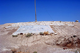 |
Tilmiz (mound) (Siirt/Merkez): A large area was used as a water reservoir on this mound, revealing a 2 m high section. Concrete is poured near the reservoir. The name of the village is inscribed on the mound using small stones. Soil was removed from the northern corner, and houses lie on the skirts. Intensive destruction due to cultivation is recorded. |
 |
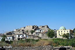
Zincirli (mound) (Gaziantep/Islahiye): The excavated mound is partly occupied by a modern settlement. The existence of a water reservoir, illicit digging, and soil removal are some of the causes of destruction. A part of the lower city rampart was revealed when soil was removed in 2000. |
 |
Almalik Tepe, Anep Sirti, Asagi Hamili Harabesi, Baskale, Bedri Ibo Tepe, Bendersovti Sirti, Biricik Hoyuk, Burhan Hoyuk, Çavi Tarlasi, Çekis Sirti, Gavurtepe, Gri Memo Mevkii, Gritille, Hasimerte Baglari, Hassek Hoyuk, Hayaz Hoyuk, Horum Hoyuk, Karadut Mevkii, Karmitlib Hoyuk, Kumartepe, Kurban Hoyuk, Kuçuktepe, Lidar, Meyan Hoyugu, Miroglu, Nevali Çori, Samsat, Suleymanbey Harabesi, Suruk Mevkii, Saskan Buyuktepe, Tille, Toprakkale, Yenikoy etc... |
|
|
|
 Tanindi, O. - S. Seba et al., 2002, Archaeological Destruction in Turkey, Year 2001 Preliminary Report – Meditarranean and Southeastern Anatolia Regions, TAY Project - Scientific Reports Series 8/Eng, ISBN 975-6637-07-2, İstanbul. Tanindi, O. - S. Seba et al., 2002, Archaeological Destruction in Turkey, Year 2001 Preliminary Report – Meditarranean and Southeastern Anatolia Regions, TAY Project - Scientific Reports Series 8/Eng, ISBN 975-6637-07-2, İstanbul.
|
|