


 |
|
 |
Expedition Data:
Duration of expedition: 63 days (June - August 2001)
Road traveled: 14282 km (8,874 miles)
Surveyed provinces: Adana, Antakya, Antalya, Burdur, Isparta, Içel, Kahramanmaras, Karaman, Konya, Mugla, Osmaniye.
Recorded visual data: 2150 shots of analog photograph, 3779 shots of digital photograph (2100 Mb), 35 hours of video
Archaeological Data:
Archaeological periods surveyed: Palaeolithic/Epipalaeolithic, Neolithic, Chalcolithic and Early Bronze Age.
Number of target settlements: 456
Distribution of archaeological periods over target settlements: Palaeolithic/Epipalaeolithic: 26, Neolithic: 27, Chalcolithic: 65, EBA: 175, Neolithic + Chalcolithic: 21, Chalcolithic + EBA: 53, Neolithic + Chalcolithic + EBA: 31, Neolithic + EBA: 13, Other: 45
Distribution of settlement types over target sites: Mounds: 358, Flat settlements: 27, Caves: 19, Slope settlements: 7, Rock-shelter: 7, Single find-spots: 5, Habitation sites/Ateliers: 3, Cemeteries: 2, Artifact scatters: 1, Other: 27
Number of sites not visited: 39 (Sites in military zones; completely demolished sites; sites presented just by name in publications)
Number of sites not documented: 23 (Sites with scarce description of location; sites utterly destructed by agriculture or by contemporary settlements)
Number of documented sites: 394
Destruction Data:
Number of documented sites subject to destruction: 341
Distribution of types of destruction over documented sites*: Agriculture: 168, Contemporary settlements: 64, Agriculture + Cont. settlements: 44, Illicit digging/treasure hunting + Agriculture: 28, Illicit digging/treasure hunting: 22, Highways, roads, bridges etc.: 5, Natural causes: 5, Mines/quarries: 2, Other: 3
Types and description of destruction by district:
Western Mediterranean: Agricultural activities are the most common causes of destruction in this district (which includes the area from Fethiye and the Lake District to Anamur). Small and medium mounds are leveled off for cultivation while larger mounds usually escape with only their tops cut off. In the plains of Tefenni and Elmali, parceling down the fields into smaller plots has played an important role for this type of destruction. Locals claim that, especially in the last twenty years, destruction caused by agricultural activities have increased, and in fact reached epidemic proportions. On the other hand, a different kind of destruction has taken place in Burdur and its provinces since the 1960s: Illicit digging. Illicit digging has become a ‘life style‘ in some cases. Destruction due to cultivation and illicit digging is also prominent in the interior parts of Antalya Province, while destruction by construction activities are observed mainly at the coastal areas.
Central Mediterranean: The archaeological destruction in this district (including the provinces of Silifke, Içel and Adana) are caused mainly by agricultural activities and construction of modern settlements due to the process of urbanization. Specifically, almost all mounds in Içel are about to be destroyed due to new settlement construction. This is a direct result of the prevailing wisdom that equates urbanization with building… This type of destruction has occurred especially during the last two decades, and became most intense in the last ten years. Agricultural activities and illicit digging are the main causes of destruction of archaeological sites in Çukurova. Mounds, close to the surface of the plain are almost completely destroyed by leveling that took place after the mid 1960´s.
Eastern Mediterranean: In this region, the main factor in destruction of archaeological sites is yet again agricultural activities and contemporary settlement constructions. The areas west of Antakya and north of the Amuq Plains are partly preserved, while some mounds are destroyed in certain parts of the Amuq Plains. Existence of large farms, villas of landowners and other buildings on top of the mounds (ironically exposed to dangerous floods during the rainy season) have caused extensive damage to these archaeological sites. In the last ten years, the changing of life styles and economic pressures resulted in parceling the plain into smaller plots, which caused the need to expand cultivable land. Many sites are razed down and leveled for this purpose. Illicit digging and unregulated settlements are playing an increasing role in the destruction in the provinces of Osmaniye and Kahramanmaras.
*Clarification of primary causes of destruction:
Agriculture: All kinds of agricultural activity (cultivation, terracing, leveling, soil removal, irrigation channels etc.) on and around the mounds.
Contemporary settlements: Houses, hotels, recreational areas and holiday complexes, petrol stations, factories, dams, power lines, pipelines, cemeteries etc. built directly on the mounds.
Illicit digging/ treasure hunting: By locals and smugglers.
Mines/quarries: Stone, sand and lime mining on and around the mounds.
Highways/roads: Highways and country roads passing over or through archaeological sites, bridges built upon sites and soil removal from the sites to be used in the construction of such.
Natural causes: Earthquakes, forest fires, soil erosion, riverbed reformations, floods etc.
Other: Antique settlements, tumuli etc.
|
|
|
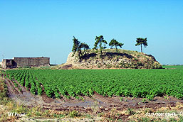
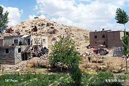
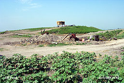
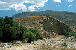
Samples from Visual Documentation of Destruction
|
|
|
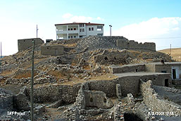 |
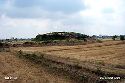
Aktil Hoyuk (mound) (K.Maras/Elbistan): c. 7000 years old. A Two-story high modern house was built on this Chalcolithic Age mound. Some old buildings (now in ruins) lie on the slopes. |
 |
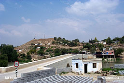
Anberinharki (mound) (Adana/Kadirli): 7000 years old. Settled in the Chalcolithic Age and then in the Early Bronze Age. The west corner was completely raze off by a road. Approximately 2/3rd of the mound was leased by the Waterworks Administration (DSI) 5 years ago. It is completely leveled. Now, the Waterworks construction site rests on it. |
 |
Çaputçu (mound) (Adana/Merkez): Discovered during a survey in 1951. A Bronze Age and Hellenistic Settlement. Village of Çaputçu is located atop the mound. Soil has been removed from the mound, which is nearly destroyed. |
 |
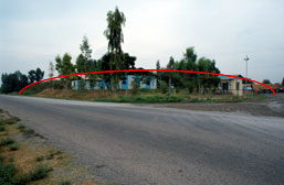
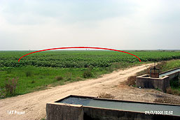
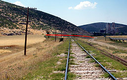
Çavuslu (mound) (Içel/Merkez): Only a remaining tiny section reveals what once was a mound. The town of Çavuslu sits atop now. The west slope is razed off by a 9 meters wide road constructed by Mersin Municipality in 2000. Originally 20 meters high, this mound is one of the three (Yumuktepe and Tirmiltepe) Early Bronze Age mounds in Mersin. |
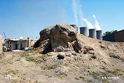 |
Çogulhan (mound) (K. Maras/Elbistan): Archaeological finds dating back to the Chalcolithic and Bronze Ages were discovered during early excavations. 97% of the site is destroyed. Houses were built on it, and soil was removed for wall plaster of mud-brick houses. Afsin-Elbistan thermoelectric power plant lies just east of the site. |
 |
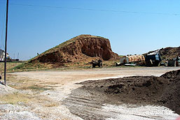
Domuz I (mound) (Adana/Karatas): Leveled in mid 1960´s by Rural Affairs Administration. There is no mound to see anymore! 5 to 6 similar sites were recorded in this region. By the way, some of the duties of the Rural Affairs Administration are to ensure appropriate utilization of agricultural lands, land leveling, construction of field channels, dirt roads, and field drainage systems... |
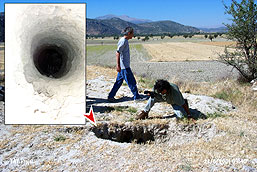 |
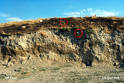
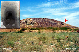
Garkin (mound) (Antalya/Korkuteli): Illicit digging and destructive agricultural activities are observed on the Early Bronze Age mound. There is a (1.70 m wide and 7.30 m deep) pit dug by treasure hunters on top of the mound. It is the one of the largest of hundreds of other pits we´ve discovered throughout these two years (see small photograph). |
 |
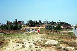
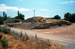
Gelendost Hoyugu (mound) (Isparta/Gelendost): c. 5000 years old. Half of the mound, dating back to the Chalcolithic and Early Bronze Age, was bought by the municipality of Gelendost for the construction of the new industry bazaar. Two foundations, 30 square meters each, were laid, and left half finished. On the right half of the mound lies apple gardens, a two-story high house, a high voltage line and treasure pits. |
 |
Gokhoyuk (mound) (Antalya/Merkez): c. 9000 years old. Soil was removed from the periphery of this Neolithic Age mound. It is terraced. The destruction of all sides of the mound still continue for the purpose of expanding the neighboring fields. |
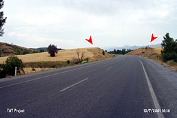 |
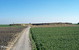
Hanvakfi Eski II (mound) (Konya/Seydisehir): c. 9000 years old. Konya-Seydisehir Highway cut the mound into two 7 years ago. Intensive agricultural activities are observed. |
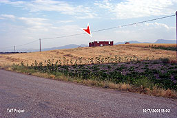 |
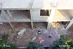
Homa (mound) (Konya/Beysehir): A house in construction (in July 2001) lies on the cultivated mound. The southern and western slopes were cut off and leveled. There is a deep treasure pit on top of the mound. A road passes through the western slope. |
 |
Kara Elbistan (mound) (K. Maras/Elbistan): A modern cemetery is located on the Early Bronze Age mound. Soil was removed from the slopes for the construction of buildings. Aggressive soil removal is so invasive that bones within the graves can be seen at the profile. |
 |
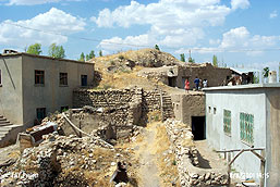
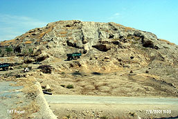
Karahoyuk Elbistan (mound) (K. Maras/Elbistan): Early Bronze Age mound, measuring 300 x 350 x 18 m in dimensions. It was excavated at the end of 1940´s. Houses lie everywhere except on the eastern side. Slopes were leveled to build the houses. There are more than 70 treasure pits. The huge pit at the very center has a name given by the locals: Nimet Deresi, meaning Bounty Creek! |
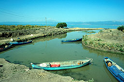 |
Kusluca (cemetery) (Konya/Elbistan): An Early Bronze Age cemetery close to the lake of Beysehir. Nature and the channel built by the fishermen have completely destroyed the site. |
 |
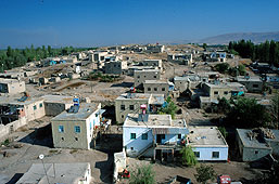
Malap (mound) (K. Maras/Elbistan): Located in the town of Bakis. The Early Bronze Age mound is destructed by contemporary settlements. Houses are built on the western, southern and northern slopes of the mound. |
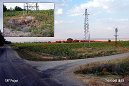 |
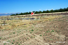
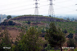
Maraba (mound) (K. Maras/Elbistan): c. 7000 years old. It was razed off by a road on the western and southern slopes, and completely destroyed by leveling for cultivation. A high voltage line is built on top of it, and it is still under the assault of treasure hunters (small photograph). |
 |
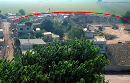
Misis (mound) (Adana/Yakapinar): A large mound that was settled in the Neolithic, Chalcolithic and Early Bronze Ages. Contemporary settlement and illegal construction activities are the causes of destruction. |
 |
Nacarli (mound) (Adana/Tarsus): c. 7000 years old. The Chalcolithic Age mound is dug by a bulldozer for treasure hunting, half of it is destroyed for cultivation, and two high voltage lines are built on top of it. The site is continually shrinking because of soil removal. |
 |
Ozan Hoyuk (mound) (K. Maras/Elbistan): The top of the mound is leveled, and all slopes are cut off. It was flatten by the new village road. A high voltage line is located on the site. |
 |
Poskoflu-Yazidere (mound) (K. Maras/Elbistan): Numerous treasure pits are recorded at the Chalcolithic and Early Bronze Age mound. In addition, a ¨treasure tunnel¨, through which a man can easily walk on foot, is found extending towards the center of the mound. |
 |
Senirce Hoyugu (mound) (Isparta/Senirce): Half of the mound is destroyed by railway. A village road and a channel passes by the sides. Treasure pits are everywhere. It is being cultivated. |
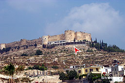 |
Silifke Kalesi (castle) (Içel/Silifke): Two-story high café/restaurant building is constructed by the municipality of Silifke in the Ottoman Castle, which was settled in the Chalcolithic and Early Bronze Ages. |
 |
Sirtlanini Magarasi (cave) (Içel/Silifke): The hill, under which the Paleolithic cave lies, is covered with modern houses. 14 years ago the mouth of the cave was blown up with dynamite, and filled with rubble. Then the drainage channels of the neighboring houses were debouched into the cave, and buildings were constructed on top of it. |
 |
Tell Afsin (mound) (K. Maras/Elbistan): A mound dating back to the Chalcolithic Age. Soil removed for the construction of mud-brick houses during the last 30 years. |
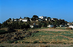 |
Tell al Terzi (mound) (Antakya/Reyhanli): Locals of Terzihoyuk built their village on top of the mound to avoid the floods. Once the village was located on the slopes, but in time, it gradually moved towards the top. |
 |
Tell Dhahab/Altintepe (mound) (Antakya/Merkez): c. 9000 years old. 4/5th of the mound soil, dating back to the Neolithic Age-Early Bronze Age, was removed to be used on the border of the highway close by. |
 |
Tell Matta (mound) (Antakya/Kirikhan): The mound is completely leveled, and used as a field. Soil is removed continuously. |
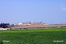 |
Tell Tayinat (mound) (Antakya/Reyhanli): A Cotton mill, built during 1950´s, lies on top of the Early Bronze Age mound. |
 |
Tell Wasfe (mound) (Antakya/Muratpasa): Soil was removed from the mound to build houses and to expand fields. It probably will be annexed to the field in a short time. |
 |
Til Hoyuk (mound) (K. Maras/Elbistan): c. 7000 years old. Various transmitters are placed on top of the Chalcolithic Age mound. A hut stands near the transmitters. A large pit was opened on the southern section for the construction of a water reservoir. Soil removal and illicit digging are also observed. All slopes are covered by modern houses. |
 |
Tulul Salihiyyah-South (mound) (Antakya/Reyhanli): Intense destruction by agricultural activities is observed. Slopes are leveled by a bulldozer. Land owners plan to level the mound completely. |
 |
Yarim Hoyuk (mound) (Burdur/Tefenni): c. 7000 years old. A unique example of a site destroyed by natural causes: The southern corner is completely destroyed by the periodic floods off the nearby creek. This settlement is probably ravaged by floods quite a few times based on its profile. |
|
|
|
 Tanindi, O. - S. Seba et al., 2002, Archaeological Destruction in Turkey, Year 2001 Preliminary Report – Meditarranean and Southeastern Anatolia Regions, TAY Project - Scientific Reports Series 8/Eng, ISBN 975-6637-07-2, İstanbul. Tanindi, O. - S. Seba et al., 2002, Archaeological Destruction in Turkey, Year 2001 Preliminary Report – Meditarranean and Southeastern Anatolia Regions, TAY Project - Scientific Reports Series 8/Eng, ISBN 975-6637-07-2, İstanbul.
|
 .. .. |
TAY Project . Kuruçesme Cad. 67/B
34345 Kurucesme Istanbul Turkey
Tel: +90 (212) 265 7858 - Fax: +90 (212) 287 1298
e.mail: info@tayproject.org |
| Copyright©1998 TAY Project |
|
|