| ©The Archaeological Settlements of Turkey - TAY Project | ||||||
|
|
||||||
Mezraa Höyük |
||||||
|
|
||||||
| Ages | Maps | Photos | ||||
| Chalcolithic EBA IA |
 |
 |
||||
|
|
||||||
|
Type:
|
Mound | |||||
|
Altitude:
|
490 m | |||||
|
Diameter:
|
m- Direction: | |||||
|
|
||||||
|
Region:
|
Southeastern Anatolia | |||||
|
Province:
|
Sanliurfa | |||||
|
District:
|
Birecik | |||||
|
Village:
|
Mezraa | |||||
|
|
||||||
|
|
||||||
|
|
||||||
|
TAYEx:
|
Visited - 14/8/2001 | |||||
|
|
||||||
|
Registration State:
|
For detailed registration information please refer to Turkish pages. | |||||
 |
||||||
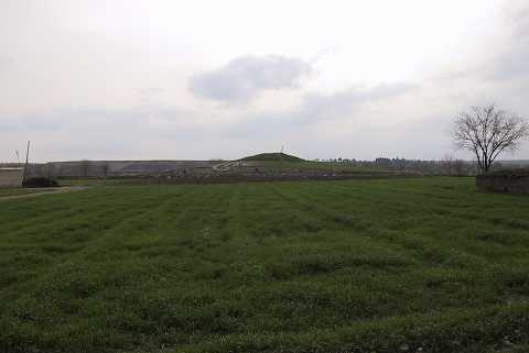
| Location: Mezraa Höyük is located southwest of Sanliurfa; 7 km south of the town of Birecik as the crow flies and 1.5 km southeast of Mezraa. |
| Geography and Environment: Mezraa Höyük is on a terrace of the flood plain of the Euphrates; approximately 335 m above the sea level and rises 13 m above the plateau where today vegetables and cotton are grown. The mound extends approximately 180 m from north to south and 140 m from east to west. Earth has been removed from an area of about 40 m at the east end of the mound in order to extend the agricultural land. The remains belonging to several phases of occupation are visible in the section that has been created here. The steep west slope of the mound and gentler north slope have been damaged by both erosion and agricultural activities [Ökse-Tekinalp 1999:175]. |
| Destruction Details: |