|
©The Archaeological Settlements of Turkey - TAY Project
|
|
|
|
|
|
Mezraa Höyük |
|
|
For site maps and drawings please click on the picture... 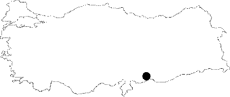 |
For photographs please click on the photo... 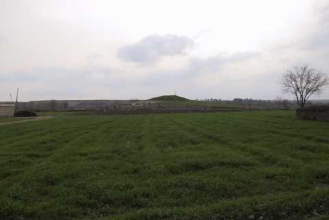 |
|
Type:
|
Mound |
|
Altitude:
|
490 m |
|
Region:
|
Southeastern Anatolia |
|
Province:
|
Sanliurfa |
|
District:
|
Birecik |
|
Village:
|
Mezraa |
|
Investigation Method:
|
Excavation |
|
Period:
|
New Assyrian Empire Period |
|
|
|
 |
|
| Location: Mezraa Höyük is located southwest of Sanliurfa; 7 km south of the town of Birecik as the crow flies and 1.5 km southeast of Mezraa. |
| Geography and Environment: Mezraa Höyük is on a terrace of the flood plain of the Euphrates; approximately 335 m above the sea level and rises 13 m above the plateau where today vegetables and cotton are grown. The mound extends approximately 180 m from north to south and 140 m from east to west. Earth has been removed from an area of about 40 m at the east end of the mound in order to extend the agricultural land. The remains belonging to several phases of occupation are visible in the section that has been created here. The steep west slope of the mound and gentler north slope have been damaged by both erosion and agricultural activities [Ökse-Tekinalp 1999:175]. |
| History: |
| Research and Excavation: The mound was discovered during the surveys conducted between 1987 and 1990 by G. Algaze and his team within the area that would be flooded by the water reservoir of the Karkamis Dam [Algaze et al. 1994:48, drawing 7, no. 51]. Later on, it was investigated in 1998-99 during the surveys carried out with the support of ODTÜ-TAÇDAM [Ökse-Tekinalp 1999:175-190; Ökse et al. 2001]. Salvage excavations were initiated in 2000 under the direction of D. Yalcikli and M. Tekinalp on behalf of the Archaeological Museum of Sanliurfa with the support of ODTÜ TAÇDAM. |
| Stratigraphy: The excavations revealed that the site had been uninteruptedly inhabited from the late 4th Millennium BC until the mid-2nd Millennium BC. Both surveys and excavations in the northwestern slopes provided evidence for presence of the Iron Age and Middle Bronze Age levels. No trace of periods following the Iron Age was observed, and it appears that it was re-occupied during the 11th-12th centuries AD after such a long gap [Yalçikli-Tekinalp 2004a:124]. |
| Small Finds: Architecture: The northwestern section yielded a building level from the Iron Age, which has been destroyed by the Middle Age levels. In that level, a floor composed of the architectural remains belonging to the EBA, and two walls delimiting the western and northern sections of this floor were uncovered. On the northern end of the west wall was a doorjamb stone. The aperture between the north and west walls should have been for a gate opening. The building of this structure extends towards the east, which has not been excavated yet. A round hearth and a stand for pots made of compressed soil were uncovered on the stone floor of the structure. Very restricted number of finds was recovered from the level that was intensely destroyed by the Medieval levels. Pottery: Two surface finds collected during the 1999 campaign indicate presence of a potential Iron Age settlement from 9th to 7th century BC, which was not identified within the stratification in the profile of the eastern terrace at Mezraa Höyük. Similar examples of the jug with T-shaped thickened rim and cylindrical neck, wheelmade, fired at high temperature and amorphously, fine sand and a little fine clay tempered, greenish beige paste, and mat slipped ware uncovered in the area no. 646 near the eastern profile were also found at Sultantepe Tell Afis and Khirbet Qasrij. Leg fragment of a basalt vessel recovered from the Area G on the northern skirt belongs to a tripodal bowl-shaped vessel. The leg fragment with a smooth outer surface and a curved inner surface is parallel to the basalt bowl with tripod legs at the Aramaean-Neo Assyran layer of Tell Halaf, Hama E and Khirbet Qasrij [Ökse et al. 2001:196-197]. Clay: Among the finds dating to the Iron Age is fragment of a terracotta votive plaque with a female depiction. Similar of this type of terracotta votive plaques are known from Mezraa Teleilat, Harabebezikan and Saraga Höyük as well as the Iron Age levels of Tell Sheikh Hassan, Ras Samra,Tell Matsuma and Ain Dara [Yalçikli-Tekinalp 2004b:378]. Figurine: The same structure also yielded statue of a soldier head. Similar of these soldier heads is again known from Mezraa-Teleilat. Given this statue along with the terracotta votive plaque, it is believed that this level might have belonged to the Iron Age [Yalçikli-Tekinalp 2004b:378]. |
| Remains: |
| Interpretation and Dating: The excavations in 1999 focused on the eastern terrace of the mound. Two surface finds collected during the 1999 campaign indicate presence of an Iron Age settlement from 9th to 7th century BC, which was not identified within the stratification in the profile of the eastern terrace at Mezraa Höyük. |