|
©The Archaeological Settlements of Turkey - TAY Project
|
|
|
|
|
|
Mezraa Höyük |
|
|
For site maps and drawings please click on the picture...  |
For photographs please click on the photo... 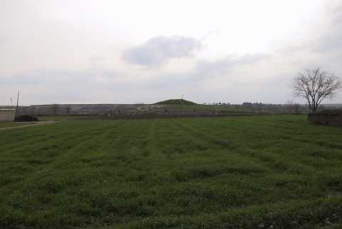 |
|
Type:
|
Mound |
|
Altitude:
|
490 m |
|
Region:
|
Southeastern Anatolia |
|
Province:
|
Sanliurfa |
|
District:
|
Birecik |
|
Village:
|
Mezraa |
|
Investigation Method:
|
Excavation |
|
Period:
|
Late |
|
|
|
 |
|
| Location: Mezraa Höyük is located southwest of Sanliurfa; 7 km south of the town of Birecik as the crow flies and 1.5 km southeast of Mezraa. |
| Geography and Environment: Mezraa Höyük is on a terrace of the flood plain of the Euphrates; approximately 335 m above the sea level and rises 13 m above the plateau where today vegetables and cotton are grown. The mound extends approximately 180 m from north to south and 140 m from east to west. Earth has been removed from an area of about 40 m at the east end of the mound in order to extend the agricultural land. The remains belonging to several phases of occupation are visible in the section that has been created here. The steep west slope of the mound and gentler north slope have been damaged by both erosion and agricultural activities [Ökse-Tekinalp 1999:175]. |
| History: |
| Research and Excavation: Mezraa Höyük was first investigated by Guilermo Algaze and his team in 1989; during the surveys in the Carchemish Dam region. The evidence indicated that he site was settled from the EBA II-III to MBA I; after which it was abandoned until the Iron Age; occupation continuing through the Hellenistic; Roman and Byzantine periods. During these times the size of the settlement was approximately 0.5 hectare. In 1998-99; researches carried out by A. Tuba Ökse and V. Macit Tekinalp during the Salvage Project of the Archaeological Heritage of the Ilisu and Carchemish Dam Reservoirs coordinated by METU TAÇDAM. The material collected in 1998 researches showed that the site could have a more earlier settlement so there made a detailed surface survey in 1999 and recorded the stratigraphy of the east terrace by closely examining its east section; exposed by the removal of soil. The aim of the excavation made by Derya Yalcikli and V. Macit Tekinalp during 2000-2002 was to uncover the levels of the periods identified in the surveys that had been carried out and record the architectural features as well as the settlement structure. The excavation focused on two areas; firstly; the terrace section at the top of the mound that had been investigated in 1999; and the east slope; where a large amount of Medieval pottery had been collected; secondly; the southeast slope; where the abundance of EBA pottery suggested that no levels of later period existed here [Ökse-Tekinalp 2002:159]. |
| Stratigraphy: Excavations made in two different areas on the east slope and the southeast slope. There are seven (I-VII) building levels on the east slope and six (I-VI) building levels on southeast slope. It has been determined that the early periods on the east slope of Mezraa Höyük were covered by the Medieval levels I-III. In this area; levels dating to the second half of the 3rd Millennium BC were revealed beneath levels IV-V belonging to the first quarter of the 2nd Millennium. Beneath the 3rd Millennium levels II and III on the southeast slope; which had been damaged by the Medieval silos of level I; were exposed levels IV and V; dating to the first half of the 3rd Millennium. Level VI; below these; can be dated to the end of the 4th Millennium. The excavations on the southeast slope indicate that there was unbroken settlement at this part of the mound from the end of the 4th Millennium through to the second half of the 3rd Millennium BC [Yalçıklı-Tekinalp 2002:205-206]. The results of the 2000 excavation season suggested that while eastern slope was densely settled during the Medieval Period; there was no settlement on the southeastern slope; this area was used only for grain silos. The excavations on the south east slope indicate that there was unbroken settlement at this part of the mound from the end of the 4th through to the second half of the 3rd Millennium BC [Yalçıklı-Tekinalp 2002:206]. |
| Small Finds: Architecture: The architectural remains belonging to the EBA and Late Chalcolithic found in building levels II-VI at the excavations on southeast slope. In building level VI found a fill formed from small stones and after digging deeper for 10 cm; no architectural remains were discovered; only pottery sherds were found in this area [Yalçıklı-Tekinalp 2002:192]. This material found in a very limited area whose architectural features have not been uncovered indicates that there was an important Late Chalcolithic/Late Uruk settlement in this part of the mound [Yalçıklı-Tekinalp 2002:205]. Pieces of a wall and base that are destructed and showing no signs of integrity are unearthed in Architecture Layer IX [Yalçõklõ-Tekinalp 2011: 127] Pottery: The material from level VI dated to Late Chalcolithic; were divided into two fabric groups. One of them is gritty ware represented by fragments made of a paste with a medium amount of sand; lime and large grit particles; colors reddish brown and cream; wheel-made and burnished. Parallels are known from Habuba Kabira and Hacı Nebi. The other is chaff-faced ware; made of a yellowish green paste containing large grit particles and a high amount of chaff temper [Yalçıklı-Tekinalp 2002:205]. A piece of pottery which was among the pieces captured in Architecture Layer IX is extraverted rimmed and large bodied [Yalçõklõ-Tekinalp 2011: 127]. |
| Remains: |
| Interpretation and Dating: Although only the second season of the excavation has been completed; it is reported that the site has yielded evidence for a continuous settlement from the Late Chalcolithic to the end of the Middle Bronze Age. According to the ceramic finds; it is believed that there was a Late Chalcolithic/Late Uruk settlement in Mezraa Höyük. |