| ©The Archaeological Settlements of Turkey - TAY Project | ||||||
|
|
||||||
Saraga |
||||||
|
|
||||||
| Ages | Maps | Photos | ||||
| Chalcolithic EBA IA |
 |
 |
||||
|
|
||||||
|
Type:
|
Mound | |||||
|
Altitude:
|
520 m | |||||
|
Diameter:
|
m- Direction: | |||||
|
|
||||||
|
Region:
|
Southeastern Anatolia | |||||
|
Province:
|
Gaziantep | |||||
|
District:
|
Karkamis | |||||
|
Village:
|
Kelekli | |||||
|
|
||||||
|
Destruction :
|
Dams - Natural causes - Agriculture | |||||
|
|
||||||
|
TAYEx:
|
Visited - 11/8/2001 | |||||
|
|
||||||
|
Registration State:
|
Registered For detailed registration information please refer to Turkish pages. | |||||
 |
||||||
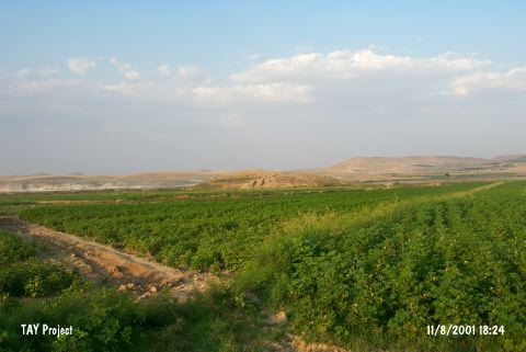
| Location: Saraga is located on the west bank of the Euphrates; about 800 m northeast of the village of Keleklioglu; in the Karkamis district of the province of Gaziantep. The village is reached by an asphalt road that runs parallel to the river after leaving the Gaziantep-Urfa highway at Birecik. The mound is 10 km north of the ancient site of Carchemish. The sites of Gre Virike; Akarçay Tepe and Akarçay Höyük are all opposite of Saraga; on the east bank of the river. |
| Geography and Environment: A small stream with its source in the foothills of the Nizip Plateau runs into the Euphrates just south of the mound. The mound extends 200 m north-south and 150 m east-west; and is approximately 22 m high. Apart from the natural section created by the Euphrates on the northeast; all skirts of the mound have been cut back in order to create agricultural land and for road construction. |
| Destruction Details: The north slope and west skirt of the mound are leveled for agricultural activities. Soil taken from south and west slopes of the mound and Euphrates surrounds it in all south; east and north directions. The archaeological excavations continue on the mound and some of the trenches are under water [TAYEx 11.8.2001]. |