|
©The Archaeological Settlements of Turkey - TAY Project
|
|
|
|
|
|
Saraga |
|
|
For site maps and drawings please click on the picture...  |
For photographs please click on the photo... 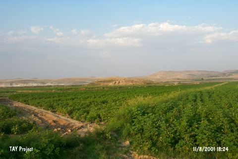 |
|
Type:
|
Mound |
|
Altitude:
|
520 m |
|
Region:
|
Southeastern Anatolia |
|
Province:
|
Gaziantep |
|
District:
|
Karkamis |
|
Village:
|
Kelekli |
|
Investigation Method:
|
Excavation |
|
Period:
|
Late |
|
|
|
 |
|
| Location: Saraga is located on the west bank of the Euphrates; about 800 m northeast of the village of Keleklioglu; in the Karkamis district of the province of Gaziantep. The village is reached by an asphalt road that runs parallel to the river after leaving the Gaziantep-Urfa highway at Birecik. The mound is 10 km north of the ancient site of Carchemish. The sites of Gre Virike; Akarçay Tepe and Akarçay Höyük are all opposite of Saraga; on the east bank of the river. |
| Geography and Environment: A small stream with its source in the foothills of the Nizip Plateau runs into the Euphrates just south of the mound. The mound extends 200 m north-south and 150 m east-west; and is approximately 22 m high. Apart from the natural section created by the Euphrates on the northeast; all skirts of the mound have been cut back in order to create agricultural land and for road construction. |
| History: |
| Research and Excavation: The mound was first discovered in 1989 by a team under the leadership of G. Algaze. It was surveyed by the Museum of Gaziantep in 1998; during the METU TAÇDAM Salvage Project of the Archaeological Heritage of the Ilisu and Carchemish Dam Reservoirs. In 1999 and 2000; salvage excavations were conducted under the co-direction of K. Sertok (Gaziantep Museum) and F. Kulakoğlu (University of Ankara; Faculty of Languages; History and Geography) as a part of the same project. It takes place in the registered archaeological sites list prepared by Ministry of Culture and Tourism. |
| Stratigraphy: The settlement has yielded layers belonging to Late Uruk; Early Bronze Age; Middle Bronze Age; Late Bronze Age; Iron Age and the Medieval ages. While EBA is represented by three phases; at least two phases were determined for MBA. A specific change indicating the transition between the Middle and Late Bronze ages was not found. The Iron Age materials were encountered immediately beneath the surface. The cultural layers of the Medieval ages were located on the southern trenches. |
| Small Finds: Architecture: In trench K; a plastered conical hollow that probably once contained a jar; and severely burned plaster fragments were found preserved on the floor. The level these finds were reached is virtually the same as the present level of the Euphrates. This shows that the bed of the river was lower during the Late Uruk and the earlier periods than it is today. During this stage of excavation; the water table was reached and the trench was flooded by the water of the dam reservoir. Because of this situation; it was not possible to reach the earliest settlement levels of the site [Sertok-Kulakoglu 2001:477-478]. Pottery: Chaff tempered bevelled rim bowls and narrow spouts with down-turned ends indicate the existence of a Late Uruk settlement on the mound [Sertok-Kulakoglu 2001:477]. The 2000 season excavations were carried out only in the Middle and Late Bronze Age levels. However; in a small area outside the main wall of a Late Bronze Age building were found four sherds of pottery with reserved slip; which was probably brought from lower layers for preparing the floor of a hearth. All four of these sherds are thick walled; belonging to large wheel-made storage jars; with a fabric color ranging from light brown to red. The basic decoration consists of diagonal bands; but some examples have a horizontal line on the shoulder and bands divided by vertical lines on the interior. One sherd is decorated on the shoulder with a horizontal row of incised dots. This ware group is one of the defining traits of the Late Uruk Period and the early part of the Early Bronze Age in the area from Lower Mesopotamia to the Zagros Mountains and Eastern Anatolia. Even though the Saraga examples were not found in their original context; they are still significant to reinforce the existence of a settlement in that period on the mound [Sertok-Kulakoglu 2002a: 376;377]. |
| Remains: |
| Interpretation and Dating: As a result of the excavations; a settlement with a sequence from the Late Uruk period to the Medieval ages. The Late Uruk layers; which were only reached in one soundage in 1999 season; were supported by the sherds with reserved slip that characterize the Late Uruk/Early Bronze Age. Algaze compared the Late Uruk settlements of Tiladir; Sadi Tepe; Kumtepe and Komeçli; in the near vicinity of Saraga; with the sites of Habuba Kabira; Cebel Aruda and Tell Kannas; in the Tabka Dam basin; and described them as centers of a "colony system" settled by Uruk groups engaged in business dealings in this part of the Euphrates Region. The settlements in the region at which there is evidence of Late Uruk culture are not limited to these centers; but show a much denser distribution. The excavation finds from Saraga; unfortunately; are inadequate to explain the part played by the site within this Late Uruk system. However; in contrast to the sites mentioned above; where occupation ceased with the collapse of this system; the settlement at Saraga continued in existence [Sertok-Kulakoglu 2001:483;484]. |