| ©The Archaeological Settlements of Turkey - TAY Project | ||||||
|
|
||||||
Seydiler |
||||||
|
|
||||||
| Ages | Maps | Photos | ||||
| Neolithic Chalcolithic EBA IA |
 |
 |
||||
|
|
||||||
|
Type:
|
Mound | |||||
|
Altitude:
|
1210 m | |||||
|
Diameter:
|
m- Direction: | |||||
|
|
||||||
|
Region:
|
Mediterranean | |||||
|
Province:
|
Burdur | |||||
|
District:
|
Tefenni | |||||
|
Village:
|
Seydiler | |||||
|
|
||||||
|
Destruction :
|
Illicit Digging - Agriculture | |||||
|
|
||||||
|
TAYEx:
|
Visited - 14/6/2001 | |||||
|
|
||||||
|
Registration State:
|
For detailed registration information please refer to Turkish pages. | |||||
 |
||||||
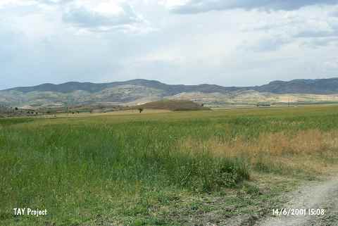
| Location: It lies 1.6 km northwest of Seydiler Village; southeast of Tefenni District of Burdur Province. A dirt road passes 150 east of the mound. In some publications; it is called Seydiler Höyük. |
| Geography and Environment: The mound lies in the southwestern corner of the Tefenni Plain; which was a swamp until recently. On the northern flanks of Mount Bölükler; only 100 m south of the site; is a spring known as Kocapinar. The inhabitants of this site must have used this spring as a water source. Özsait reports that this medium-sized mound is 10 m high and 120 m east-west. Especially the western and northern flanks of the mountain have faced damage. The sides of the mound are not very steep [Özsait 1986b:fig 7]. |
| Destruction Details: The mound has been damaged due to agricultural activities and illicit diggings. The pit on top hill measuring 2x5 m extends towards the other pits on southern slope. The leveled part on eastern slope and all of the skirts are being cultivated [TAYEx 14.6.2001]. |