|
©The Archaeological Settlements of Turkey - TAY Project
|
|
|
|
|
|
Seydiler |
|
|
For site maps and drawings please click on the picture...  |
For photographs please click on the photo... 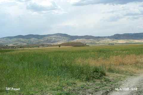 |
|
Type:
|
Mound |
|
Altitude:
|
1210 m |
|
Region:
|
Mediterranean |
|
Province:
|
Burdur |
|
District:
|
Tefenni |
|
Village:
|
Seydiler |
|
Investigation Method:
|
Survey |
|
Period:
|
|
|
|
|
 |
|
| It lies 1.6 km northwest of Seydiler Village; southeast of Tefenni District of Burdur Province. A dirt road passes 150 east of the mound. 100 m south lies the Bölükler Tepesi; 1193 m high where there is a well spring called Kocapinar on the northern foothill. It measures 10 m in height and 100x200 m in dimensions. It was first investigated by J. Mellaart and dated to the Late Chalcolithic Age. The survey conducted by M. Özsait in 1984 yielded pottery of the EBA; the Late and Early Chalcolithic Ages. |
| Location: It lies 1.6 km northwest of Seydiler Village; southeast of Tefenni District of Burdur Province. A dirt road passes 150 east of the mound. In some publications; it is called Seydiler Höyük. |
| Geography and Environment: The mound lies in the southwestern corner of the Tefenni Plain; which was a swamp until recently. On the northern flanks of Mount Bölükler; only 100 m south of the site; is a spring known as Kocapinar. The inhabitants of this site must have used this spring as a water source. Özsait reports that this medium-sized mound is 10 m high and 120 m east-west. Especially the western and northern flanks of the mountain have faced damage. The sides of the mound are not very steep [Özsait 1986b:fig 7]. |
| History: |
| Research and Excavation: |
| Stratigraphy: |
| Small Finds: |
| Remains: |
| Interpretation and Dating: |