| ©The Archaeological Settlements of Turkey - TAY Project | ||||||
|
|
||||||
Oylum Höyük |
||||||
|
|
||||||
| Ages | Maps | Photos | ||||
| Chalcolithic EBA IA |
 |
 |
||||
|
|
||||||
|
Type:
|
Mound | |||||
|
Altitude:
|
848 m | |||||
|
Diameter:
|
m- Direction: | |||||
|
|
||||||
|
Region:
|
Southeastern Anatolia | |||||
|
Province:
|
Kilis | |||||
|
District:
|
Merkez | |||||
|
Village:
|
Oylum | |||||
|
|
||||||
|
Destruction :
|
Contemporary Settlements - Attention | |||||
|
|
||||||
|
TAYEx:
|
Visited - 23/8/2001 | |||||
|
|
||||||
|
Registration State:
|
Registered For detailed registration information please refer to Turkish pages. | |||||
 |
||||||
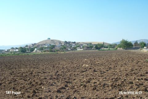
| Location: The site lies 7 km south-southeast of Kilis; south of Gaziantep highway; right next to the village of Oylum. Southern slope; skirts and a part of the southeastern slope of the mound is occupied by the modern village and there are large sections due to the exercise of taking away soil on its eastern and western slopes and skirts [Özgen 1987:241; Özgen et al. 1997:42]. |
| Geography and Environment: The site lies at the intersection point of Euphrates Valley and Amuq Plain in East-West axis and of Northern Syria and Anatolian Plateau in North-South axis. The region has a central value because of the mild climate of Kilis Plain in the prehistoric era and of its geopolitical position in the Bronze Ages. West of the mound is the recently dried Akpinar Stream which has a low water level in seasons of heavy rain. The 460x320 m mound consists of two cones: the 22 m high northern mound and the 37 m high southern mound with a defile connecting the two. |
| Destruction Details: There are mudbrick houses on west and east slopes of the mound and a big amount of soil has been taken from this part. There are village houses on all slopes and the skirts of the site are terraced by a road. There is a grave on the southern cone of the mound [TAYEx 23.8.2001]. |