|
©The Archaeological Settlements of Turkey - TAY Project
|
|
|
|
|
|
Oylum Höyük |
|
|
For site maps and drawings please click on the picture...  |
For photographs please click on the photo... 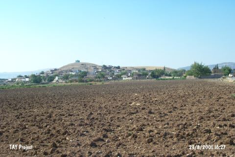 |
|
Type:
|
Mound |
|
Altitude:
|
848 m |
|
Region:
|
Southeastern Anatolia |
|
Province:
|
Kilis |
|
District:
|
Merkez |
|
Village:
|
Oylum |
|
Investigation Method:
|
Excavation |
|
Period:
|
Middle Late |
|
|
|
 |
|
| Location: The site lies 7 km south-southeast of Kilis; south of Gaziantep highway; right next to the village of Oylum. Southern slope; skirts and a part of the southeastern slope of the mound is occupied by the modern village and there are large sections due to the exercise of taking away soil on its eastern and western slopes and skirts [Özgen 1987:241; Özgen et al. 1997:42]. |
| Geography and Environment: The site lies at the intersection point of Euphrates Valley and Amuq Plain in East-West axis and of Northern Syria and Anatolian Plateau in North-South axis. The region has a central value because of the mild climate of Kilis Plain in the prehistoric era and of its geopolitical position in the Bronze Ages. West of the mound is the recently dried Akpinar Stream which has a low water level in seasons of heavy rain. The 460x320 m mound consists of two cones: the 22 m high northern mound and the 37 m high southern mound with a defile connecting the two. |
| History: |
| Research and Excavation: The researches conducted in this region have started in the beginning of the 20th Century. J. Garstang; B. Hrozny; and M.V. Seton-Williams; P. van der Meer; and C. Hillen are the scholars who have conducted excavations and surveys in the region between Gaziantep and Halep; in the fifties. The exceptional importance of Oylum Höyük was first emphasized by U.B. Alkim during his research in Islahiye Plain followed by the research of the Italian Team. The first scientific survey of the mound is conducted in 1985 by E. Özgen. The excavations have started in 1987 as a joint project of Hacettepe University and Gaziantep Archaeology Museum and are still being conducted by E. Özgen as a joint project of Hacettepe University and the Istanbul German Archaeological Institute since 1990 [Özgen 1987:241; 1990b:22; Özgen et al. 1997:40-42]. The excavations were carried out on the southern and northern elevations; the damaged area and the steep slope in the northeast. The 2009 studies were carried out between 01.07.2009-31.08.2009 by E. Özgen and his team. The studies continued on the northwest ridge of the mound. The goal of the studies that have been continuing since 2007 is to search the Bronze Ages in detail since the settlement was a regional center during this period and to reveal the stratigraphy. Within the scope of the fieldwork, the studies were conducted in 8 different trenches measuring 10x10 m on the northwest ridge of the mound. In this area, the studies were carried out in Trench L21, M21 and M22 that were opened in previous seasons and also in Trench J21, J22, K21, K22 and L22 [Özgen et al. 2011: 56]. It takes place in the registered archaeological sites list prepared by Ministry of Culture and Tourism. |
| Stratigraphy: The site has been settled continuously from Chalcolithic Age to Hellenistic Period. The sherds collected from the southern slope represent the Roman Period. Hellenistic Period remains are recovered in the northeastern and southwestern trenches close to the highest section of the mound and it is concluded that during the following Iron Age levels; settling is rather intense at the north and on the eastern slope. The trench in eastern slope yields stratified Bronze Age architectural remains. The earliest finds of the mound come from the Chalcolithic Age level for now; recovered in the sounding (Z 7a) dug at plain level at the northeast. It is concluded in the last seasons' work; therefore; that the rich Bronze and Iron Age settlements of Oylum Höyük are founded upon a Chalcolithic Age (Ubaid Culture) settlement. Virgin soil has not been met; yet [Özgen et al. 1996:186; Özgen et al. 1997:44-45; 63]. |
| Small Finds: Architecture: A small; round; mud-brick fitment and a limestone used probably as a grinding stone in the middle of it were recovered in the sounding (Z 7); in the area; damaged due to taking away soil by the villagers; at the northeast of the mound. This level has a burnt; ashy deposit. The deposit below this level is on a pavement of sherds and pebbles and yields sherds and sling stones [Özgen et al. 1997:63]. It is suggested that the conflagrated mud-brick walls recovered during the levelling of the sections; during the first seasons of excavation in the "East Destruction Area" at the east of the mound; date back to Chalcolithic/Early Bronze Age [Özgen et al. 1990a:204]. During 2002 season excavations in plan square ZAA 11; 3rd building phase of the Late Uruk Period building units which showed a long time occupation and were having multi-phases in the same plan was uncovered. The floor of the room was plastered by was built by single line mudbricks on rubble stones and its floor was covered with lime. Burials were uncovered under this floor. A pit with animal bones and pebbles found at the area south of the building wall [Özgen et al. 2004:340]. Pottery: The Chalcolithic Age ceramic assemblage of the mound is grouped in three kinds of ware. The chaff and grit-tempered coarse ware with surface colors ranging between brown and reddish-brown is the first group. The second is the sand-tempered standard ware; with painted and non-painted variants. The prefered surface colors of the non-painted subgroup are shades of beige ranging from yellowish to greenish and shades of red-brown. The painted kind consists of three subgroups: the dominant surface color of the monochrome matt painted are brown and greenish brown; the polichrome are painted in red and black; and the third subgroup is the fine painted ware. White paint is used rarely. The painted decoration motifs are irregular wavy bands and hatched metops; zig-zags; and chains arranged as either single motifs or in horizontal bands. The third kind of ware is non-tempered; plain; light colored; fine ware. These are hardly fired and highly burnished. The dominant forms are conical vessels; bowls; and short-necked jars with sharp profiles [Özgen et al. 1997:63-64]. Clay: Sling pallets out of clay are recovered in the Chalcolithic Age deposit [Özgen et al. 1997:63]. Clay balls were found nearby the pit uncovered in plan square ZAA 11. These unfired clay balls are suggested to be used for stamping; but there are no stamp impressions on them [Özgen et al. 2004:340]. Human Remains: One simple burial of a man in hocker position is recovered during the cleaning and levelling of the "East Destruction Area". The skeleton is ill-preserved below waist and it belongs to a man; from the Mediterraenean race; of age 25-30. The burial gifts are a blade put next to his shoulder and numerous flint stones. The finds suggest that the burial is dated to the end of the Chalcolithic Age and the very beginning of the Early Bronze Age [Özgen 1990a:204]. During the removal of the floor in plan square ZAA 11 two infant burials in jars were found nearby the wall. An other infant burial was located near the door [Özgen et al. 2004:340]. Flora: The floral research has revealed that the main food source were grains; wheat having the first place. Besides; peas; lentil; fig; grapes; some vegetables; and weeds were being gathered and consumed [Pasternak 1997:69]. |
| Remains: |
| Interpretation and Dating: The Chalcolithic Age finds of Oylum Höyük; especially the painted pottery is compared with Tell Kurdu (Amuq E); Gedikli Höyük (Level III); and Sakçagözü settlements of the same region [Özgen et al. 1997:64]. |