|
©The Archaeological Settlements of Turkey - TAY Project
|
|
|
|
|
|
Oylum Höyük |
|
|
For site maps and drawings please click on the picture...  |
For photographs please click on the photo... 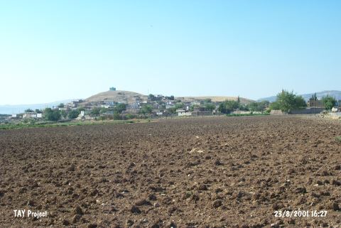 |
|
Type:
|
Mound |
|
Altitude:
|
848 m |
|
Region:
|
Southeastern Anatolia |
|
Province:
|
Kilis |
|
District:
|
Merkez |
|
Village:
|
Oylum |
|
Investigation Method:
|
Excavation |
|
Period:
|
EBA III EBA I |
|
|
|
 |
|
| Location: The site lies 7 km south-southeast of Kilis; south of Gaziantep highway; right next to the village of Oylum. Southern slope; skirts and a part of the southeastern slope of the mound is occupied by the modern village and there are large sections due to the exercise of taking away soil on its eastern and western slopes and skirts [Özgen 1987:241; Özgen et al. 1997:42]. |
| Geography and Environment: The site lies at the intersection point of Euphrates Valley and Amuq Plain in East-West axis and of Northern Syria and Anatolian Plateau in North-South axis. The region has a central value because of the mild climate of Kilis Plain in the prehistoric era and of its geopolitical position in the Bronze Ages. West of the mound is the recently dried Akpinar Stream which has a low water level in seasons of heavy rain. The 460x320 m mound consists of two cones: the 22 m high northern mound and the 37 m high southern mound with a defile connecting the two. |
| History: |
| Research and Excavation: The researches conducted in this region have started in the beginning of the 20th Century. J. Garstang; B. Hrozny; and M.V. Seton-Williams; P. van der Meer; and C. Hillen are the scholars who have conducted excavations and surveys in the region between Gaziantep and Halep; in the fifties. The exceptional importance of Oylum Höyük was first emphasized by U.B. Alkim during his research in Islahiye Plain followed by the research of the Italian Team. The first scientific survey of the mound is conducted in 1985 by E. Özgen. The excavation project was launched as a joined effort of Gaziantep Museum and Hacettepe University in 1987. From 1990 to 2012, E. Özgen led the project on behalf of the Hacettepe University and German Archaeological Institute in Istanbul as partners. [Özgen 1987:241; 1990b:22; Özgen et al.1997:40-42]. The excavations were carried out on the southern and northern elevations; the damaged area and the steep slope in the northeast. The tortoise shells and potsherds found in 12 pits at EBA III layers, which were uncovered in the middle of the north excavation area in 2007 season estimated as the remains of a collective ceremony devoted to life and fertility, especially when it was considered that the pits were carefully covered in a sense they were sealed after use. Depending on the presence of tortoise shells in the pits, it could be said that they had been used as musical instruments or symbols in rituals related to life and fertility. The special usage and fertility related symbolic use of tortoise shell known from Nevali Çori PPNB layers and Late Neolithic Kortik Tepe in Anatolia. Sea turtle shells about all of them preserved also found in PPNB layers of Akanthou - Arkosykos / Tatlisu Çiftlikdüzü in Cyprus. In Aegean region, the different usage of tortoise shells only known from Mycenae City / Sanctuary Phylakopi in Melos so far [Erkanal et al. 2009:306-307]. Since 2013, the excavations have been carried out by a team led by A. Engin. Oylum Höyük is listed as an officially registered archaeological site by the Ministry of Culture and Tourism. |
| Stratigraphy: Both the survey and the excavations revealed that the site had been inhabited from the Chalcolithic Age to the Hellenistic Period; probably resulting from the fact that the site of Oylum Höyük was located on a trade road. The layers continue downwards from the Hellenistic; Classical and Archaic Periods. Layers of the first and second millennia BC were separated from the Chalcolithic Age layers by a thick EBA layer. Altough; the excavation is not complete yet; stratification of the EBA layer has been partly laid out at the stepped trench on the northeastern slope. Out of the 4 building levels uncovered through the trench Z IIa; levels 2-4 are dated to the EBA IV (?) (transition period) by the excavator. A chamber grave uncovered underneath exposes that the cemetery is datable to EBA III or IV while the big pithos graves are tended to be dated to EBA IV/transition from EBA to MBA. The building levels 5 and 6 out of the six building levels uncovered at the damaged northeastern section are dated to EBA III while the upper levels to EBA IV [Özgen-Carter 1991:260-265]. The floor of the damaged area yielded building levels of the Chalcolithic Age (Please see Harmankaya et al. 1991:Oylum). The virgin soil was not reached yet. There is a step trench on eastern slope, which the excavations continue since 1993. The primary objective of this work is researching the stratigraphy on Oylum Höyük. This trench extends on lots of steps at W-X-Y-Z 11 surfaces. The early period 3rd millennium layers reached at the bottom step Z11b. Studies focused on the floors of Middle Bronze Age building levels at Y11 step trench in passed two years. After the important buildings became visible at this location, the excavation area extended towards the connection surfaces of step trenches Y10, Y9 and X9. This would help understanding the Middle Bronze Age architecture at this location. An important outcome of two excavation seasons was that the big part of Early Bronze Age section, which slides northeast across the Middle Bronze Age section was vanished due to erosion. On the western slope of this older mound after a longtime hiatus, a Late Bronze Age structure built on the terraced area. This meant that the stratigraphic sequence was not complete at this part of the slope. |
| Small Finds: Architecture: The building levels of EBA consist of mudbrick structure on a stone socle. The walls are plastered and whitewashed. An exact plan was not obtained; probably due to the confined excavation area. Also found are white painted floors [Özgen et al. 1997:194]. Pottery: No detailed information was provided about the upper building levels of EBA while the lower levels yielded sherds of Karaz ware [Özgen et al. 1996:185].. Human Remains: It was noted that the northeastern part of the mound was used as a cemetery next to the settlement at the end of the third millennium BC and second millennium BC. The chamber grave; "Grave of Vases"; recovered and robbed during the illicit digging carried out by the local villagers in 1986 was informed to measure 190x125 cm in dimensions and 2 m in depth. Its side walls were erected by plate stones and the top was covered by white flat stone plates. Apart from the hundreds of cups left as grave goods; two shaft-holed bronze axes; one broken [Özgen 1990b:205]; bronze bracelet; earring and necklace; semi-circular pins; needles; silver earrings were recovered [Özgen 1989:96; pic.4]. The villagers handed most of these finds they plundered over to the museum after a while. The vessels left as grave goods include forms of goblet-like stands for fruits; basins on three legs; ring based ovoid "Syrian bottles"; pointed based conical goblets [Özgen 1989:pic.5-9]. There are various forms of goblets. E. Özgen reports that three (?) more chamber graves were uncovered during the excavation; but all were disturbed and maybe plundered at the time. A similar one was found beneath a house of the building level 4 at the trench Z 11a-12. Apart from this type of graves; simple pit; pithos and jar graves were also found. Infants aged between 0-3 years were buried into the jars. The dimensions of the pithos or big jars graves vary between 80 and 140 cm. They all bear the sign of the potters. The dead were buried into the graves in hocker (contracted) position as their head placed toward the rim. Near the rim and around the pithoi are stones placed as signs for graves. Grave goods are; sometimes; left in mass around the burial. Neither forms of the cups nor copper/bronze finds are distinctive than the other graves [Özgen-Carter 1991:262]. Pins identified as shroud pins were found in 1-4 pieces in each grave; except one with 14 pieces. It is certain that burials were wrapped into cloths like shrouds or interred with their dresses on. Other goods left are personal belongings of the dead. Aside finds like bracelet; rings and earrings; golden ring; silver pin; silver bead; five seals in ivory or cylindrical sea shell were recovered from grave no.25. The infant burial under no. 14 is distinctive than the other graves with its bull-head spouted rhyton-like vessel on three bull legs. The number of the graves proving that the cemetery largely dated to the end of the third millennium BC was used during LBA is very poor. The center of the EBA settlement hill was located northeast of the present day hill. The architectural remains seen on the side of the rift belonged to EBA structures. EBA findings and especially the village site building remains detected only on the small surfaces nearby the slope trench until then. In the same way, the whole EBA mound was used as a cemetery for a long time from EBA II to EBA IV. There were pithos graves, rock graves and burial chambers among the types of graves. One of the burial chambers found on the surface of old mound. Its dimensions were 180x160 cm inwards. Its long axis extends north-south direction. The entrance that detected by two stones took place on southern part. The walls of the room built by dry wall technique from limestone and consisted of three rows of stone. Stones did not build up ceiling or door. Originally, there was a mud brick row on the uppermost stone row. One of the walls of Middle Bronze Age structure was parallel to northern exterior wall of the burial chamber. Apparently, the location of the grave was clearly visible while the Middle Bronze Age structure built. In that case, there might be a mud brick superstructure located on the grave so it never covered with stone plates. The superstructure that could be seen above ground was clearly considered while the Middle Bronze Age structure built. Graves found at the northern half of the room. Totally, there were four skeletons. Three of them were adults and one was a child. As grave goods, a bronze ring and a bowl found. A hardened layer of soil came up on the surface of former mound. It was obvious that this surface left uncovered for a long time in ancient period. There were scattered hoops in the burial room under this layer. These were mostly jar burials of children. Because of lying under the former mound and most of them directly under the big walls of Middle Bronze Age, they did not protected properly. Stone foundations and two furnaces are detected at base level that is constructed in Northeast-Southwest direction in the Structure Phase 7 from Late Bronze Age during 2009 activities in Trench J21. The single row foundation stones of the walls are preserved in the East side of the trench but eroded in the West. Two side by side furnaces are made on the pressurized earth level using jar pieces. The age from Structure Phase 8 is determined as Middle Bronze Age. One row of stones is used in the foundations of walls unearthed in this structure phase. Medium sized stones are placed in the outer faces of walls and small quarry stones and adobe plaster are used in the middle. One row of adobe bricks are preserved on a wall. The space on the Southwest side of the trench is an extension of the yard unearthed during 2008 excavations in Trench J22 from Middle Bronze Age [Özgen et al. 2011: 57]. The work in Trench J22 have begun by removing the remains of the Middle Bronze Age building which is used in two phases and unearthed in 2007 and 2008. 12 more simple graves are discovered on top of the 10 simple graves unearthed previously belonging to adults, children and babies under the room floors of the Middle Bronze Age building. The grave pits are oval or rectangular and opened in the thick ashy layer most of which belongs to the lower phase. The directions of the skeletons vary. One or more baked earth ware vessel, a bronze needle and beads are among the most commonly encountered materials left in the graves. During the on-going activities the building remains are removed and a large ashy field is unearthed approximately in the centre of the trench. Many animal bones and pieces of pottery captured in the thick layer of ash suggest that this field -which is from Middle Bronze Age, Structure Phase 8- is used as a trash dump. Remains of another large building with about 1.5 m thick walls which are also aged as Middle Bronze Age are encountered this thick layer of ash. The walls constructed using grey and red square and rectangular adobe bricks have no foundation [Özgen et al. 2011: 59]. A stone foundation that belongs to a building with two rooms, adobe wall remains, and a round furnace is discovered on Southwest of Structure Phase 7 in Trench K21. The characteristics of ceramic pieces captured reflect Early Iron Age and Late Bronze Age. The age of the Structure Phase 8 is determined as Middle Bronze Age. Stone founded adobe walls are unearthed in this structure phase which is partially destructed by late phase pits [Özgen et al. 2011: 59-60]. The age of Structure Phase 7 in Trench K22 is determined as Late Bronze Age. Two round furnaces are unearthed on the pressurized earth level as well as a stone-founded wall with partially preserved adobe bricks in the North of the trench. The foundation of the walls is made one row of stones and adobe paste. The age of 8th structure phase is determined as Middle Bronze Age. Stone-founded adobe wall in the West of the trench limits the East of the Middle Bronze Age building that was used in two phases in Trench J22. Stone foundations that belong to a second building are unearthed in the East of the trench. A street approximately 3 m wide exists between the first building in the West of the trench and the second building in its East. This street is covered with a 15 cm thick embankment consisting of intense small stones and pottery pieces [Özgen et al. 2011: 60]. |
| Remains: |
| Interpretation and Dating: Some questions still remain unclear as the excavation at Oylum Höyük was not completed and the link between the elevations and the stepped trenches was not established yet. The relation between the cemetery and the settlement is still unknown. However; comparison of the pottery finds with the settlements of Southeastern Anatolia and Northern Syria helped to make a better dating [Özgen-Carter 1991:262-263; Özgen 1989:97]. The cemetery on the northeast is reported to extend to the southwest. |