|
©The Archaeological Settlements of Turkey - TAY Project
|
|
|
|
|
|
Oylum Höyük |
|
|
For site maps and drawings please click on the picture...  |
For photographs please click on the photo... 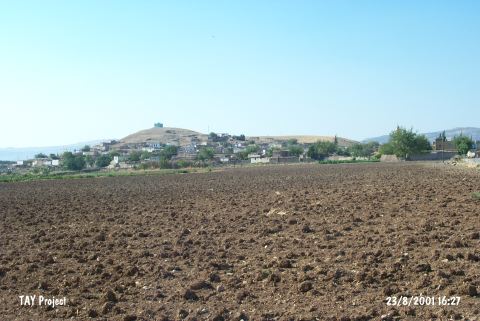 |
|
Type:
|
Mound |
|
Altitude:
|
848 m |
|
Region:
|
Southeastern Anatolia |
|
Province:
|
Kilis |
|
District:
|
Merkez |
|
Village:
|
Oylum |
|
Investigation Method:
|
Excavation |
|
Period:
|
New Assyrian Empire Period |
|
|
|
 |
|
| Location: The site lies 7 km south-southeast of Kilis; south of Gaziantep highway; right next to the village of Oylum. Southern slope; skirts and a part of the southeastern slope of the mound is occupied by the modern village and there are large sections due to the exercise of taking away soil on its eastern and western slopes and skirts [Özgen 1987:241; Özgen et al. 1997:42]. |
| Geography and Environment: The site lies at the intersection point of Euphrates Valley and Amuq Plain in East-West axis and of Northern Syria and Anatolian Plateau in North-South axis. The region has a central value because of the mild climate of Kilis Plain in the prehistoric era and of its geopolitical position in the Bronze Ages. West of the mound is the recently dried Akpinar Stream which has a low water level in seasons of heavy rain. The 460x320 m mound consists of two cones: the 22 m high northern mound and the 37 m high southern mound with a defile connecting the two. |
| History: |
| Research and Excavation: The excavation history of the region started in early 1900s. J. Garstang and B. Hrozny, M.V. Seton-Willams and P. van der Meer, and C. Hillen in the 1950s are among the scientists who conducted surveys and excavations in the region between Gaziantep and Halep. The importance of Oylum Höyük was first emphasized during the surveys conducted by U.B. Alkim in the Islahiye Plain, which were followed by an Italian team who conducted surveys in Gaziantep.The excavation project was launched as a joined effort of Gaziantep Museum and Hacettepe University in 1987. From 1990 to 2012, E. Özgen led the project on behalf of the Hacettepe University and German Archaeological Institute in Istanbul as partners. [Özgen 1987:241; 1990b:22; Özgen et al.1997:40-42]. The 2009 excavations are implemented by E. Özgen and team between 01.07.2009 and 31.08.2009 on the Northeast elevation of the mound. The main objective of researches going on in this settlement -which is a regional center during bronze ages- since 2007, is to investigate the mentioned periods on a large scale and to outline the stratigraphic structure. 8 individual 10 by 10 trenches are opened under the scope of landscape activities on the Northeast elevation of the mound. The work on Trenches J21, J22, K21, K22, and L22 that started during previous years have continued along with the new Trenches L21, M21, and M22 [Özgen et al. 2011: 56]. Since 2013, the excavations have been carried out by a team led by A. Engin. Oylum Höyük is listed as an officially registered archaeological site by the Ministry of Culture and Tourism. |
| Stratigraphy: The stratification studies showed an uninterrupted settlement from the Chalcolithic Age until the Hellenistic Period [Graves-Helwing 2001:480]. Five building levels were identified in trench W11b/X11a; these levels have a consistency and it seems that they belong to the 1st Millennium BC [Özgen et al. 1997:188-189]. |
| Small Finds: Architecture: The trench T15 yielded a wall constructed with basalt blocks, which were filled in with smaller stones in southwest-northeast direction using a different technique under the Hellenistic building which has been partly preserved. The floor of the wall was not found. Among the deposit were sherds and small finds which contributed to date the building to the 1st Millennium BC. It is located near the Syrian border, and a large-scale Iron Age building built with white and brown bricks was uncovered during the excavations. The trench L26 yielded a rectangular Iron Age kiln with no slag or ceramic finds. Excavations performed in the north half of square plan L26 on Western Elevation in 2004 yielded finds suggesting Red Wall Monumental Structure was dating to 2004 [Özgen et al. 2006:368]. A poorly preserved adobe wall lying northeast-southwest in the middle of the trench and a hearth on a square clay platform over the rammed earth floor were observed in building level 4 at plan J 22b in 2007 [Özgen et al. 2009:143]. Remains of a stone foundation of a northwest structure, and the remains of a large kiln were found in the first of 5 structure levels were found at plan J 22a. The second of the five structure levels at plan J 22a is represented by an adobe wall lying northeast-southwest, a semi-circular stone platform south of the wall and a round clay hearth north of the wall [Özgen et al. 2009:143-144]. The Structure Phase 3 of trench K22 during 2008 excavations was represented by many Iron Age round pits, and an in situ kiln which was partially inside the east profile of the trench and an in situ hearth formed by clay. The white lime plaster inside the pits that are approximately 1.5-2 m in diameter suggest that those were used for cereal storage. It is assumed that the east-west extending rectangular planned kiln had a vaulted cover. The north and east section of a large adobe structure that lies in northeast-southwest direction was unearthed inside the 4th Structure Phase which was dated to Iron Age. Round cereal silos plastered with white lime some of which measuring 3.5 m in diameter that were dated to Early Iron Age were unearthed in Structure Phase 5. The pits of larger silos are round planned and were inlayed using a single course of thin adobe. The silo walls and bottoms were plastered by a thick lime and straw tempered mortar [Özgen-Engin 2010:2-4]. A multi-room structure remains that lie northeast-southwest inside Structure Phase 4 of trench K21 and the northeast corner of a building inside structure phase 4 of trench K22 were revealed and it was found that there was a very narrow corridor between the two buildings. Stone foundations were not used on the adobe walls of the multi-room building inside the trench. Light red, greenish gray and lime tempered white square and rectangular adobe bricks were used on the building [Özgen-Engin 2010:5-6]. A stone paved floor covering and a hearth formed by placing the lower body underground dating to Iron Age were unearthed inside trench J22 [Özgen-Engin 2010:6-7]. An adobe structure that contained four rooms was unearthed at trench L22. The structure lies approximately in north-south direction [Özgen-Engin 2010:11]. Three structure levels dated to Iron Age were identified immediately north of the Roman Period solid red adobe wall inside trench J21b. Stone foundation remains and two adobe walls related to those phases were revealed in 2008 [Özgen-Engin 2010:12]. 2009 activities started on the East half of J21 Trench (J21b), and then the working field have extended to 10 by 10 m with the addition of J21a which is on the West slope. Red massive wall excavated in 2008 and the walls of two different structure phases from Iron Age are removed. It is understood that a large pit from Iron Age is filled with large rocks and adobe plaster to enforce the foundation of the red massive wall. The Structure Phase 3 is represented with rock-founded adobe walls preserved in the Southern half of the adobe walls that belong to the same building. A single row of rocks is used in the foundation of the wall. Remains of a rectangular oven are unearthed in the Southwest section of the trench. The adobe wall that is on the Northeast side of the trench belongs to the Structure Phase 4 and it is constructed in Northwest-Southeast direction of which one row of rocks is preserved. Structure Phase 5 is represented by four round pits just below Structure Phases 3 and 4. These pits have an ashy soil formation and their diameters are between 1.5 and 2 m. The age of Building Structure 6 excavated is determined as Early Iron Age. Remains of stone founded adobe walls constructed in Northeast-Southwest direction of this building period are unearthed. Single row of rocks are used in the foundation, and the adobe walls which are found on some foundations are preserved as one row. The walls have marks of destruction [Özgen et al. 2011: 57]. In the scope of 2009 activities in K21 trench, the pits used to support Roman Period red adobe massive wall and filled with adobe paste and the remains of Iron Age buildings which were initially excavated in 2008, are removed. The 5th structure phase which is unearthed later is from Iron Age. A building with at least four rooms in this structure phase in Northwest-Southeast direction. 6th building structure is represented by a small adobe building 3 by 2 constructed in Northwest-Southeast direction with pressurized soil base. This is believed to be a granary building for storing grains [Özgen et al. 2011: 59]. During 2009 researches with the K22 trench a new one is added to the Early Iron Age granary pits excavated earlier. A thin row of adobe bricks is laid around this granary pit which is 3m in diameter [Özgen et al. 2011: 60]. The excavations in L22 Trench started with the activities in the 4th structure phase which is partially unearthed in 2008. Remains of an adobe building without stone foundation exist in this structure phase which is aged as Iron Age. In the West of this building a street exits. The adobe building is partly destructed by round pits from the 3rd structure phase. The marks of white lime plaster in the base of the pits show that these were used as granaries. Animal bones and pieces of pottery captured in these pits which have an ashy soil formation show that these pits were used for trash dumping during the late phases. Remains of an adobe building with a rectangular plan almost in the East-West direction are detected in the 5th structure phase. The walls of the building are constructed without a stone foundation with one row of adobe bricks. 6th structure phase is also aged as Iron Age. In this building layer stones of wall foundations are observed some of which are irregularly laid. It is partially destructed. Looking at the parts preserved it is seen that this is a multiple room building. The most important finding in this phase is a 2 by 2.5 m small adobe building. This is a granary. A second pit right in the West of the granary is used as trash dump during the last phase. Partially preserved stone foundations of a building with two rooms are unearthed in the 7th structure phase which is aged as Early Iron Age. Large basaltic stones are used on the walls along with small stones [Özgen et al. 2011: 61-62]. Parts of a stone wall which does not have a plan are unearthed in Trench M22 which opened in 2009 in the South half of the trench about 0.5 m deep in the Building Layer 1. Adobe walls and stone foundations are unearthed in the Structure Phase 3 which is aged as Iron Age constructed almost in East-West and Northwest-Southeast direction. However no connection can be seen between the walls due to heavy destruction. Remains of a building constructed in Northwest-Southeast direction are encountered in the Structure Phase 4. This building belongs to Iron Age but it is destructed by the walls of Structure Phase 3 and by the pits of Structure Phase 2. Stone foundations are used in some parts of the walls. The age of Structure Phase 5 is also determined as Iron Age. Remains of a stone-founded adobe building constructed in Northeast-Southwest direction are detected in the Northeast corner of the trench. The stone foundations of the unearthed wall are as thick as 1.5 m. Medium sized stones are placed in the outer faces of stone foundation and small debris stones and adobe are used in the middle [Özgen et al. 2011: 62-63]. In 2010, in Trench L21 a stone wall extending in the north-south direction, an oven located on the compressed earth floor and a base sherd belonging to a pithos placed beneath the floor represent the building level 4 which is dated to Late IA. The stone foundations belonging to two walls extending on the north-south direction in middle of the trench indicate a new building level. This new building level (building level 5) dated to Middle IA has been heavily damaged by the large pits belonging to Late IA. After discovering the remains of the occupation level dated to Early IA, the studies conducted in this trench have been finished. The remains of stone foundation belonging to building level 5 were found on the northern half of the trench. On the southern half the trench, the remains of mudbrick wall belonging to Early IA and two clay crescent-shaped hearths were discovered [Özgen et al. 2012:506]. The studies in Trench M22 were continued on Early IA Level which was exposed in 2009. In this building level, the foundation stones belonging to a wall with a width of 1.5 m which comes off on the northeast corner of the trench and extends in the northeast-southwest direction and stone foundations damaged by the pits belonging to upper levels have been encountered [Özgen et al. 2012:509]. During the 2011 studies, it is seen that Early IA level in Trench L21 has been heavily destructed by the pits belonging to the late level of IA. In the pits with a diameter of 1.5-2.5 m, traces of white lime plaster were encountered. These traces indicate that these pits might have been used as silo. The floors of two pits were covered with stones. In Early IA level, architectural remains are preserved on the northern half of the trench. This level is represented by two mudbrick siloi. These rectangular planned siloi extend in the east-west direction. The silo belonging to Early IA exposed on the northeast corner of the trench measures about 3.5x3 m and it is square like rectangular planned. It was built into the pit dug into the floor and lower rows of its mudbrick walls are preserved. The thick white lime plaster on the floor and interior surface of the walls is partially preserved. While this silo was completely built with square shaped mudbricks, the second one on its northwest was erected on stone foundation. The north wall of second silo extends into the north profile wall of the trench. This silo has white lime plastered floor as well. The thick plaster is chaff and lime tempered. During the studies carried out in 2011, it is discovered that the water channel located on the southwest section of the trench is dated to LBA. The studies conducted in Trench L21 yielded a cylinder stamp made out of red stone, shell beads, clay anthropomorphic and zoomorphic figurine pieces, bronze pin with knob, an iron arrowhead, basalt grinding stones and a bulla with Luwian hieroglyphics. A conical bulla with Luwian hieroglyphics found in the mixed burnt soil in the area on the north the mudbrick wall is the most important finding recovered from the level [Özgen et al. 2013:325-326]. In 2012, the studies were conducted in the trenches of L21, K21, K22, J21, J22 (opened in previous years) and I21, K23, L23, M23 (recently opened). In Trench M23, remains of stone foundation wall, fragments of storage jars sit on the floor and round siloi belonging to the Late IA were exposed. Below this level, remains of Late IA that were relatively well preserved were reached. In this area, a small women statuette made out of basalt was found as well. In Trench L23, 4 round siloi, a 3 m wide street extending in the northwest-southeast direction and remains of two buildings belonging to the Late IA were exposed. The buildings were built with mud brick on stone foundation. Remains of a structure, the continuation of which was found in Trench L23, were unearthed in Trench K23. The structure was erected with mud brick on stone foundation and partially damaged by the pits belonging to the Hellenistic Period. The structure has two phases. In front of the northern profile of the trench, a hearth with the appearance of a clay platform was exposed. The hearth extending in the northwest-southeast direction measures about 1x2 m. It was observed that the occupation layer of Early IA in Trench L21 has severely damaged the Late IA level. In this area, the cultural deposit of Late IA yielded a clay tablet bearing Hittite inscription. This tablet was regarded as a letter of agreement between two parties or an order that was sent to a local government by the Great King of the Hittites. In Trench I21 located in the western slope of the mound, architectural remains of Late IA were exposed just below the surface. These architectural remains consist of a partially preserved stone foundation wall and 2 pits. The pits, the diameters of which are 1 m and 1.5 m, contains ash in high density. They were initially used as silo and then they functioned as ash pits [Özgen et al. 2014]. In 2013, the walls of stone foundation belonging to Late IA exposed in the trenches of K23, L23 and M23 were removed. Under these remains, smaller stone foundations and mudbrick walls that have been damaged by the upper level were exposed. In this building level, the houses are located in the east and west of the street unearthed in Trench L23. The street with a width of about 3 m is bordered with the walls of two structures in the east and west. Remains of stone foundation and mudbrick wall exposed on both sides of the street indicate the existence of rectangular planned buildings. At the southeast corner of Trench M23, remains of a hearth related to the structure in this area were exposed. Middle IA building level consisting multi-roomed houses was unearthed below Late IA building level in Trench L23. These remains are located on the same street. During three building phases, the same street continued to be used. Partially preserved mudbrick remains were found in Trench K23. These remains indicate the existence of a mudbrick terrace in the west of the structure. The stone foundation wall bordering the east of the street was reinforced by a short wall built with small stones in the east. The structures consist of multi-roomed small rooms. The buildings in Trench M23 have been severely damaged by stone foundations and a great number of pits belonging to the upper phase. In all trenches, a lot of pits dated to the early phase of Middle IA were exposed. This situation indicates that this area located in the northwest section of the mound was used for storage pits. The Early IA building level yielded remains of stone foundation and mudbrick wall. These remains reflect a layout of multi-roomed houses extending in the northwest-southeast direction [Engin et al. 2015:236-238]. During the 2014 studies, three large structures were exposed in Trench K23 and L23. These buildings were built with square and rectangular mud bricks. In Trench L23/ÖZA Space 138, a hearth that is plastered with clay was found on the compressed soil floor. The floor of this hearth was covered with pottery sherds. The ground stones found in this space indicate that it might be used as a kitchen [Engin et al. 2016:446-448]. During the 2014 studies, three large structures were exposed in Trench K23 and L23. These buildings were built with square and rectangular mud bricks. In Trench L23/ÖZA Space 138, a hearth that is plastered with clay was found on the compressed soil floor. The floor of this hearth was covered with pottery sherds. The ground stones found in this space indicate that it might be used as a kitchen [Engin et al. 2016:446-448]. LBA level were reached in trenches K23, L23 and M23. This level distinguishes from the upper level with red-colored burnt soil. During the studies conducted in Trench M23, remains belonging to a thick-walled structure with a width of about 1 m were exposed. This structure was built with mud brick on a stone foundation. The golden applique found on the floor level of the courtyard in Trench L23 is the most striking find of this season. The water channel in the section of LBA courtyard that remained in Trench L23 was built to drain water in the courtyard. The neatly cut square-shaped basalt slabs of the channel were probably used as spolia [Engin et al. 2016:446-448]. Pottery: The vessels that were dated to the Iron Age are wheelmade, and mostly in buff color. The finds such as sherds decorated with concentric circles, painted sherds, partly reconstructed amphora, two miniature vessels and a vase with a decorated rim, they all suggest that the pottery of Oylum Höyük pottery was parallel to the material uncovered in many East Mediterranean sites including Mersin and Tarsus in addition to those found in Cyprus, particularly in the levels belonging to the first half of the 1st Millennium BC [Özgen et al. 1997:188-189]. Various sherds were revealed in the 3rd of the 4 structure levels at plan J 22b in 2007, that were dated to Iron Age. The fourth level is represented by an irregular building level where large amounts of Middle Iron Age sherds were unearthed [Özgen et al. 2009:143]. The sherds found in the 3rd of 5 building levels at plan J 22a also belong to Iron Age [Özgen et al. 2009:143-144]. The pottery pieces captured in 2009 in Trench K21 in the Structure Phase 6 are from Early Iron Age [Özgen et al. 2011: 59]. The pottery pieces captured in Trench L22 in the Structure Phase 4, 5 and 6 are from Iron Age [Özgen et al. 2011: 61]. Intense amount of Late Iron Age pottery pieces are captured in Trench M22 in Structure Phase 1. Most of these are cord imprinted and decorated jar pieces. Also a big vessel made of basalt is captured in pieces [Özgen et al. 2011: 62]. In the 2012 campaign, one of the pits (I21b/ÖZA 9) in Trench I21 yielded amphora and cooking pot sherds and an almost complete jug [Özgen et al. 2014:165]. Bone: A bone spatula was found within the Iron Age context. Bone ceramic-burnishing tools were yielded inside trench K22 in 2008 [Özgen-Engin 2010:4]. Animal bones are captured in Trench L22 in Structure Phase 4 and 6 in 2009 [Özgen et al. 2011: 61-62]. Clay: Özgen reports that a terra cotta horse head and a figurine fragment as well as a human figurine were unearthed at trench W11b/X11, and based on their stylistic characteristics and ceramic data the finds were dated to the Iron Age [Özgen et al. 1997:188-189]. A terra cotta animal figurine dated to Iron Age was found in the 3rd of 4 building levels at plan J 22b in 2007 [Özgen et al. 2009:143]. In 2008 terra cotta spindle whorls, loom weights, one terra cotta toy wheel fragment and a bull figurine, all dated to Iron Age were yielded inside trench K22 [Özgen-Engin 2010:4]. Metal: A copper awl was revealed in the 3rd of 4 building levels at plan J 22b in 2007 [Özgen et al. 2009:143]. Iron Age iron and bronze awls and pins inside trench K22 [Özgen-Engin 2010:4], a bronze hair-spiral inside trench K21 [Özgen-Engin 2010:6], lead wire pieces and iron objects inside trench J22 [Özgen-Engin 2010:10], an iron drill point and its cutting parts were yielded inside trench L22 [Özgen-Engin 2010:11]. A bronze pin, a bronze earring, a fragment of shell bead, 7 beads made out of stone, faience and frit were recovered during the 2010 excavation campaign [Özgen et al. 2012:560]. Seal: A cylindrical seal recovered from trench R15 is noteworthy. It is made of limestone, and it depicts a scene with a linear style on the impression surface of the seal. A man figure was depicted throwing an arrow and wearing a long dress on the left side of the scene, which is familiar from the Neo-Assyrian seals [Özgen et al. 1997:188-189]. A semi-preserved enamel cylindrical seal was found in the 3rd of 4 building levels at plan J 22b in 2007 [Özgen et al. 2009:143]. In 2008 an Iron Age earthenware cylindrical seal fragment and a stone seal were yielded inside trench K22 [Özgen-Engin 2010:4], a diorite stone cylindrical seal and a terra cotta seal were yielded inside L22 [Özgen-Engin 2010:11]. During the 2014 studies, a conical bulla belonging to LBA was found [Engin et al. 2016:456]. |
| Remains: |
| Interpretation and Dating: |