| ©The Archaeological Settlements of Turkey - TAY Project | ||||||
|
|
||||||
Kanligeçit |
||||||
|
|
||||||
| Ages | Maps | Photos | ||||
| Chalcolithic EBA IA |
 |
 |
||||
|
|
||||||
|
Type:
|
Mound | |||||
|
Altitude:
|
138 m | |||||
|
Diameter:
|
m- Direction: | |||||
|
|
||||||
|
Region:
|
Marmara | |||||
|
Province:
|
Kirklareli | |||||
|
District:
|
Merkez | |||||
|
Village:
|
Merkez | |||||
|
|
||||||
|
Destruction :
|
Other - Agriculture | |||||
|
|
||||||
|
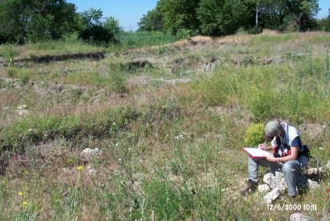
TAYEx:
|
Visited - 12/6/2000 | |||||
|
|
||||||
|
Registration State:
|
Registered For detailed registration information please refer to Turkish pages. | |||||
 |
||||||
| Location: It lies on both banks of the Haydar stream; 250 m east of the road running to the Asilbeyli Village from Kirklareli; about 500 m south of the Kirklareli Province. |
| Geography and Environment: The Kanligecit settlement has been partly destroyed by the Kirklareli railroad. It divides the settlement into two. When discovered in 1981; the settlement was evaluated separately in three parts; Kanligecit north (B5/17); Kanligecit south (B5/18) and Kanligecit east (B5/16). Kanligecit North is an acropolis of the EBA settlement. After the excavation; the walls in the trenches were supported with wooden beams; the trenches were covered with nylon for protection. |
| Destruction Details: The whole settlement is divided into four by Haydardere stream and the railroad. The eastern and southeastern sections of the excavation area is bordered with barb wire and being cultivated. It is known that this section is included in the settlement [TAYEx 12.6.2000]. |