| ©The Archaeological Settlements of Turkey - TAY Project | ||||||
|
|
||||||
Hacinebi |
||||||
|
|
||||||
| Ages | Maps | Photos | ||||
| Chalcolithic IA 14C |
 |
 |
||||
|
|
||||||
|
Type:
|
Mound | |||||
|
Altitude:
|
520 m | |||||
|
Diameter:
|
m- Direction: | |||||
|
|
||||||
|
Region:
|
Southeastern Anatolia | |||||
|
Province:
|
Sanliurfa | |||||
|
District:
|
Birecik | |||||
|
Village:
|
Ugurcuk | |||||
|
|
||||||
|
Destruction :
|
Agriculture - Contemporary Settlements | |||||
|
|
||||||
|
TAYEx:
|
Visited - 16/8/2001 | |||||
|
|
||||||
|
Registration State:
|
Registered For detailed registration information please refer to Turkish pages. | |||||
 |
||||||
| Location: The site lies northwest of Sanliurfa; 5 km north of Birecik District; near Ugurcuk (Hacinebi) Village. One can easily get to the mound via the village road going north from Birecik. |
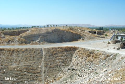
| Geography and Environment: The site is located where the Euphrates makes a meander towards north; on the trade route along the river from Mesopotamia to the inner sections of Anatolia; at the junction point of all the roads. The mound is at the first northern terrace of Euphrates; on top of a ridge looking towards the bed of Euphrates. The 240x140 m mound is roughly triangle in shape; 2 m high at the west; and 7 m high at the east. It is thought to be on a limestone elevation; and covers an area of approximately 3.3 hectares. The site is sheltered naturally except for the eastern section. It is reported that the mound will not be effected by Birecik Dam. |
| Destruction Details: There are houses and trenches on the eastern part of the mound and a grave known as belonging to Haci Nebi is on the western part. The top is being used for agricultural activities [TAYEx 16.8.2001]. |