|
©The Archaeological Settlements of Turkey - TAY Project
|
|
|
|
|
|
Hacinebi |
|
|
For site maps and drawings please click on the picture... 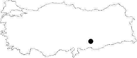 |
For photographs please click on the photo... 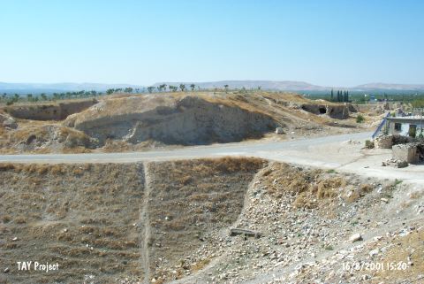 |
|
Type:
|
Mound |
|
Altitude:
|
520 m |
|
Region:
|
Southeastern Anatolia |
|
Province:
|
Sanliurfa |
|
District:
|
Birecik |
|
Village:
|
Ugurcuk |
|
Investigation Method:
|
Excavation |
|
Period:
|
Late |
|
|
|
 |
|
| Location: The site lies northwest of Sanliurfa; 5 km north of Birecik District; near Ugurcuk (Hacinebi) Village. One can easily get to the mound via the village road going north from Birecik. |
| Geography and Environment: The site is located where the Euphrates makes a meander towards north; on the trade route along the river from Mesopotamia to the inner sections of Anatolia; at the junction point of all the roads. The mound is at the first northern terrace of Euphrates; on top of a ridge looking towards the bed of Euphrates. The 240x140 m mound is roughly triangle in shape; 2 m high at the west; and 7 m high at the east. It is thought to be on a limestone elevation; and covers an area of approximately 3.3 hectares. The site is sheltered naturally except for the eastern section. It is reported that the mound will not be effected by Birecik Dam. |
| History: |
| Research and Excavation: The site was discovered during the survey for documenting the sites that are to be inundated by the dams on Euphrates and Tigris; conducted by G. Algaze. Many Uruk sherds were recovered from the surface; and a very thick mud-brick fortification wall was encountered. The mound was excavated in 1992-1997 by the Northwestern University and the Sanliurfa Museum under the directorship of G. Stein in the name of the same university. Trenches; in various dimensions; were opened without dividing the mound into grids. 1400 square meters are reported to be excavated at the end of 1996. Two seasons of artifact analysis work done at the Sanliurfa Provincial Museum (1998-1999). It takes place in the registered archaeological sites list prepared by Ministry of Culture and Tourism. |
| Stratigraphy: The stratigraphy of the mound (also including 1996 excavation) is: Roman Period farm west of the mound (1st century AD) Acheamenid / Hellenisitic Level (500 Ğ 100 BC) Early Bronze Age Graves (3100 Ğ 2700 BC) Late Chalcolithic Age B 2 / Uruk Period (3700 Ğ 3200 BC) Late Chalcolithic Age B 1 / Late Pre-Uruk Period (3800 Ğ 3700 BC) Late Chalcolithic Age A / Early Pre-Uruk Period (4000 Ğ 3800 BC) [Stein et al. 1997:112; Stein et al 1998:145]. Settlements were revealed only from the three main periods; Acheamenid / Hellenistic; EBA I graves and Late Chalcolithic Age. The thickness of first level varies in 1-2.5 m. There are 3 building levels. Below this is the Late Chalcolithic Age level at niveau 5 m; consisting of two main building levels and slightly cut by the upper level and the graves. This level is divided into phases according to the Uruk Period pottery. The virgin soil was reached. |
| Small Finds: Architecture: Phase A: This phase is being represented by three building levels at the northeast part of the mound (Area A). Only one hearth and some mud brick remains found at the earliest building level; below virgin soil. It is understood that the South Building at the third building level was first constructed in the second building level. The remains of this building thought to be the storage (with a pebble pavement floor and a drainage system) of the two-storied building in the second building level. There is a building complex with three sections in the third building level. South Building of this complex has stone foundation and two rooms. The interior; exterior walls and the floor of the building are plastered. A niche; a circular hearth and square sectioned mud brick columns which used as doorjambs were found in the building that was underwent a fire. Middle Building with stone foundation consists of three areas and one of them may be a courtyard. There are big storage jars; a hearth and in situ finds related with mining in this building and two of the doors open through west courtyard. North Building should be a two-storied house with mud brick walls and has no stone foundation. All of these buildings have had important revisions for several times. These buildings locating west of the big stone platform are eastern border of the settlement in this period [Stein et al. 1998:146-148]. There is an enclosing wall south of the mound (Area B) constructed in late building levels of Phase A and it forms the southern border of the settlement. At the former phases of this wall; a small settlement exists in this area; which is represented by simple rectangular mud brick houses and streets (?). The compressed soil floors are white plastered. Sun-dried mud bricks with no foundation pit have built up the enclosing wall. There are niches and braces on its interior face and a pise platform on exterior face measuring 9x5 m in dimension supported by wooden beams. At the following phase a platform built inside of the wall after leaving a corridor in north-south direction. This wide platform is 3 m high and it has been built up by sun-dried mud bricks at the lower part; under the rough limestone courses. The copper melting pits and negative architectural traces suggest that the area outside the wall has been used as a work place. It is understood that there was a settlement outside of the wall at the upper phase [Stein et al. 1998:148-152]. Plastered hearths and abreast rectangular silos which were encircled by stone were found on bedrock west of the mound (Area C). The architectural remains yielded from the upper phase are houses with 3 or 4 room; thin mud brick walls; ash and garbage pits; hearths and cylindrical drainage pipes. The top building level of Phase A at this area is represented by the buildings named as Stone Storage Room. These buildings are related with each other but one of them differs from others with its mud brick walls and little courtyard with pebble pavement. The other two have stone exterior walls and mud brick partition walls. It is thought that these two-roomed narrow buildings have been used as storages or for mining activities [Stein et al. 1998:152-154]. Phase B 1: This phase is represented by a platform; terrace buildings and an ashy embankment at the area north and east of the platform. The platform at the later phases of Phase A has been enlarged at this phase. Ruined buildings show that the settlement extends beyond the enclosure wall. The continuity between Phase A and B 1 is also observed in Area C. Parallel ranged narrow houses with stone foundation obtained at the accumulations in this area. There are intramural children burials in these houses; which all face a courtyard with stone pavement. Phase B 1 is being represented with these repeating houses at this area [Stein et al. 1998:146-147;149-150; 152]. Phase B 2: This phase has been destructed and cut by EBA burials in Areas B-C. The house with the braces has been heavily destructed [Stein et al. 1997:fig. 5]. Pottery: Both Uruk ware groups and the Late Chalcolithic Age ware of Southeastern Anatolia are recovered stratified among the Late Chalcolithic Age Phase B ceramics. Southern Mesopotamia Late Uruk Period characteristics are observed on the wheel-made; sand-tempered ware [Stein et al. 1997:132]. On the contrary; straw or plant-tempered; hand-made vessels are observed at the Late Chalcolithic Age cultures. Only Late Chalcolithic Age wares are existent at the Early Pre-Uruk Period of Hacinebi (Phases A and B 1). Uruk wares were also added to this group beginning from Phase B 2. The techniques of Pre-Uruk Period settlers of Hacinebi were comprehended by the technological analyses of Hacinebi pottery. It is understood that wheel has been used for making little pots beginning from Phase A as well as piece building and coil techniques. Wheel made forms increase in Phase B 1. It is reported that the wheel used in these two periods is not aimed at mass production. Local pottery is being represented by bowl types like hammerhead; crested or folded out rim; pot types like banded rim; necked or without neck forms and squat crested cooking pots. All types of Uruk pottery have been observed in the period contemporaneous with the Uruk Period. Beveled rim bowls; conical bowls that the bottoms made by string-cut; spouted pots and vessel forms are typical for this period. The traces of plaster on some pots hinted that they have been buried into the earth. Several Obaid type sherds are found. Phase A is researched by K. Boden; and Phase B is by J. Pearce [Stein et al. 1998:160-166]. Clay: Glyptic decorations of this period are observed on the Uruk Period "bullae". Spindle-whorls and finds related with mining like baked clay bellows; curicibles and moulds are also found. The cylindrical baked clay tiles are among the interesting finds. Chipped Stone: The industry is studied by C. Edens. Transparent; opaque and banded cream-colored flints are commonly used; but the obsidian is rare and it has been preferred only for making bifacial triangle points. Chipped stone industry shows three different technologies as flake industry; Kenanian blade industry and simple blade industry. It is observed that types like backed; serrated and retouched blades; perforators; scrapers and sickle-knives are existent. Cores with single and multi striking platforms; disc or discoid shaped cores and even Levalloisien cores were recovered. There are tiny differences between phases but this technology is permanent. Silica sheen and traces of use have been seen on the tools [Stein et al. 1998:155-159]. Ground Stone: Very beautiful eye idols made of limestone were recovered from the surface and trenches [Stein et al. 1997:fig.4 / 1-4]. Three seals from Phase A are made of limestone; they are flat rectangular in shape and have motifs made by simple scratches. There is a stylized human depiction on one of them; a shaman holding an axe and a bird; a mixed creature stand nears him. Seals were studied by H. Pittman [Stein et al. 1998:171-172]. There is also basalt grinding stones have been yielded. Bone/Antler: A stamp seal yielded from Phase B 2. It has a shape of a lying lion and there are simple scratches on it [Stein et al. 1998:172]. Metal: Metal finds of Hacinebi suggest that the settlers were advanced in metal technology. H. Özbal observed all of the metal finds in detail; and reports that the natural ores with sulphide were smelted and also casting was being done [Stein et al. 1997:139 Ğ 141]. The wide plastered pits with slag; moulds and baked clay bellows outside of the enclosing wall are the proofs of mining activities. No alloy was made but copper ore with high arsenic ratio was used. Copper burins; pins and chisel types are also existent [Stein et al. 1998:167-170]. Human Remains: There is a cist grave at the inner part of the enclosing wall in Area B; in a pit of 1.6 m deep and surrounded by stone. This straight lying burial belongs to an adult. No grave goods have been yielded from the grave that is not completely opened yet [Stein et al. 1998:149]. Under floor children burials belonging to Phase B 1 found in Area C. Flora: No information is given about the finds but is reported that botanical investigations are being done [Stein et al. 1998:154]. |
| Remains: |
| Interpretation and Dating: General characteristics of the Late Chalcolithic Age settlement of Hacinebi have been recorded during the excavations conducted by Stein since 1992. One of the main aims of the excavations is to find out the changes in the local culture before the Uruk Period. Hacinebi is one of the excavations with this aim as Tell Brak and Arslantepe. Pre-Uruk Period researches showed that Hacinebi was a settlement with a complex social organization in this period; basing on the advanced metal technology; the existence of far distance raw material trade; the monumental buildings and separating the areas for different activities. The figures on seals which resembling the ones in Tell Brak; Çoga Mis and Luristan are interpreted as the sign of a common elite ideology [Stein et al. 1998:144; 171-173]. The metal resources are thought to be the same ones used in Arslantepe; Norsuntepe; Degirmentepe; Tepecik and Tülintepe [Stein et al. 1998:168]. Structural remains that are being revealed one by one for now hint the existence of such big structures in the Uruk Colonization Period. Hacinebi has an important function by displaying concrete relations between Anatolia and Mesopotamia. The uncalibrated 14C dates from Level A are between 4170 Ğ 3986 BC and 3793 Ğ 3497 BC; and those from Level B are between 3604 Ğ 3510 BC; 3826 Ğ 3638 BC. The site; considering all the finds; dates to the end of Late Chalcolithic Age. The finds are being exhibited in Sanliurfa Museum. |