|
©The Archaeological Settlements of Turkey - TAY Project
|
|
|
|
|
|
Hacinebi |
|
|
For site maps and drawings please click on the picture...  |
For photographs please click on the photo... 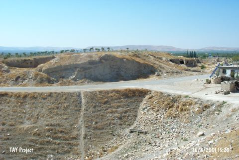 |
|
Type:
|
Mound |
|
Altitude:
|
520 m |
|
Region:
|
Southeastern Anatolia |
|
Province:
|
Sanliurfa |
|
District:
|
Birecik |
|
Village:
|
Ugurcuk |
|
Investigation Method:
|
Excavation |
|
Period:
|
Post Assyrian Period |
|
|
|
 |
|
| Remains from the Achamenid and Hellenistic Periods (5th and 2nd centuries BC) were identified in three excavation areas of the mound during four campaigns. The building levels can be divided into three phases. The earliest one is a simple domestic structure characterized by massive mudbrick and stone, with findings such as belongings of the householders, several terra cotta Persian cavalries and female goddesses [Gates 1997:250]. It takes place in the registered archaeological sites list prepared by Ministry of Culture and Tourism. |
| Location: The site lies northwest of Sanliurfa; 5 km north of Birecik District; near Ugurcuk (Hacinebi) Village. One can easily get to the mound via the village road going north from Birecik. |
| Geography and Environment: The site is located where the Euphrates makes a meander towards north; on the trade route along the river from Mesopotamia to the inner sections of Anatolia; at the junction point of all the roads. The mound is at the first northern terrace of Euphrates; on top of a ridge looking towards the bed of Euphrates. The 240x140 m mound is roughly triangle in shape; 2 m high at the west; and 7 m high at the east. It is thought to be on a limestone elevation; and covers an area of approximately 3.3 hectares. The site is sheltered naturally except for the eastern section. It is reported that the mound will not be effected by Birecik Dam. |
| History: |
| Research and Excavation: |
| Stratigraphy: |
| Small Finds: |
| Remains: |
| Interpretation and Dating: |