| ©The Archaeological Settlements of Turkey - TAY Project | ||||||
|
|
||||||
Girnavaz |
||||||
|
|
||||||
| Ages | Maps | Photos | ||||
| Chalcolithic EBA IA |
 |
 |
||||
|
|
||||||
|
Type:
|
Mound | |||||
|
Altitude:
|
450 m | |||||
|
Diameter:
|
m- Direction: | |||||
|
|
||||||
|
Region:
|
Southeastern Anatolia | |||||
|
Province:
|
Mardin | |||||
|
District:
|
Nusaybin | |||||
|
Village:
|
Girnavaz | |||||
|
|
||||||
|
Destruction :
|
Contemporary Settlements | |||||
|
|
||||||
|
TAYEx:
|
Visited - 20/9/2001 | |||||
|
|
||||||
|
Registration State:
|
Registered For detailed registration information please refer to Turkish pages. | |||||
 |
||||||
| Location: It lies 5 km far from the border of Syria; 4 km north of the Nusaybin District; southeast of the Mardin Province. |
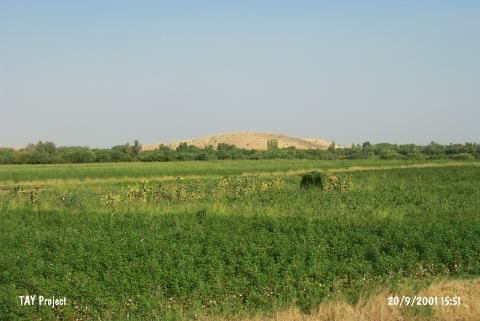
| Geography and Environment: The Çag Çag river cleaving a canyon through a hill known as Tur Abdin or Mardin Esigi [Erkanal-Erkanal 1989:131] flows to the south; to Northern Mesopotamia by leaving a rocky land like a peninsula in the southern end of this canyon. On this rocky land stands a round hill called Girnavaz. It measures 24-25 m in height and 350 m in diameter [Erkanal 1984:131]. Even tough there is a very low terrace on the south; the northern terrace forms a lowland. At present; the mound is surrounded by fertile gardens. The region has a humid climate. The canyon cleft by the Çag Çag River (Harmis) is the beginning of a natural road reaching to Batman over the Savur River. Erkanal identify Girnavaz as the gate of the valley since it is located right at the entry of the Çag Suyu Valley [Erkanal 1998:173]. |
| Destruction Details: The site of Girnavaz is destructed by the place where a holy man is buried and by the path goes up [TAYEx 20.9.2001]. |