|
©The Archaeological Settlements of Turkey - TAY Project
|
|
|
|
|
|
Girnavaz |
|
|
For site maps and drawings please click on the picture...  |
For photographs please click on the photo... 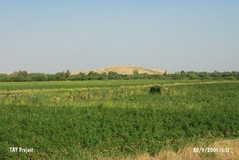 |
|
Type:
|
Mound |
|
Altitude:
|
450 m |
|
Region:
|
Southeastern Anatolia |
|
Province:
|
Mardin |
|
District:
|
Nusaybin |
|
Village:
|
Girnavaz |
|
Investigation Method:
|
Excavation |
|
Period:
|
Late |
|
|
|
 |
|
| Location: It lies 5 km far from the border of Syria; 4 km north of the Nusaybin District; southeast of the Mardin Province. |
| Geography and Environment: The Çag Çag river cleaving a canyon through a hill known as Tur Abdin or Mardin Esigi [Erkanal-Erkanal 1989:131] flows to the south; to Northern Mesopotamia by leaving a rocky land like a peninsula in the southern end of this canyon. On this rocky land stands a round hill called Girnavaz. It measures 24-25 m in height and 350 m in diameter [Erkanal 1984:131]. Even tough there is a very low terrace on the south; the northern terrace forms a lowland. At present; the mound is surrounded by fertile gardens. The region has a humid climate. The canyon cleft by the Çag Çag River (Harmis) is the beginning of a natural road reaching to Batman over the Savur River. Erkanal identify Girnavaz as the gate of the valley since it is located right at the entry of the Çag Suyu Valley [Erkanal 1998:173]. |
| History: |
| Research and Excavation: It was introduced by A.T. Olmstead. It attracted the attention both because of its size and being on the road running from Northern Mesopotamia [Erkanal 1985:121]. It became necessary to excavate when 22 pieces belonging to a cemetery of the third millennium BC were brought to the Museum of Mardin in 1981 [Erkanal (A) 1984:71]. The surface collection conducted in 1980 was followed by excavations from 1982; except 1985; to 1991 the year the excavation team was attacked by the terrorists. The name of Nabula written in one of the tablets recovered during the excavation led to conclude it as a settlement of New Assyrian Period [Erkanal 1986:207]. Likewise; due to the resemblance of its name; the city of Nawala referred in the inscriptions of the second millennium BC is suggested to be settled here. The name of the third millennium BC settlement on the top hill housing some architectural remains and a cemetery is unknown. It takes place in the registered archaeological sites list prepared by Ministry of Culture and Tourism. |
| Stratigraphy: According to the surface finds; settlements date from the Uruk culture of Northern Mesopotamia to the New Assur Period. The latest period revealed during the excavations is the Medieval Age on top of the mound; and is represented with a cemetery. New Assur levels; partly damaged by the graves; are below these graves. 2nd Millennium BC levels were revealed during the soundings at the northern terrace of the mound. Uruk Period levels were found beneath the EBA levels at the northeastern terrace excavation |
| Small Finds: Pottery: Red and black-gray Uruk sherds were recovered from a small; depth sounding at the northeastern terrace of the mound [Erkanal-Erkanal 1989:132]. |
| Remains: |
| Interpretation and Dating: There is no detailed information especially about the Chalcolithic Age finds. |