|
©The Archaeological Settlements of Turkey - TAY Project
|
|
|
|
|
|
Girnavaz |
|
|
For site maps and drawings please click on the picture...  |
For photographs please click on the photo... 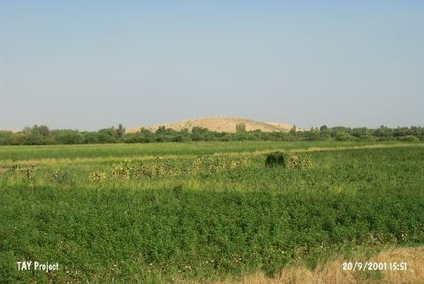 |
|
Type:
|
Mound |
|
Altitude:
|
450 m |
|
Region:
|
Southeastern Anatolia |
|
Province:
|
Mardin |
|
District:
|
Nusaybin |
|
Village:
|
Girnavaz |
|
Investigation Method:
|
Excavation |
|
Period:
|
EBA III EBA II |
|
|
|
 |
|
| Location: It lies 5 km far from the border of Syria; 4 km north of the Nusaybin District; southeast of the Mardin Province. |
| Geography and Environment: The Çag Çag river cleaving a canyon through a hill known as Tur Abdin or Mardin Esigi [Erkanal-Erkanal 1989:131] flows to the south; to Northern Mesopotamia by leaving a rocky land like a peninsula in the southern end of this canyon. On this rocky land stands a round hill called Girnavaz. It measures 24-25 m in height and 350 m in diameter [Erkanal 1984:131]. Even tough there is a very low terrace on the south; the northern terrace forms a lowland. At present; the mound is surrounded by fertile gardens. The region has a humid climate. The canyon cleft by the Çag Çag River (Harmis) is the beginning of a natural road reaching to Batman over the Savur River. Erkanal identify Girnavaz as the gate of the valley since it is located right at the entry of the Çag Suyu Valley [Erkanal 1998:173]. |
| History: |
| Research and Excavation: It was introduced by A.T. Olmstead. It attracted the attention both because of its size and being on the road running from Northern Mesopotamia [Erkanal 1985:121]. It became necessary to excavate when 22 pieces belonging to a cemetery of the third millennium BC were brought to the Museum of Mardin in 1981 [Erkanal (A) 1984:71]. The surface collection conducted in 1980 was followed by excavations from 1982; except 1985; to 1991 the year the excavation team was attacked by the terrorists. The name of Nabula written in one of the tablets recovered during the excavation led to conclude it as a settlement of New Assyrian Period [Erkanal 1986:207]. Likewise; due to the resemblance of its name; the city of Nawala referred in the inscriptions of the second millennium BC is suggested to be settled here. The name of the third millennium BC settlement on the top hill housing some architectural remains and a cemetery is unknown. It takes place in the registered archaeological sites list prepared by Ministry of Culture and Tourism. |
| Stratigraphy: The exact stratification was not identified as the excavation was carried out on the top hill; northern; eastern and northeastern slopes independently. This results from the fact the excavation were discontinued. The surface finds expose that the site had been inhabited from the Late Chalcolithic Age (Uruk) to the Middle Age. The hill was employed as a cemetery of the Early Islamic Period during the last period. The cemetery destroyed the architecture of the New Assyrian Period. The top hill houses a first millennium BC settlement; eastern and northeastern slopes a second millennium BC settlement while the northeastern and northern slopes house a third millennium BC settlement. The prehistoric layers and the cemetery were identified during the excavation on the northeastern slope. 9 layers identified are dated as follows [Akyurt et al. 1993:274]; Layers 1-2: Beginning of the Second Millennium BC Layers 3-5: End of the Third Millennium BC (EBA III) Layers 6-9: Early Dynasty I-III Period (EBA II) |
| Small Finds: Architecture: The northeastern trench yielded mass groups of stones at layer III. Only a square-planned room was uncovered. It has 1-1.5 m thick stone walls. A great blockage of clay is interesting at layer IV. Layer VI yielded a foundation wall built by big quarry stones in the east-west direction. A kiln and an oven were recovered. Fragments of two-row foundations were found at layer VIII while of mudbrick walls at layer IX. As the excavated area is a slope and excavation was conducted in smaller areas; only scanty architectural remains were reached [Akyurt et al. 1993:270-274]. Therefore; the settlement plan of Girnavaz is unclear. Pottery: The Khabur ware collected from the upper level of layer III in the same trench decreases in number through the lower layers. This layer yielded sherds of the Nineveh V ware; cited by this name in the archaeological literature as it was first recovered from the layer V of Nineveh; as well as the black-gray washed; burnished ware groups. The layer IV houses vessels of Nineveh V; again; and samples of the metallic ware. From layer V; undecorated Nineveh V sherds are accompanied with incised decorated samples. Samples of the metallic ware continue at layer VI [Akyurt et al. 1993:273]. Ground Stone: The small finds recovered from Girnavaz are not defined in detail. Grinding stone was found. Human Remains: Intramural Cemetery: The 1991 excavation yielded a male skeleton buried with his axe and dagger at layer III and a female skeleton accompanied with a string of beads; two maces headed bronze pins and a bronze ring at layer VI. Those finds evidenced; athough rare; the presence of intramural burials. Extramural Cemetery: It was not identified to which layer the graves uncovered up to 70 pieces on the northeastern slope of the mound are related. However; thanks to the finds; this extramural cemetery is dated to the period of the Early Dynasty. Three types of burial practices are observed; mudbrick cist graves; pithos graves and simple pit burials [Erkanal 1988:35; pic.4]. The cist graves built by single lined red mudbrick are in the north-south direction. They are suggested to be capped by earth instead of mudbrick plates. The dead were buried in hocker position. H. Erkanal highlights the distinctive construction technique of the graves. First; the dead is laid into the pit opened; and the grave goods are left and lastly the mudbrick grave is built; sometimes onto the dead. Therefore; sometimes bones are recovered inside the mudbrick walls. The children were buried into pithos graves in hocker position [Erkanal 1991:283]. The simple pit burials consist of ellipsoid and rectangular grave pits where the dead were interred in hocker position. The burials were so contracted that the knees seem to be above the body; they were sometimes supported with stones under the knee. Some of the burials were wrapped in matt or rattan (?). The grave was capped by branches and then by earth. Some graves house more than one burial. They were sometimes employed second time [Erkanal 1990:265; pic.5-7]. One sample exposes that in order to distinguish the bones; the bones of the former skeleton were coated elaborately by clay. Erkanal reports that the burials were interred in different positions into the graves [Erkanal 1990:265]. Grave Goods: The samples of metallic ware constitute the largest group. Also found is the Nineveh V ware. Aside big and small sized cups; stands/pedestals were found [Erkanal 1991:pic.10-13]. They are pierced with triangular holes; and decorated with red-black paints; incisions or undecorated. Some vessels were filled; for some reason; with clay as well as wheat and lentils. The vessels were placed near the foot and the skull [Erkanal 1988:35]. Shroud pins; needles were found near the chest. Among the personal belongings; strings of beads in agate; frit; lapis lazuli and bone are interesting. Also found are cylindrical seals. Sumerian bronze-axe and bronze-adze reveal the relationship with Mesopotamia. The skeletons were examined by B. Alpagut. |
| Remains: |
| Interpretation and Dating: The excavations of Girnavaz yielded one of the significant settlements near the Turkey-Syria border by its finds that can be evaluated in the culture of Mesopotamia during EBA. The northern slope of the mound houses both EBA and later period settlements side by side. The finds expose a multi-cored settlement. The interruption of the excavation is a very significant loss for the archaeology of the Southeastern Anatolia region. |