| ©The Archaeological Settlements of Turkey - TAY Project | ||||||
|
|
||||||
Akçay 1 |
||||||
|
|
||||||
| Ages | Maps | Photos | ||||
| Neolithic Chalcolithic EBA |
 |
 |
||||
|
|
||||||
|
Type:
|
Mound | |||||
|
Altitude:
|
1100 m | |||||
|
Diameter:
|
m- Direction: | |||||
|
|
||||||
|
Region:
|
Mediterranean | |||||
|
Province:
|
Antalya | |||||
|
District:
|
Elmali | |||||
|
Village:
|
Akçay | |||||
|
|
||||||
|
Destruction :
|
Agriculture - Highways, roads, bridges etc. | |||||
|
|
||||||
|
TAYEx:
|
Visited - 17/6/2001 | |||||
|
|
||||||
|
Registration State:
|
Registered For detailed registration information please refer to Turkish pages. | |||||
 |
||||||
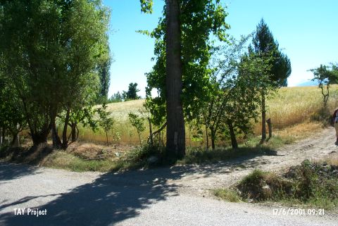
| Location: This site lies 25 km northwest of the city of Antalya; 23-25 km southwest of the town of Elmali and 1 km southeast of the village of Akçay. |
| Geography and Environment: The diameter of the Akçay I mound; which lies on the Elmali Plain; is 125 m. It is reported that the mound is flat but its height has not been given. The surface has been leveled by continuous plowing. A stream flows east and north of the mound. The name Akçay I was given by the researchers. |
| Destruction Details: The mound has been damaged due to agricultural activities and the dirt road cutting it in to two. It is cultivated and surrounded by trees [TAYEx 17.6.2001]. |