| ©The Archaeological Settlements of Turkey - TAY Project | ||||||
|
|
||||||
Boz 1 / Bozhöyük |
||||||
|
|
||||||
| Ages | Maps | Photos | ||||
| Neolithic EBA IA |
 |
 |
||||
|
|
||||||
|
Type:
|
Mound | |||||
|
Altitude:
|
100 m | |||||
|
Diameter:
|
m- Direction: | |||||
|
|
||||||
|
Region:
|
Mediterranean | |||||
|
Province:
|
Adana | |||||
|
District:
|
Ceyhan | |||||
|
Village:
|
Günyazi | |||||
|
|
||||||
|
Destruction :
|
Agriculture | |||||
|
|
||||||
|
TAYEx:
|
Visited - 31/7/2001 | |||||
|
|
||||||
|
Registration State:
|
Registered For detailed registration information please refer to Turkish pages. | |||||
 |
||||||
| Location: This site lies north of the dirt road that goes from the Günyazi (Veysiye) Train Station to the village of Yassica; between the railroad tracks and the Ceyhan-Toprakkale highway; northeast of the town of Ceyhan and east of the city of Adana. |
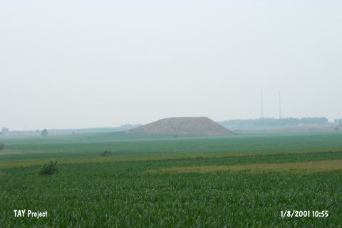
| Geography and Environment: The site is one of the important mounds in the upper Çukurova Valley. There appears to be two mounds; side by side. One is a flat-topped; stepped hill which is 40 m high; while the western one is only 15 m in height. When the site was surveyed in 1951; it was reported that these hills were used for planting crops. |
| Destruction Details: The mound has been damaged due to agricultural activities. Top of the mound is leveled. Fields start from the skirts and the western hill is completely planted [TAYEx 31.7.2001]. |