|
©The Archaeological Settlements of Turkey - TAY Project
|
|
|
|
|
|
Boz 1 / Bozhöyük |
|
|
For site maps and drawings please click on the picture...  |
For photographs please click on the photo... 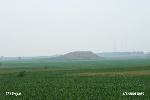 |
|
Type:
|
Mound |
|
Altitude:
|
100 m |
|
Region:
|
Mediterranean |
|
Province:
|
Adana |
|
District:
|
Ceyhan |
|
Village:
|
Günyazi |
|
Investigation Method:
|
Survey |
|
Period:
|
Ceramic |
|
|
|
 |
|
| Location: This site lies north of the dirt road that goes from the Günyazi (Veysiye) Train Station to the village of Yassica; between the railroad tracks and the Ceyhan-Toprakkale highway; northeast of the town of Ceyhan and east of the city of Adana. |
| Geography and Environment: The site is one of the important mounds in the upper Çukurova Valley. There appears to be two mounds; side by side. One is a flat-topped; stepped hill which is 40 m high; while the western one is only 15 m in height. When the site was surveyed in 1951; it was reported that these hills were used for planting crops. |
| History: |
| Research and Excavation: The site was discovered by M.V. Seton-Williams in 1951 during the surface survey he conducted of the Cilician Region. It takes place in the registered archaeological sites list prepared by Ministry of Culture and Tourism. |
| Stratigraphy: Seton-Williams believes that there was continual settlement at the site between the Chalcolithic and the Islamic Periods. |
| Small Finds: Pottery: In his report of his "Cilician Surface Survey"; Seton-Williams mentions that he recovered pre-Halafian burnished and early painted ware at this site [Seton-Williams 1954:130]. |
| Remains: |
| Interpretation and Dating: In ASPRO; it has been reported that the finds from this site resemble the Amuq B assemblage and the finds from Yumuktepe layers XXVI-XXIV as well as Coba Höyük/Sakçegözü; Layer I material [Hours et al. 1994:87]. The finds have been dated to 7;600-7;000 BP. The size and location of the mound suggest that the earliest settlement may have been Late Neolithic-Early Chalcolithic. |