|
©The Archaeological Settlements of Turkey - TAY Project
|
|
|
|
|
|
Boz 1 / Bozhöyük |
|
|
For site maps and drawings please click on the picture...  |
For photographs please click on the photo... 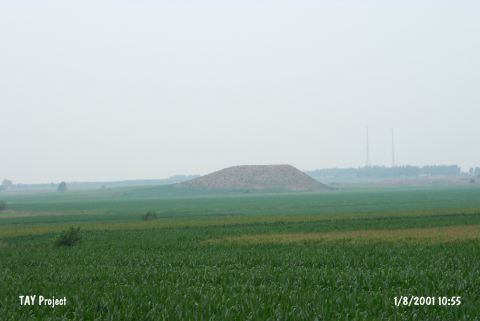 |
|
Type:
|
Mound |
|
Altitude:
|
100 m |
|
Region:
|
Mediterranean |
|
Province:
|
Adana |
|
District:
|
Ceyhan |
|
Village:
|
Günyazi |
|
Investigation Method:
|
Survey |
|
Period:
|
|
|
|
|
 |
|
| It lies immediate north of the road running from the Veyseye station to Yassica Village; south of the Ceyhan-Toprakkale railway; 15 km west of Toprakkale; east of Adana Province. Being twin mounds adjacent to each other; one is 40 m high together with the natural elevation while the other is 15 m high. It was discovered in 1951 during the Cilicia Survey conducted by M.V. Seton-Williams. Several sherds dating from the Chalcolithic Age to the Islamic Period were collected from the surface. It is included in the distribution map for metallic wares dating to the EBA by J. Mellaart. It takes place in the registered archaeological sites list prepared by Ministry of Culture and Tourism. |
| Location: This site lies north of the dirt road that goes from the Günyazi (Veysiye) Train Station to the village of Yassica; between the railroad tracks and the Ceyhan-Toprakkale highway; northeast of the town of Ceyhan and east of the city of Adana. |
| Geography and Environment: The site is one of the important mounds in the upper Çukurova Valley. There appears to be two mounds; side by side. One is a flat-topped; stepped hill which is 40 m high; while the western one is only 15 m in height. When the site was surveyed in 1951; it was reported that these hills were used for planting crops. |
| History: |
| Research and Excavation: |
| Stratigraphy: |
| Small Finds: |
| Remains: |
| Interpretation and Dating: |