| ©The Archaeological Settlements of Turkey - TAY Project | ||||||
|
|
||||||
Beysehir Höyük C |
||||||
|
|
||||||
| Ages | Maps | Photos | ||||
| Neolithic EBA IA |
 |
 |
||||
|
|
||||||
|
Type:
|
Mound | |||||
|
Altitude:
|
1080 m | |||||
|
Diameter:
|
m- Direction: | |||||
|
|
||||||
|
Region:
|
Central Anatolia | |||||
|
Province:
|
Konya | |||||
|
District:
|
Beysehir | |||||
|
Village:
|
Sadikhaci | |||||
|
|
||||||
|
Destruction :
|
Agriculture | |||||
|
|
||||||
|
TAYEx:
|
Visited - 11/7/2001 | |||||
|
|
||||||
|
Registration State:
|
For detailed registration information please refer to Turkish pages. | |||||
 |
||||||
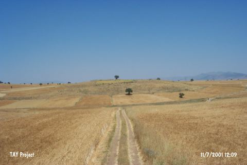
| Location: This site lies south of Eflatunpinar; approximately 6 km west of Sadikhaci Village; north of the town of Beysehir; west-southwest of the city of Konya. |
| Geography and Environment: This site referred to as Eflatun Höyük by Solecki is also known as Kocadere Höyük. In archaeological literature; the name Beysehir Höyük C seems to predominate. The dimensions of the mound are not reported. |
| Destruction Details: The mound has been damaged due to agricultural activities. Some parts have been leveled and cut and the skirts completely planted [TAYEx 11.7.2001]. |