| ©The Archaeological Settlements of Turkey - TAY Project | ||||||
|
|
||||||
Tavsan Adasi |
||||||
|
|
||||||
| Ages | Maps | Photos | ||||
| Chalcolithic IA Greek-Roman |
 |
 |
||||
|
|
||||||
|
Type:
|
Mound | |||||
|
Altitude:
|
0 m | |||||
|
Diameter:
|
m- Direction: | |||||
|
|
||||||
|
Region:
|
Aegean | |||||
|
Province:
|
Aydin | |||||
|
District:
|
Söke | |||||
|
Village:
|
Tavsan Adasi | |||||
|
|
||||||
|
Destruction :
|
Natural causes | |||||
|
|
||||||
|
TAYEx:
|
Visited - 24/9/2000 | |||||
|
|
||||||
|
Registration State:
|
Registered For detailed registration information please refer to Turkish pages. | |||||
 |
||||||
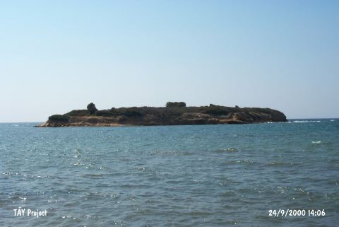
| Location: The mound lies northwest of Aydin; 10 km northwest of Didim; north of the mouth of Mersinli stream at the Aegean shore. It is located right across Ministry of Environment and Forestry Recreation Area; on an islandÑ that used to be a peninsula until recentlyÑ 80 m from the coast line; today. |
| Geography and Environment: The island measures 100 m in the northwest- southeast direction; 50 m in the northeast-southwest direction and 8 m in height. The profile of the settlement became visible as they were worn by the waves along the coast. The small mound lies in the middle of the island. Stone walls on the lower terraces of the mound can be traced from time to time due to erosion caused by waves. |
| Destruction Details: |