|
©The Archaeological Settlements of Turkey - TAY Project
|
|
|
|
|
|
Tavsan Adasi |
|
|
For site maps and drawings please click on the picture...  |
For photographs please click on the photo... 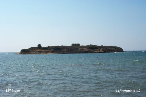 |
|
Type:
|
Mound |
|
Altitude:
|
0 m |
|
Region:
|
Aegean |
|
Province:
|
Aydin |
|
District:
|
Söke |
|
Village:
|
Tavsan Adasi |
|
Investigation Method:
|
Excavation |
|
Period:
|
|
|
|
|
 |
|
| Location: The mound lies northwest of Aydin; 10 km northwest of Didim; north of the mouth of Mersinli stream at the Aegean shore. It is located right across Ministry of Environment and Forestry Recreation Area; on an islandÑ that used to be a peninsula until recentlyÑ 80 m from the coast line; today. |
| Geography and Environment: The island measures 100 m in the northwest- southeast direction; 50 m in the northeast-southwest direction and 8 m in height. The profile of the settlement became visible as they were worn by the waves along the coast. The small mound lies in the middle of the island. Stone walls on the lower terraces of the mound can be traced from time to time due to erosion caused by waves. |
| History: |
| Research and Excavation: The excavations and surveys in Tavşan Island under the scope of Didyma Excavations are carried out by Furtwängler between 26.08 Ğ 02.10.2009. The research covered an area of 550 square meters at different layers under the scope of these studies [Furtwängler 2011: 33]. |
| Stratigraphy: The layering of the site can be traced as the following: A community is settled here during Early Bronze Age (TA2) associated with Asia Minor and having trade relations with Southern Aegean. The settlement is abandoned for the purposes yet unknown. Phase TA3 settlement shows some planning phases. Phases TA3 and TA4 which are in close contact with Crete-Minos world must have been inhabited by a new arriving community. Phase TA4 is destructed by med wave and this region is not inhabited during Late Bronze Age [Furtwängler 2011: 34]. |
| Small Finds: North Field: A 10 m long and 3 m wide trench is opened in the North end down to the main rock. 5 different layers can be traced in the South profile which is 1.80 m deep, under the agriculture soil layer. The latest layer is associated with a strong wall continued with a wall extending in N Ğ W direction and contains findings related with TA+ Phase (late palace period). A fire level is encountered under this layer which can be associated with a wall constructed in the same direction and contains TA3 (late palace period) findings. In both cases walls are 0.62 m thick and delicately processed adobe wall remains are encountered. This is followed by a 0.30 m thick layer that is not associated with the architectural structure and contains few findings. Two collapsed layers with a characteristic soil and associated with architectural structures exist beneath this layer until the main rock. This layer is distinguished as TA2 as opposed to TA3 and TA4 phases, and although it contains a few imported Crete and Cyclad influenced potteries, it presents Anatolian associated potteries in general. The percentage of wheel-made potteries drop as the excavation goes deeper. The parallels of Anatolia/Troia point to Early Bronze Age for both layers. The walls of both of the Structure l phases are made with small stones and are only 0.40 m thick. A child burial is encountered which is eroded within the room belonging to TA2b phase right under the walking level in the slope profile. South Part: The work on the structures that belong to Crete Palace Period which were excavated in 2008 continued in the South Part. Although it is not possible to sketch a plan because of the destruction caused by the removal of stones, well preserved walls and traceable adobe walls suggest a large building complex. The type of the architecture and the rooms and the TA3 period findings captured in the internal yard can be associated with Crete-Manos world. Another early period layer is detected in B13 section. This is a typical Western Anatolian megaron-type building made of small stones having 0.40 thick walls. When observed from North drill we are faced with a building that belongs to Phase TA2b. Southeast Part: A building from Late Crete Palace Period with its remarkable dimensions can be traced. This is a building with almost a square plan (15.5 by 15 m) having a sophisticated internal plan. The rooms unearthed so far are two floored storage rooms. Some evidences are encountered suggesting that the building was destructed due to a tidal wave [Furtwängler 2011: 33]. |
| Remains: |
| Interpretation and Dating: |