|
©The Archaeological Settlements of Turkey - TAY Project
|
|
|
|
|
|
Tavsan Adasi |
|
|
For site maps and drawings please click on the picture...  |
For photographs please click on the photo... 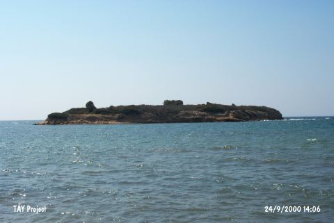 |
|
Type:
|
Mound |
|
Altitude:
|
0 m |
|
Region:
|
Aegean |
|
Province:
|
Aydin |
|
District:
|
Söke |
|
Village:
|
Tavsan Adasi |
|
Investigation Method:
|
Excavation |
|
Period:
|
|
|
|
|
 |
|
| Location: The mound lies northwest of Aydin; 10 km northwest of Didim; north of the mouth of Mersinli stream at the Aegean shore. It is located right across Ministry of Environment and Forestry Recreation Area; on an islandÑ that used to be a peninsula until recentlyÑ 80 m from the coast line; today. |
| Geography and Environment: The island measures 100 m in the northwest- southeast direction; 50 m in the northeast-southwest direction and 8 m in height. The profile of the settlement became visible as they were worn by the waves along the coast. The small mound lies in the middle of the island. Stone walls on the lower terraces of the mound can be traced from time to time due to erosion caused by waves. |
| History: |
| Research and Excavation: The excavations and surveys in Tavsan Island under the scope of Didyma Excavations are carried out by Furtwängler. |
| Stratigraphy: During the excavations carried out in the island, 7 layers have been identified. TA7 Ottoman Period TA6 Late Antiquity / Early Byzantine TA5 Archaic Period TA4 Late Palace Period of Crete TA3 Old Palace Period of Crete and Miletus 3 TA2 EBA - MBA TA1 Chalcolithic |
| Small Finds: |
| Remains: During the studies carried out on the east of the island in 2010, a wall remains and a pit containing bowls with birds, black-glazed wares, fikellura sherds etc.; which is probably related with the wall; belonging to Archaic Period were encountered on the north shore. This findings gives information about the Archaic Period settlement which its remains were presumably vanished on the shore [Furtwangler 2013:156]. |
| Interpretation and Dating: |