| ©The Archaeological Settlements of Turkey - TAY Project | ||||||
|
|
||||||
Semsiyetepe |
||||||
|
|
||||||
| Ages | Maps | Photos | ||||
| Chalcolithic EBA IA |
 |
 |
||||
|
|
||||||
|
Type:
|
Mound | |||||
|
Altitude:
|
650 m | |||||
|
Diameter:
|
m- Direction: | |||||
|
|
||||||
|
Region:
|
Eastern Anatolia | |||||
|
Province:
|
Elazig | |||||
|
District:
|
Baskil | |||||
|
Village:
|
Bilalusagi | |||||
|
|
||||||
|
Destruction :
|
Dams | |||||
|
|
||||||
|
TAYEx:
|
Visited - 22/7/2003 | |||||
|
|
||||||
|
Registration State:
|
For detailed registration information please refer to Turkish pages. | |||||
 |
||||||
| Location: The mound is located at Kumlu Mevkii; 500 m south of the Bilalusagi Village of Baskil District; west of the Elazig Province [Darga 1987:291]. It can be reached through the motorway running from Baskil to the west. The former village of Bilalusagi was flooded by the Karakaya Dam. It is coded under 0 50 /10. |
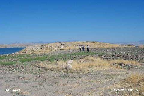
| Geography and Environment: It stands on a conglomeratic hill on the first terrace of the Euphrates. It is a small and round hill measuring 5-6 m in height and 70x90 m in dimensions. M. Darga claims that it is one of the medium sized mounds in the region [Darga 1984:91]. The northern and northwestern parts of the hill have been damaged as the former terrace was partly eroded by the Euphrates. The western and northwestern parts of the mound are expected to be influenced only during the seasons the waters of the lake rise. At present; it is located on a peninsula extending to the lake. A 3/4 portion of the mound is reported to be submerged [Darga 2000:140]. The damage caused by the modern villages still went on during the excavations. The team arrived to the hill for the 1987 excavation was amazed to see that the architectural remains uncovered during the previous years were removed by the local villagers to erect walls of their houses [Darga 1989:181]. |
| Destruction Details: The mound has been partly damaged by dam reservoir [TAYEx 22.7.2003]. |