|
©The Archaeological Settlements of Turkey - TAY Project
|
|
|
|
|
|
Semsiyetepe |
|
|
For site maps and drawings please click on the picture...  |
For photographs please click on the photo... 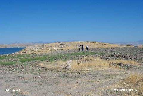 |
|
Type:
|
Mound |
|
Altitude:
|
650 m |
|
Region:
|
Eastern Anatolia |
|
Province:
|
Elazig |
|
District:
|
Baskil |
|
Village:
|
Bilalusagi |
|
Investigation Method:
|
Excavation |
|
Period:
|
EBA III EBA II |
|
|
|
 |
|
| Location: The mound is located at Kumlu Mevkii; 500 m south of the Bilalusagi Village of Baskil District; west of the Elazig Province [Darga 1987:291]. It can be reached through the motorway running from Baskil to the west. The former village of Bilalusagi was flooded by the Karakaya Dam. It is coded under 0 50 /10. |
| Geography and Environment: It stands on a conglomeratic hill on the first terrace of the Euphrates. It is a small and round hill measuring 5-6 m in height and 70x90 m in dimensions. M. Darga claims that it is one of the medium sized mounds in the region [Darga 1984:91]. The northern and northwestern parts of the hill have been damaged as the former terrace was partly eroded by the Euphrates. The western and northwestern parts of the mound are expected to be influenced only during the seasons the waters of the lake rise. At present; it is located on a peninsula extending to the lake. A 3/4 portion of the mound is reported to be submerged [Darga 2000:140]. The damage caused by the modern villages still went on during the excavations. The team arrived to the hill for the 1987 excavation was amazed to see that the architectural remains uncovered during the previous years were removed by the local villagers to erect walls of their houses [Darga 1989:181]. |
| History: |
| Research and Excavation: It was first introduced by K. Kökten as Semsi Höyük during the 1945 survey [Kökten 1947:464]; and re-documented during a survey conducted by TEKDAM under M. Özdogan. Although it would not have been submerged; it was excavated from 1978 under A.M. Darga; University of Istanbul under the research project conducted by the METU Research Center of Salvage and Evaluation of Ancient Monuments (TEKDAM). The excavation was terminated in 1987. Ten years later than the starting date due to the flooding of the village of Bilalusagi and difficult conditions arose in the region. |
| Stratigraphy: As a result of the excavations; the cultural stratification is presented by M. Darga as follows; Levels 1-2: Remains of Roman Period fortress Level 3: Middle Iron Age (rare finds of Urartu Period only on the northwestern part) Level 4: Late Bronze Age Level 5: Middle Bronze Age I (transition period from EBA III to MBA) Levels 6-9: Building levels III A; III B; II A; II B of EBA Levels 10-11: Late Chalcolithic Age/EBA I (?) |
| Small Finds: Architecture: All building levels of EBA II and III are evaluated in the same cultural context since the changes are minimal both in the directions and the techniques. These settlements dating to the second half of the third millennium BC yielded constructions consisting of rectangular rooms in an adjacent plan. Walls of the houses were built of a mixture of small stones from flooded sections; a local limestone; and loam mortar. Thickness of the walls is around 40 cm. Corners are; sometimes; rounded. Walls are plastered and painted with a filthy white material. The roof is assumed to be of a light material. The rooms interconnected with passages and the courtyards house horseshoe-like hearths with ash places. Some walls are attached with seating and sleeping benches of mudbrick; 45x50 cm in dimensions. The plan of the architectural remains uncovered revealed that the kilns in the big area on the west have been severely damaged [Darga 1989:182]. Evidences of wooden pillars indicate that this area was partly covered with an apprentice. Only the northern wall of the house called "South House" on the southwest was uncovered. This house stands on the virgin soil. It was built during EBA II like the other EBA constructions. The deep stone foundations of the Roman fortress have destroyed this part very much. On the southwestern pebbled shore of the mound; a domed kiln for pottery firing with a horseshoe-like floor was uncovered. The presence of packsaddle-like stands provided evidence for the pottery firing in this kiln. Measuring 150x70 cm in dimensions; it is located in an area where; probably; painted ware of Malatya-Elazig was produced. M. Darga proposes that there are constructions of fence-built units with plastered mudbricks during the EBA I [Darga 1984:96]. No drawing of plans outlining the architectural phases was provided in the excavation reports. Pottery: It is reported that sherds of Karaz; painted ware and fine ware constitute a vast majority of the pottery recovered from the building levels dating to EBA [Darga 1986b:74-76] [Darga 2000:144-145]. Surface color of the handmade Karaz ware with straw and grit tempered paste is black; dark gray or red. They are very well burnished. Forms of bowls with unrolled rims; dishes and short-necked vessels are made of this ware [Darga 1987:293]. Patterns of zigzag; concentric angles; grains of wheat or grapes; combed decoration applied by incision decoration techniques were employed [Darga 2000:145]. Samples of paint decorated ware are elaborately handmade. The paste is tempered with mica; grit and calcareous grit after thinning. Mottled by itself; the surface of the ware is cream; pinkish cream and slightly green beige decorated by matt black; matt dark brown; tile red paints [Darga 1986b:75] [Darga 2000:144]. Traces of brush can be observed in painting decorations. As decorations; patterns identical to Karaz ware like net-design; wavy lines; hatched triangles and zigzags between horizontal parallel bands; thin bands and horizontal bands are popular. Aside these geometrical patterns; rarely found are plant patterns. M. Darga informs that the decorations like turning wheel; stylized sun; big dots; bow and comb-like adornments can be signs representing the potters of the ateliers [Darga 1986b:76]. The excavator reports that the whole vessel used to be painted; and then decorated in bands by incision during the last phase of EBA. It was slightly burnished and moderately fired after the decoration. Decorated ware is not rich in forms. Common forms are jug; bowl; dish; spouted bowl and pithos. Through the lower levels of the mound; the number of decorated ware decreases while the number of Karaz ware samples increases. The ware identified as third group of ware by M. Darga is a ware known as fine ware in the Elazig region. It is wheel-made; fine pasted in pink-beige colors; surface color same as the color of the paste. Small bowls and dishes are of this ware [Darga 1986b:78]. It is reported that wheel-made; bright gray colored; metallic-like ware identified as Akkads ware originated from Northern Mesopotamia and the North Syrian ware of wavy lines are represented by a few samples [Darga 2000:145]. Also found are coarse kitchen ware recovered from both the EBA levels and the transition level from EBA III to MBA I. Clay: M. Darga doesn't provide much information about the small finds of Semsiyetepe. Only the presence of a "çeç" seal is an indication of a community dependent on agriculture [Darga 1983:57]. Ground Stone: One of the building levels dating to EBA yielded a mace in white marble of 12 cm; the hole in the center not finished [Darga 1986a:122] and a hammer/axe in green stone (serpentine). |
| Remains: |
| Interpretation and Dating: The excavations lasted for a longer period of time compared to the other mounds excavated in Anatolia yielded a fortress (?) of Roman Period; other than an EBA settlement which revealed a pottery culture dominated by painted pottery seen at all the settlements along the Euphrates. The settlements built of stone and mudbrick wall on a stone socle; probably; in an adjacent plan have destroyed each other in addition to the damage caused by the upper Roman fortress. Therefore; exact information was not obtained about this age. The mound should be evaluated within the cultural group of EBA II and III settlements in the Elazig-Malatya region like Tepecik; Korucutepe; Degirmentepe and Norsuntepe. |