|
©The Archaeological Settlements of Turkey - TAY Project
|
|
|
|
|
|
Semsiyetepe |
|
|
For site maps and drawings please click on the picture...  |
For photographs please click on the photo... 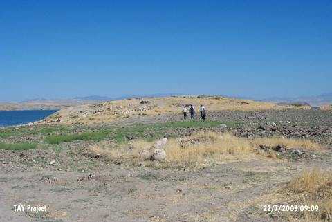 |
|
Type:
|
Mound |
|
Altitude:
|
650 m |
|
Region:
|
Eastern Anatolia |
|
Province:
|
Elazig |
|
District:
|
Baskil |
|
Village:
|
Bilalusagi |
|
Investigation Method:
|
Excavation |
|
Period:
|
|
|
|
|
 |
|
| Location: The mound is located at Kumlu Mevkii; 500 m south of the Bilalusagi Village of Baskil District; west of the Elazig Province [Darga 1987:291]. It can be reached through the motorway running from Baskil to the west. The former village of Bilalusagi was flooded by the Karakaya Dam. It is coded under 0 50 /10. |
| Geography and Environment: It stands on a conglomeratic hill on the first terrace of the Euphrates. It is a small and round hill measuring 5-6 m in height and 70x90 m in dimensions. M. Darga claims that it is one of the medium sized mounds in the region [Darga 1984:91]. The northern and northwestern parts of the hill have been damaged as the former terrace was partly eroded by the Euphrates. The western and northwestern parts of the mound are expected to be influenced only during the seasons the waters of the lake rise. At present; it is located on a peninsula extending to the lake. A 3/4 portion of the mound is reported to be submerged [Darga 2000:140]. The damage caused by the modern villages still went on during the excavations. The team arrived to the hill for the 1987 excavation was amazed to see that the architectural remains uncovered during the previous years were removed by the local villagers to erect walls of their houses [Darga 1989:181]. |
| History: |
| Research and Excavation: The settlement was first introduced as Semsi Höyük by K. Kökten during the surveys conducted in 1945 [Kökten 1947:464] and was documented again during the survey conducted under the direction of M. Özdogan for TEKDAM. Although it was not subject to flooding of reservoir waters, it was excavated by the METU Research Center of Salvage and Evaluation of Historical Finds (TEKDAM) within the Lower Euphrates Project starting from 1978 under the direction of A.M. Darga of Istanbul University. The excavations were terminated ten years after initiation of excavations in 1987 because of challenging working conditions when the Bilalusagi Village was submerged. |
| Stratigraphy: Eleven building levels were identified during the excavations in this 6 m high mound which measures 90 X 70 m in dimensions: Levels 1-2: Roman Period garrison fortress Level 3: Middle Iron Age (limited number of Urartu Period finds only in the northwestern section) Levbel 4: Late Bronze Age Level 5: Middle Bronze Age I (transition from EBA III to MBA) Levels 6-9: Early Bronze Age building levels III A, III B, II A, II B Levels 10-11: Late Chalcolithic Age/Early Bronze Age phase I (?) |
| Small Finds: Architecture: The Early Bronze and Middle Bronze levels yielded rectangular domestic buildings, which are adjacent to each other, sharing a common plan. To the northwest of Semsiyetepe on the side of the Euphrates, an open courtyard of 5,5x7,5 m was unearthed, corners of the walls being slightly rounded. The Middle Iron Age finds have been heavily destroyed. Remains of a stone wall unearthed under Iron Age finds reaches a height of 1.10 m. A 5 m part of the wall was exposed, bearing traces of the collapse of overlaying heavy buildings. Pottery: Based on the analysis of sherds, presence of a mainly Early Bronze Age settlement was identified in the site. Geometric paint decoration on very light background is very common in the north-south section. In this area also found are red slipped, burnished sherds and amorphous fragments of other familiar Urartian vessels. These vessels represent the distinctive features of the Urartu culture at Semsiyetepe. Rare specimens of wheelmade metallic-like ware in bright grey described as Mesopotamian and Akkadian pottery were also uncovered. Also found are wavy line decorated ceramics known from the excavation sites in North Syria. Stone: The present gulley was used for stone breaking. Hammers made of hard volcanic stones were uncovered. They were found either in rooms or among the courses of stones in walls. Figurine: Terracotta, paint-decorated figurines of stylized women, ram and bird heads with a bell-shaped bottom described as idols were found in the domestic buildings from the late phase of the Early Bronze Age at Semsiyetepe. The Urartian sherds dating to the Iron Age (7th century bright, dark red) were found on the Urartian floor in trench AAII. It is observed that the whole group uncovered from the ground level down to a depth of 2-2.80 m in trenches A,B,C and AA, BB, CC of plan squares K-L-M 5-6 corresponding to the peak of Semsiyetepe Höyük were all paint decorated. The Iron Age pottery found mixed with the Early Bronze Ages (III ve II) on the ground were found down to a depth of 50 cm in the excavation area; among them are various wheelmade Iron Age sherds with grooves under the rim known from Altinova in addition to an Urartian bowl fragment recovered from trench AAI. A depth of almost 1 m was reached in an area (4 squares of 5x5 m) from the hilltop down until the eastern skirts. These trenches yielded mixed Iron Age and Early Bronze Age sherds within the depression deposit. Also found is a bowl that belongs to the Karaz culture. |
| Remains: |
| Interpretation and Dating: The Semsiyetepe excavations display a distinct view with emergence of new finds witnessing the relationship between Anatolia and North Mesopotamia during the 3rd Millennium BC including new and authentic finds of the local Altinova culture, particularly terracotta deity figurines, domestic buildings built with stone walls and paint decorated pottery. Considering these, it is obvious that the salvage excavations conducted at Semsiyetepe are significant in terms of the history of the Anatolian culture. The stone masonry of domestic structures, painted pottery composing a majority of small finds, and finds related with the Iron Age and Karaz culture uncovered at Semsiyetepe are of high importance. The sherds uncovered at Semsiyetepe bear Urartian pottery characteristics. The excavations revealed that the Middle Iron Age building level had been destroyed. |