| ©The Archaeological Settlements of Turkey - TAY Project | ||||||
|
|
||||||
Sarhöyük / Dorylaion |
||||||
|
|
||||||
| Ages | Maps | Photos | ||||
| EBA IA |
 |
 |
||||
|
|
||||||
|
Type:
|
Mound | |||||
|
Altitude:
|
814 m | |||||
|
Diameter:
|
m- Direction: | |||||
|
|
||||||
|
Region:
|
Central Anatolia | |||||
|
Province:
|
Eskisehir | |||||
|
District:
|
Merkez | |||||
|
Village:
|
Muttalip | |||||
|
|
||||||
|
|
||||||
|
|
||||||
|
TAYEx:
|
Visited - 28/6/2002 | |||||
|
|
||||||
|
Registration State:
|
Registered For detailed registration information please refer to Turkish pages. | |||||
 |
||||||
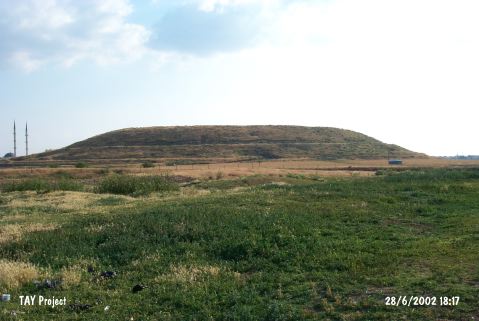
| Location: The ancient city of Dorylaion, modern Sarhöyük, is situated on the southern edge of a plain to the north of the Porsuk Brook, 2 km from Porsuk Brook near the Muttalip Subdistrict, 3 km northeast of the provincial center of Eskisehir. According to the ancient resources, it is a Phrygian city founded by Dorylaeus of Eretria. |
| Geography and Environment: Sarhöyük-Dorylaion is a crossroads of primarily important routes that provide access from the Central Anatolia to the Marmara Sea, the Aegean shores and the Mediterranean Region. It is referred as a prosperous trading city renowned with its thermal waters. It has a height of 18 m and a diameter of 450 m, and it is one of the moderate sized mounds of the Central Anatolia. It has been heavily destroyed by the pits dug for artillery batteries in Eskisehir during the Independence War. |
| Destruction Details: |