|
©The Archaeological Settlements of Turkey - TAY Project
|
|
|
|
|
|
Sarhöyük / Dorylaion |
|
|
For site maps and drawings please click on the picture...  |
For photographs please click on the photo... 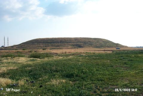 |
|
Type:
|
Mound |
|
Altitude:
|
814 m |
|
Region:
|
Central Anatolia |
|
Province:
|
Eskisehir |
|
District:
|
Merkez |
|
Village:
|
Muttalip |
|
Investigation Method:
|
Excavation |
|
Period:
|
EBA III |
|
|
|
 |
|
| It is located 2 km far from the Porsuk Stream; near Muttalip Village; 3 km northeast of Eskisehir Province. It is a round mound; 450 m in diameter. It was considerably damaged by the bastion pits opened during the war. It was excavated by a team under M. Darga. During the surface collection; sherds representing the transition ware from EBA to MBA were recovered from the surface and the lower eight stairs of a stepped trench aiming to find out the stratification of the mound. Darga compares this material with the Level III of Demircihöyük. A very restricted number of spindle-whorls in terra cotta was recovered as well as blades in flintstone [Darga 1994:484; 487-488; pic.12b; e; g]. It takes place in the registered archaeological sites list prepared by Ministry of Culture and Tourism. The studies carried out so far yielded no remains belonging to EBA levels. However, especially during the excavations conducted in the levels belonging to Hellenistic and Phrygian periods, a great number of EBA III wares, baked clay figurines and spindle whorls were found in the pits and fills. Among them, a baked clay mother goddess figurine recovered from the rubbish pit in the Phrygian level is quite noteworthy. Also, the stylized goat and ram figurine found in the fill share similarities with the ones known from Demircihöyük settlement [Sivas-Sivas 2014:156]. |
| Location: The ancient city of Dorylaion, modern Sarhöyük, is situated on the southern edge of a plain to the north of the Porsuk Brook, 2 km from Porsuk Brook near the Muttalip Subdistrict, 3 km northeast of the provincial center of Eskisehir. According to the ancient resources, it is a Phrygian city founded by Dorylaeus of Eretria. |
| Geography and Environment: Sarhöyük-Dorylaion is a crossroads of primarily important routes that provide access from the Central Anatolia to the Marmara Sea, the Aegean shores and the Mediterranean Region. It is referred as a prosperous trading city renowned with its thermal waters. It has a height of 18 m and a diameter of 450 m, and it is one of the moderate sized mounds of the Central Anatolia. It has been heavily destroyed by the pits dug for artillery batteries in Eskisehir during the Independence War. |
| History: |
| Research and Excavation: |
| Stratigraphy: |
| Small Finds: |
| Remains: |
| Interpretation and Dating: |