| ©The Archaeological Settlements of Turkey - TAY Project | ||||||
|
|
||||||
Suberde / Görüklük Tepe |
||||||
|
|
||||||
| Ages | Maps | Photos | ||||
| Neolithic 14C |
 |
 |
||||
|
|
||||||
|
Type:
|
Mound | |||||
|
Altitude:
|
1050 m | |||||
|
Diameter:
|
m- Direction: | |||||
|
|
||||||
|
Region:
|
Central Anatolia | |||||
|
Province:
|
Konya | |||||
|
District:
|
Seydisehir | |||||
|
Village:
|
Gölyüzü | |||||
|
|
||||||
|
|
||||||
|
|
||||||
|
TAYEx:
|
Visited - 10/7/2001 | |||||
|
|
||||||
|
Registration State:
|
Registered For detailed registration information please refer to Turkish pages. | |||||
 |
||||||
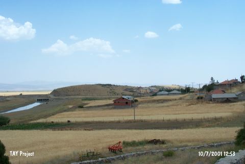
| Location: The site lies southwest of the city of Konya; 1 km southeast of the town of Seydisehir; 500 m east of the village of Suberde. |
| Geography and Environment: The mound lies on a 700 m long; 70 m wide and 30 m high limestone outcrop which is located northwest of Lake Sugla. The cultural material deposit of the mound is between 3.5 and 4 m. The site has not been named Görülük after the limestone outcrop but Suberde after the closest village. Artifacts were found in a 5;000 square meter area. There are occasional patches of soil on the upper side of the limestone outcrop where the mound is located. The mound lies at the beginning of a valley which is oriented northwest-southeast. It is thought that this site was located immediately beside Lake Sugla (now almost completely dried); in the transitional period between the Pleistocene and the Holocene. The environment is characteristically steppe. The low mountains are rich in hunt animals. The inhabitants of the site must have used the nearby hills for hunting and the surrounding soils for agriculture. The site of Görüklük Tepe was chosen by early agricultural societies; probably because environmental and geological conditions were suitable. |
| Destruction Details: |