|
©The Archaeological Settlements of Turkey - TAY Project
|
|
|
|
|
|
Suberde / Görüklük Tepe |
|
|
For site maps and drawings please click on the picture...  |
For photographs please click on the photo... 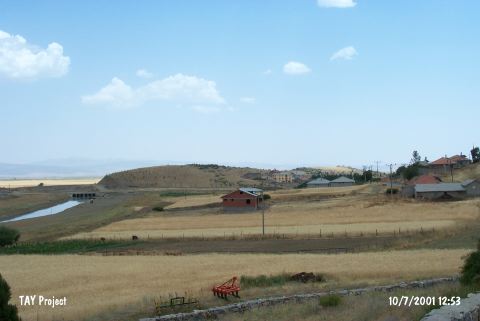 |
|
Type:
|
Mound |
|
Altitude:
|
1050 m |
|
Region:
|
Central Anatolia |
|
Province:
|
Konya |
|
District:
|
Seydisehir |
|
Village:
|
Gölyüzü |
|
Investigation Method:
|
Excavation |
|
Period:
|
Aceramic Ceramic |
|
|
|
 |
|
| Location: The site lies southwest of the city of Konya; 1 km southeast of the town of Seydisehir; 500 m east of the village of Suberde. |
| Geography and Environment: The mound lies on a 700 m long; 70 m wide and 30 m high limestone outcrop which is located northwest of Lake Sugla. The cultural material deposit of the mound is between 3.5 and 4 m. The site has not been named Görülük after the limestone outcrop but Suberde after the closest village. Artifacts were found in a 5;000 square meter area. There are occasional patches of soil on the upper side of the limestone outcrop where the mound is located. The mound lies at the beginning of a valley which is oriented northwest-southeast. It is thought that this site was located immediately beside Lake Sugla (now almost completely dried); in the transitional period between the Pleistocene and the Holocene. The environment is characteristically steppe. The low mountains are rich in hunt animals. The inhabitants of the site must have used the nearby hills for hunting and the surrounding soils for agriculture. The site of Görüklük Tepe was chosen by early agricultural societies; probably because environmental and geological conditions were suitable. |
| History: |
| Research and Excavation: The site was discovered in 1963 by R. Solecki during the "Beysehir-Sugla Lakes; Surface Survey" of Colombia University. Excavations at the site were conducted between 1964-65 under the direction of J. Bordaz. The site was of interest because of its unusual chipped stone assemblage as reported by Solecki. Bordaz' archaeological excavation was concentrated on the eastern part of the mound. It takes place in the registered archaeological sites list prepared by Ministry of Culture and Tourism. |
| Stratigraphy: The excavations led by Bordaz exposed a total of three layers [Bordaz 1969:44; fig. 3-4 cross-sectional trench profiles]. Layer I: (Surface layer) Ottoman; Byzantine; Roman; Hellenistic; Phrygian; Bronze Ages Layer II: Upper Prehistoric Layer/Aceramic Neolithic Period Layer III: Lower Prehistoric Layer/Aceramic Neolithic Period Layer IV: Virgin soil; sterile. |
| Small Finds: Architecture: It has been determined that there are a number of square mudbrick houses in Layer II. Stone foundations were used in some buildings. Although most of the mudbrick walls were collapsed; some walls had been preserved as high as eight or nine rows. This allowed for understanding wall construction techniques. The mudbricks were held together with clay mortar. It cannot be ascertained whether there was mortar on the walls. Room floors; on the other hand; have been lined with stones and then plastered. The same architectural building techniques and characteristic elements were present in the earlier layer; Layer III. The main building material is mudbrick. Pits constructed 15-20 m above room floors; thought to be used for storage; have been found. The fact that some of them have been plastered with an ash suggests that they may have functioned as fire pits. Pottery: Very few ceramics were found in the lower levels of the site. This suggests that these peoples lived in a time when ceramic production existed. The upper part of Layer III yielded five Neolithic sherds while twelve sherds were found in Layer I [Bordaz 1969:51]. The ceramics found in both layers are the same type of ware; which is organic-tempered and thick-walled. The surface color of the ware is pink. The profile of the vessels appears to have flaring rims. Forms are mostly closed. Bordaz reports that the inhabitants of Layer III produced ceramics but that the inhabitants of the following later layer; Layer II; gave this up. Three major ceramics' tradition were observed among the sherds revealed at Suberde. These were identified as "Early, Mid and Late Traditions" based on the cultural sequence and classical terminology. This sequence is the similar of Çatalhöyük ve Erbaba [Özdöl 2008:377]. Clay: Poorly baked clay objects have been found at Görüklük Tepe since the earliest layers. The fact that conical objects were found in addition to human and animal figurines suggests that the inhabitants of this site were familiar with clay firing. A female figurine idol was found [Bordaz 1969:fig 24]. Animal figurines include pigs as well as bird figures [Bordaz 1969:fig.21-23]. Chipped Stone: The surface survey and excavation both yielded a large amount of chipped stone tools and debitage products. 90% of these finds are obsidian while the remaining 10% are flint. The fact that the sizes of the tools are smaller in Layer III suggests that microlith industry was still continuing at this site. Some of the tools have controlled pressure flaking. Flakes and blades are both very common. Points and scrapers were frequently found tools. Perforators and backed blades were also present. Some flint blades used as sickles were found in Layer II. The number of points increase in Layer III. The microliths tools include triangles. Ground Stone: The lower levels of the excavation yielded many polished celts [Bordaz 1969:fig:7-11]. Also; sharpening stones made to sharpen the incised decorated celts; burnishing; hammering and grinding stones were found. Decorative stones include stone beads and pierced small flat river pebbles. Bone/Antler: The majority of bone tools are bone awls of different sizes and shapes. Bone beads and pendants were also found. Fauna: All of the animal bones recovered during the excavations were collected and studied with care. Analysis determined that domestication was practiced. The most common source of meat was sheep which comprises 85% of all animal bones. Deer; fish and hare bones suggest that hunting was another method to supply food. The only difference in faunal remains between Layer II and III is that cattle percentages increase in Layer II. Sheep; goat and pig were the domesticated animal types. These animals were preferred over cattle because of their smaller sizes; practical for group grazing. Flora: Palaeological studies indicated that the long and narrow valley by Görüklük Tepe had a steppe climate and that it was hot and dry in the summers and cold and rainy in the winters. It has not been determined whether the variety of plants were domesticated. Initial surveys suggest that agriculture was practiced. Wheat; barley; peas and lentils were used in their diets. Other: Sea-products may have added to subsistence since shells of fresh-water mussels; which were probably collected from Lake Sugla were found. B. Aytug's results of the flotation samples taken from the excavation soils showed that large trees similar to the ones that grow along the Taurus Mountains today such as pine; Scotch fir pine; cedar were common in the Neolithic Period in this region [Aytug 1967:2-5]. It has been determined that water-loving trees such as willows and lindens grew in the area around Sugla Lake. |
| Remains: |
| Interpretation and Dating: 14C samples collected during the Suberde/Görüklük excavations; especially from Layer III date to (uncalibrated) 6;600-6;200±100 BC (calibrated 6;500-6;000 BC) [Bordaz 1969:59]. |