| ©The Archaeological Settlements of Turkey - TAY Project | ||||||
|
|
||||||
Sizma Höyük |
||||||
|
|
||||||
| Ages | Maps | Photos | ||||
| Chalcolithic EBA IA Greek-Roman |
 |
 |
||||
|
|
||||||
|
Type:
|
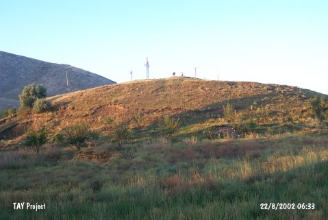
Mound | |||||
|
Altitude:
|
1550 m | |||||
|
Diameter:
|
160 m- Direction: NNW-SSE | |||||
|
|
||||||
|
Region:
|
Central Anatolia | |||||
|
Province:
|
Konya | |||||
|
District:
|
Selçuklu | |||||
|
Village:
|
Sizma | |||||
|
|
||||||
|
Destruction :
|
Contemporary Settlements - Attention | |||||
|
|
||||||
|
TAYEx:
|
Visited - 22/8/2002 | |||||
|
|
||||||
|
Registration State:
|
Registered For detailed registration information please refer to Turkish pages. | |||||
 |
||||||
| Location: It is situated witin the boundaries of the Selçuklu District in Konya. It lies approximately 25 km northwest Konya. It was founded in a valley among the mountains, approximately 12 km west of the Konya-Istanbul motorway. Lying immediately north of the present town, it measures 150x150x25 m in dimensions. |
| Geography and Environment: Sizma is situated between the ancient Lycaonia, East Phrygia and Pisidia. It is of strategical importance since it commands the valley roads leading to the mountains of the Konya Plain. To the northeast lies Karadag, to the south is Gediktepesi (1821 m), to the north rises the Mount Çaldagi, to the west is Kuzyatak, and to the southwest lies the Mount Bozdag (1823 m). Sizma was known as Zizima or Zizime during the Ancient Age. Surveys and excavations as well as characteristics of the region indicate that Sizma and its environs had been occupied starting from the prehistoric periods. Traces of occupation are observed in the caves, so called obruk by the locals, located to the southwest of the town. |
| Destruction Details: The mound has been damaged due to contemporary settlement. There are electricity poles on top hill and all of the skirts have been cut. The huge trenches on the mound made by Robinson extended by the villagers [TAYEx 22.8.2002]. |