|
©The Archaeological Settlements of Turkey - TAY Project
|
|
|
|
|
|
Sizma Höyük |
|
|
For site maps and drawings please click on the picture...  |
For photographs please click on the photo... 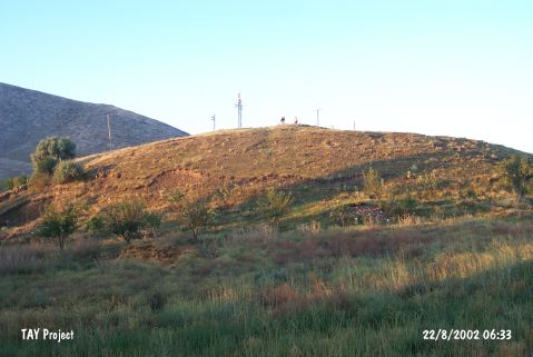 |
|
Type:
|
Mound |
|
Altitude:
|
1550 m |
|
Region:
|
Central Anatolia |
|
Province:
|
Konya |
|
District:
|
Selçuklu |
|
Village:
|
Sizma |
|
Investigation Method:
|
Excavation |
|
Period:
|
|
|
|
|
 |
|
| It locates in Sizma Village; north of Selçuklu District of Konya Province. Northwest of the mound stands Roman Period Kursunlu Castle and to the north the Nevine Castle belonging to same period. The mound has a central position for controlling the transportation between Sizma and Ladik since 2nd millennium BC. The mound was excavated by D.M. Robinson in 1924. The materials are dated to Late Chalcolithic and EBA. It takes place in the registered archaeological sites list prepared by Ministry of Culture and Tourism. |
| Location: It is situated witin the boundaries of the Selçuklu District in Konya. It lies approximately 25 km northwest Konya. It was founded in a valley among the mountains, approximately 12 km west of the Konya-Istanbul motorway. Lying immediately north of the present town, it measures 150x150x25 m in dimensions. |
| Geography and Environment: Sizma is situated between the ancient Lycaonia, East Phrygia and Pisidia. It is of strategical importance since it commands the valley roads leading to the mountains of the Konya Plain. To the northeast lies Karadag, to the south is Gediktepesi (1821 m), to the north rises the Mount Çaldagi, to the west is Kuzyatak, and to the southwest lies the Mount Bozdag (1823 m). Sizma was known as Zizima or Zizime during the Ancient Age. Surveys and excavations as well as characteristics of the region indicate that Sizma and its environs had been occupied starting from the prehistoric periods. Traces of occupation are observed in the caves, so called obruk by the locals, located to the southwest of the town. |
| History: |
| Research and Excavation: |
| Stratigraphy: |
| Small Finds: |
| Remains: |
| Interpretation and Dating: |