| ©The Archaeological Settlements of Turkey - TAY Project | ||||||
|
|
||||||
Asikli Höyük |
||||||
|
|
||||||
| Ages | Maps | Photos | ||||
| Neolithic 14C |
 |
 |
||||
|
|
||||||
|
Type:
|
Mound | |||||
|
Altitude:
|
1145 m | |||||
|
Diameter:
|
m- Direction: | |||||
|
|
||||||
|
Region:
|
Central Anatolia | |||||
|
Province:
|
Aksaray | |||||
|
District:
|
Gülagaç | |||||
|
Village:
|
Kizilkaya | |||||
|
|
||||||
|
|
||||||
|
|
||||||
|
TAYEx:
|
Visited - 3/8/2002 | |||||
|
|
||||||
|
Registration State:
|
Registered For detailed registration information please refer to Turkish pages. | |||||
 |
||||||
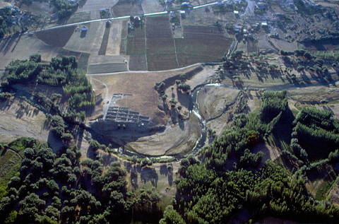
| Location: This site is approximately 25 km southeast of the city of Aksaray; in the district of the Gülagaç municipality within the village of Kizilkaya in the Aksaray province. It lies approximately 1.5 km south of the village. |
| Geography and Environment: The site of Asikli lies in the Cappadocia Region; in the low volcanic area surrounded by the Mount Hasan and the Melendiz Mountain Chains; in the northern extensions of the Ihlara Valley and along Melendiz Stream. The mound measures 230 m east-west and 150 m north-south and is 15.35 m high in the northwest. The south of the mound is 13.16 m high and 8.22 m above the level of the road. The highest point of the mound is at an altitude of 1;119 m. The western part of the mound has been eroded by the Melendiz Stream. |
| Destruction Details: |