|
©The Archaeological Settlements of Turkey - TAY Project
|
|
|
|
|
|
Asikli Höyük |
|
|
For site maps and drawings please click on the picture... 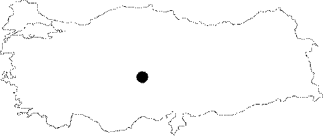 |
For photographs please click on the photo... 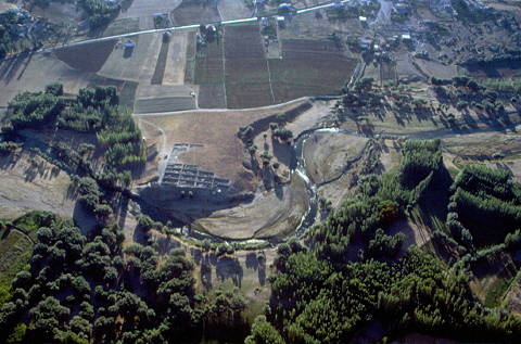 |
|
Type:
|
Mound |
|
Altitude:
|
1145 m |
|
Region:
|
Central Anatolia |
|
Province:
|
Aksaray |
|
District:
|
Gülagaç |
|
Village:
|
Kizilkaya |
|
Investigation Method:
|
Excavation |
|
Period:
|
Aceramic |
|
|
|
 |
|
| Location: This site is approximately 25 km southeast of the city of Aksaray; in the district of the Gülagaç municipality within the village of Kizilkaya in the Aksaray province. It lies approximately 1.5 km south of the village. |
| Geography and Environment: The site of Asikli lies in the Cappadocia Region; in the low volcanic area surrounded by the Mount Hasan and the Melendiz Mountain Chains; in the northern extensions of the Ihlara Valley and along Melendiz Stream. The mound measures 230 m east-west and 150 m north-south and is 15.35 m high in the northwest. The south of the mound is 13.16 m high and 8.22 m above the level of the road. The highest point of the mound is at an altitude of 1;119 m. The western part of the mound has been eroded by the Melendiz Stream. |
| History: |
| Research and Excavation: Asikli Höyük was discovered by E. Gordon in 1963 and was surveyed by I. Todd in 1964 [Todd 1966a:139-163]. Because the mound risked being partly damaged by the rising water levels as a result of the Mamasun Dam built on the Melendiz Stream; salvage excavations were begun in 1989 under the leadership of U. Esin of the University of Istanbul; Faculty of Letters; Prehistory Section [Esin 1991:3; 1996a:31-42]. Excavations are currently continuing. was carried on within this context until 2000. Between 2001-2003, a research that was lead by N. Balkan-Atli was carried out in order to understand the earliest layers at the Deep Trench. Beginning from 2006, a new period of research has started with the direction of M. Özbasaran. The research still continues [Birçek- Özbasaran 2011:32]. |
| Stratigraphy: Excavations; which began at Asikli Höyük in 1989 have revealed that there is one cultural material period at this mound; which dates to the Aceramic Neolithic Period. Excavations so far have identified three phases. The first phase; immediately beneath the soil; is a layer with deteriorated surfaces; many pits and trenches. The main phase of settlement; Phase 2 on the other hand; is comprised of 10 occupational sub-phases. The third phase; which was uncovered in a stepped trench with three occupational phases in the northern side of the mound; is also dated to the Aceramic Neolithic [Esin-Harmankaya 1997: 2]. Phase 4 was also reached in the same area and the excavations are still being continued here [Esin 2002: 83]. Some finds found in the 1.5 m thick alluvial deposit south of the mound; appear to be the oldest finds from the site of Asikli yet found. According to the data from 2012, Layer 4 dating to 9th millennium BC., is the living area of the first inhabitants of Asikli Höyük [Kurt- Özbasaran 2013:24]. |
| Small Finds: Architecture: According to the 1996 site report for the currently continuing Asikli Höyük excavations; there are two layers constituting the Aceramic Neolithic occupation [Esin 1996a:35-39; Esin et al. 1991:136]. The architecture consists of residential mudbrick houses without stone foundations; other structures with specialized functions and neighboring abodes. The eastern part of the settlement is marked by an enclosing wall. The houses built against this wall are mudbrick with stone foundations and are characteristically different than the other structures. Their functions have not been determined as their excavation is not complete. The structures at Asikli underwent little change in terms of location: after a mudbrick house is abandoned; for example; the collapsed mudbricks are used to make an even surface while the old walls are used as a foundation for the new ones. Residential houses; which are clustered on either side (north and southeast) of the main 2 m wide road (labeled GA) are separated by narrow alleyways. The alleys lead to central courtyards used as workshops or garbage areas. The residential houses; which are rectangular structures comprised of one to three rooms; are made solely of mudbrick without stone foundations. Some examples of houses with a rectangular and a rounded side also exist. These structures lack external doors/entrances although the multi-room houses do have intramural doors between the different rooms. It is thus concluded that the entrances to these houses were through the roof. The floors and walls of the houses are plastered. Hearths; which are the most common element within these structures; especially one-roomed houses; are usually placed in the corner of the rooms. They are mostly rectangular in shape; outlined by vertical stone slabs around the outer edges and filled with small pebbles. Although rare; terraces; work-areas marked by thin; low mudbrick walls; round partitions separated by mudbrick walls and post holes are among some of the interior building elements [Esin 1996a: 36; Esin et al. 1991: 136-145]. In the section south of the residential houses where structures with specialized functions are located; stone foundations are common. These structures appear to be clustered around two central courtyard areas. The northern building complex HV lies adjacent to the 2 m wide pebbled road. The wall of this complex facing the road is a thick mudbrick wall made of six rows of mudbrick. Behind this wall are four small rooms [Esin 1993:127]. The walls and floor have been plastered several times with care. Further south; among the buildings in area T; which faces open country; is a square structure with a red painted floor in the western part of the area. With the exception of the collapsed eastern enclosing wall; area T with its red and yellow painted floors has been well preserved. There are some pits; which may have been used as sacrificial areas; and hearths within these structures. West of the area is a monumental kilning while there are one or two roomed structures with carefully plastered walls and floors to the southwest [Esin 1994: 30-31]. As excavations continue; the purpose of the enclosing walls southwest of the structures with special functions might be understood and much about this Aceramic Neolithic settlement will be clarified. The settlement south of the mound; partially exposed by Melendiz Stream; is not very different in terms of structural building elements and finds from Phase 2 of Asikli Höyük. The settlement appears to have been destroyed by a flood [Esin 1996a: 35-36]. In Phase 4 that was reached in the stepped trench to the north of the mound; some differences in the settlement pattern were encountered together with the usage of mudbrick seen in he other phases. Based on the results of the previous studies conducted in Asikli, it has been already known that the settlement consists of clustered mudbrick houses and these houses were separated by narrow streets. The structures defined as "House" show similarity in terms of their size, form and interior building units. This similarity can also be traced in the renewal phases of the superimposed buildings. Besides, it has been known that before the houses were renewed, the mobile elements inside were taken or it was cleaned in one sense and then the houses were renewed. Taking the finds from the buildings, filling inside of the spaces by truncating the floors of the buildings up to 1 m high and sitting the new building on this level were the most important reasons to make it hard to understand the usage of the building and the activities within the buildings. Especially in one of 8 buildings (Building 7) which were excavated in the 2001 campaign, in situ finds which gave us a clue to understand these issues were exposed [Uzdurum-Özbasaran 2012:19-20]. Building 7 has two rooms and it covers an area of 15 square meters. This building had one room in its earlier phase and a second room was added in the renewal phase. The floors and walls were plastered at least two or three times. The floors of the hearths are covered with small pebbles. The western room of the building contains finds which indicate cooking/heating activities as well as different activities. There is a mudbrick bench in N-S direction which leans on its south wall. It has been seen that the hearth was converted into a bench for different purposes [Uzdurum-Özbasaran 2012:20]. The studies carried out in 2012-2013 show that the first inhabitants of Asikli built their houses around an open space. These buildings were exposed in the northern section of the mound. They are semi-subterranean and sub-oval in form. The average diameter of these buildings is 4 m. The walls of the deeply dug pits (about 1.5 m in height) were built with mudbrick blocks that are sun-dried, rectangular and of various sizes. The oval buildings were built, using long rectangular blocks by the superposition technique. The walls and floors are plastered. In one well-preserved semi-oval building, Building 3 (Level 4), pots holes supporting the roof were found on the floor. In a later building belonging to Level 3, four post holes were exposed on the east half of the building. These holes were regularly spaced on the floor and close to the wall. On the plastered floor and the floor fill of this building, two separate groups of collapsed beams were unearthed. The northern group consists of four or five beams, while the southern group has two. These beams are covered with phytoliths and the macroscopic analysis show that these were reeds. The features and finds found inside the buildings indicate some indoor activities. In Building 3, a plastered quadrangular platform, three pits and a central fireplace were exposed at the floor level. No significant archaeological material was found in these pits with a diameter of 35-40 cm. A rounded fireplace was found in the center of the room. This fireplace differs from the typical hearth of the 8th millennium BC in terms of form and location. õn another building (Building 1), slightly later stratigraphically, a similar hearth was found. The hearth is paved with cobbles and lined with mudbrick kerbs. A thick layer of ash and charcoal was found on these cobbles. An oval mudbrick basin, a small basket placed upside down, a finely worked bone spatula and two ground stone tools were recovered from the west of the inner space. These artifacts show the existence of a work or activity area within the building. The contents and condition of this in situ assemblage suggests the sudden abandonment of the building. The open areas outside the buildings are intensively and collectively used work areas. Some of these areas have plastered surfaces or are surrounded by post holes. One of the well-defined work areas is in regular round shape and it measures about 4 m in diameter. It was used regularly as a work area and its surface was continuously plastered. On one of its floors, four post holes were determined. The area was probably covered with a light organic shelter or semi-enclosed. The study on worked bones and obsidian tools indicates that it was used as a multifunction area. Use-wear analysis on obsidian tools shows that skin working, the preparation of vegetal material and cutting soft material occurred in this area. Other parts of the external open spaces were used for various activities as well. Fires and cooking took place either directly on the ground or in roasting pits [Özbasaran-Duru 2015]. Clay Finds: Examples of baked-clay and half baked clay figurines and cones comprise the clay artifacts from Asikli [Esin 1994b: 32][Esin-Harmankaya 1997: 2][Esin et al. 1991: 134]. On the floor of the oval/circular shaped building exposed in Level 4, an oval shaped unbaked clay slab was found near the west wall in the 2012 campaign. After it was molded, this slab was filled with clay and converted into a platform-like feature [Kurt-Özbasaran 2013:24]. Chipped Stone: All of the chipped stone finds are made of obsidian. Asikli has a large selection of a variety of types of chipped stone artifacts. Raw material was brought in large blocks/chunks and worked at the site. The fact that local chipped stone workshops were at the site is important because all the various stages of tool production are thus represented [Balkan-Atli 1993a: 213; 217]. The obsidian technology at Asikli is a blade industry. The number of blade and blade cores greatly exceed the number of flake and flake cores; cores have opposed striking platforms; retouched pieces are mostly scrapers; other tool types include retouched blades; retouched flakes; pointed blades; points; microliths; borers and perforators [Balkan-Atli 1993a: 215-216; 1994a: 209-221][Esin 1994b: 31][Esin et al. 1991: 145-149]. Microliths become more common in the Phase 4 of Asikli Höyük; on the other hand the dimensions of the tools become smaller. It was discovered that the flooring of small pebbles of the hearth which was found in 2011 and converted into a bench afterwards was used for the purpose of obsidian knapping. Obsidian cores, the blades belonging to the same cores and a lot of knapping debitage spread around indicate that this area was left as it was [Uzdurum-Özbasaran 2012:20]. Ground Stone: In addition to celts; sling stones; whetstones and various stone beads; many mortars and pestles; upper and lower grinding stones and a few cooking braziers were found [Esin 1991: 8; 1994b: 32][Esin et al. 1991: 133]. In Building 7 which was exposed in 2011, a ground stone on the bench, a grinding stone on the floor on the east of the bench, a lot of natural and worked stone tools concentrated in the middle of the room were found [Uzdurum-Özbasaran 2012:20]. Bone/Antler: Asikli inhabitants; who obtained much of their food through hunting; also made use of animal bones in many ways. Many bone awls; spatulas; fish-hook-like bone tools; clips; buckles; beads from animal (deer) teeth and antlers were found [Esin 1991: 9] [Esin et al. 1991: 134]. Metal Finds: Analysis of some copper beads from a burial showed that annealing was applied in addition to cold hammering. This sheds light on the early use of copper and malachite and indicates that the inhabitants of Asikli used "pyro-technology" [Esin 1995a61; Esin: in press]. Human Remains: The burial of the dead at Asikli is intramural. They have been placed into pits in the floors of the houses mostly in flexed position although there are examples of burials with the legs extended back. Floors have been replastered after the burial activities. Some of the better preserved skeletons appear to have been burned while others have been covered in straw matting [Özbek 1993a: 206]. While most of the burials of men; women; children; babies and fetuses are single burials; double burials occasionally appear. Of the analyzed skeletons; it has been determined that two of the males are of Mediterranean race. There is evidence of brain surgery (trephination) conducted on one female while another appears to have undergone autopsy. The average life-span for the inhabitants of Asikli is 34.4 years: males' life-spans vary between 18-19; 35-39 or 55-57; and females' are between 20-25 [Esin 1991: 7-8] [Esin et al. 1991: 131-132] [Özbek 1992: 153-154; 1993a: 201]. In the 2012 campaign, a skeleton of about 10-year- old juvenile was found on the hearth in the center of the oval/circular building exposed in Level 4. Due to not being buried in a pit and in hocker position, the burial technique of this skeleton differs from the tradition of mortuary practice seen on the levels of Asikli. In the same building, another skeleton was found in a pit dug into the floor. On the contrary of the above-mentioned skeleton, this one is buried in traditional way, hocker position. Traces of basket/mat were encountered on the skull. In the oval building with rounded corners which was exposed during the studies on the western slope, a skeleton buried in full hocker position was also found in a pit dug into the floor. There are traces of mat on the skeleton and it is thought that the skeleton belong to an adult male [Kurt-Özbasaran 2013:25]. Fauna: All the faunal remains recovered from Asikli are from wild animals. Animal bones are mostly concentrated between the houses in the narrow alley-ways; which were used as trash dumps. The fact that heads and hooves of animals are less frequently found indicates that the initial butchering was conducted at the hunting site. Sheep and goat remains are abundant; but cattle; wild-pig and hare remains are also present. Horse was among the faunal assemblage indicating that horses were living in the Asikli vicinity around 9.000 B.P. [Buitenhuis 1996: 417; fig.4; Buitenhuis: in press][Esin 1994b: 33]. The distribution of skeletal parts shows that almost all the body parts were represented on the mound. This indicates that some of the animals were slaughtered on site or nearby. However, the bones of the lowermost limbs of some of the animals are under represented and this suggests that some of the body parts were discarded before the meat was carried into the residential areas [Özbasaran-Duru 2015]. Flora: The fact that there are faunal remains of domesticated species indicates that in addition to hunting; the Asikli inhabitants supplied part of their subsistence by cultivating plants. These species include Einkorn (Triticum monococcum); Emmer wheat (Triticum dicoccum); durum wheat (Triticum durum); barley (Hordeum distichum); vetch (Vicia ervilia); lentils (Lens culinaris); peas (Pisum satuvim). Almond; pistachio nuts; berry of terebinth; and various grasses were also widely abundant [van Zeist-de Roller 1995: 181-184]. The recent archaeobotanical studies show that emmer and einkorn wheat were the two main domesticated cereals during the 9th millennium BC settlement. The remains of wheat and barley rachis internodes are much more numerous than the grains and it suggests that the harvesting was managed either within the settlement or adjacent to the site. Among the legumes, bitter vetch (Vicia ervilia) is abundant. Lentil (Lens orientalis/culinaris), pea (Pisum sativum) and a few chickpeas are among the consumed cultivated plants. Wild plants and weeds are gathered as well. These are wetland plants such as Carex, Eleocharis and Scirpus maritimus were used in basket and mat making [Özbasaran-Duru 2015]. |
| Remains: |
| Interpretation and Dating: Both 14C dates and Todd and Esin's research confirm that Asikli Höyük is a large Aceramic Neolithic central Anatolian settlement dating to 10;000/9;000 BP [Todd 1968b:157; 1980:149; Esin 1995b:144-146]. Agriculture; hunting; leather working; obsidian knapping; bone and antler working and most probably trade were practiced by the inhabitants of Asikli. The site situates in a geographically advantageous area in respect of its location, which is ecologically diverse. The proximity of Göllüdag and Nenezi volcanic mountains has provided easy access to the raw material resources. It is well known that the animals living in their natural habitat zones around Melendiz Valley were hunted, and variety of plants, nuts and cereals were widely consumed. In Asikli, agriculture and domestication of animals didn't play a primary role. The research is still carried out in order to clarify the reason of this situation by considering not only the convenience provided by the ecological diversity but also the socio-cultural pattern of the site [Birçek- Özbasaran 2010:32]. In the light of the gathered data, Asikli Höyük can be socially and economically defined as a transitional community. These people who maintain the habits of the "old", kept on to the hunter-gatherer subsistence strategy even though they had the knowledge and experience of agriculture. "Domestication" appears to be a phenomenon which hasn't been yet well settled into the different aspects of the community or hasn't been yet totally accepted. It is clear that in order to achieve activities such as hunting, constructing buildings, lime burning and constructing monumental street, communal labor is essential. The uniformity of the buildings in the dwelling area, and the lack of units such as storage facilities indicating individual usage, reveal that this community has a homogenous structure and act in unison. In this respect it is possible to define the social structure of Asikli community as egalitarian/communal. Perhaps the limited number of skeletons which have been treated specially can be considered as an indicator of this social structure becoming more complex. The absence of the symbols at Asikli reflecting the world of belief, the limited external relationships during approximately 1000 years of occupation, standing away from the magnificent symbolic movements of its period and sustaining their own life style at least through 25 generations suggest that the inhabitants possess a motivation except the classic meaning of belief/religion. According to the existing data it can be suggested that in Asikli this motivation corresponds to the communal lifestyle [Birçek- Özbasaran 2010:34]. According to the conclusions of the 2012 campaign, the subsistence economy of Asikli community was based on hunting, gathering and farming. Crops and the wild and domesticated legumes were consumed together. The most common consumed legumes are lentil and black pea. Also, the fruits such as celtis, almond and peanut were gathered and consumed intensively. Sheep and goat are the most common consumed animals. Wild cattle, boar, wild horse, wild ass and red fox were also consumed. Rabbits were hunted intensively. Obsidian was the only raw material in the chipped stone industry and it is known that it was brought from Göllüdag and Nenezi. The tools belonging to the level of 9th millennium BC. consist of bladelets. The tools were made on the flakes, scrapers, borers, burins, various microliths and geometric microliths as well as bladelets with diagonally cut ends show the variety in chipped stone industry [Kurt-Özbasaran 2013:25]. |