| ©The Archaeological Settlements of Turkey - TAY Project | ||||||
|
|
||||||
Sapmaz Köy |
||||||
|
|
||||||
| Ages | Maps | Photos | ||||
| Neolithic Chalcolithic |
 |
 |
||||
|
|
||||||
|
Type:
|
Mound | |||||
|
Altitude:
|
1020 m | |||||
|
Diameter:
|
293 m- Direction: NE-SW | |||||
|
|
||||||
|
Region:
|
Central Anatolia | |||||
|
Province:
|
Aksaray | |||||
|
District:
|
Merkez | |||||
|
Village:
|
Sapmaz | |||||
|
|
||||||
|
Destruction :
|
Agriculture | |||||
|
|
||||||
|
TAYEx:
|
Visited - 4/8/2002 | |||||
|
|
||||||
|
Registration State:
|
For detailed registration information please refer to Turkish pages. | |||||
 |
||||||
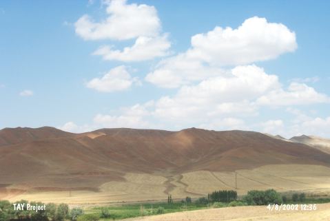
| Location: This site lies 22 km northwest of the city of Aksaray; approximately 1 km southwest of the village of Sapmaz; on the northwestern side of road that leads to the village from the Aksaray-Antalya highway. The other name of the mound is Yassiören. In Omura's publication; the site is referred to as Yassiören [Omura 1991:71]. |
| Geography and Environment: The Sapmaz Köy Mound is approximately 3-4 m high and has a 250 m diameter. It lies on the flanks of the mountains east of the Salt Lake. There is a small stream that flows by. The mound is approximately 150-200 m higher than the Salt Lake water level. |
| Destruction Details: The mound is being damaged due to agricultural activities [TAYEx 4.8.2002]. |