|
©The Archaeological Settlements of Turkey - TAY Project
|
|
|
|
|
|
Sapmaz Köy |
|
|
For site maps and drawings please click on the picture...  |
For photographs please click on the photo... 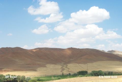 |
|
Type:
|
Mound |
|
Altitude:
|
1020 m |
|
Region:
|
Central Anatolia |
|
Province:
|
Aksaray |
|
District:
|
Merkez |
|
Village:
|
Sapmaz |
|
Investigation Method:
|
Survey |
|
Period:
|
|
|
|
|
 |
|
| The mound; known also by the names of Yassiören and Yastören; lies 22 km northwest of Aksaray; approximately 1 km southwest of Sapmaz Köy. It is discovered in 1965 by I.A. Todd and then surveyed again in 1989 by the Japanese team conducted by S. Omura. Existence of Chalcolithic Age pottery finds; besides the Late Neolithic Age finds known earlier [Harmankaya et al. 1997:Sapmaz Köy]; is declared by Omura. Several incised sherds from the mound display similarities with those from Yüksek Kilise/Gelveri Höyügü. |
| Location: This site lies 22 km northwest of the city of Aksaray; approximately 1 km southwest of the village of Sapmaz; on the northwestern side of road that leads to the village from the Aksaray-Antalya highway. The other name of the mound is Yassiören. In Omura's publication; the site is referred to as Yassiören [Omura 1991:71]. |
| Geography and Environment: The Sapmaz Köy Mound is approximately 3-4 m high and has a 250 m diameter. It lies on the flanks of the mountains east of the Salt Lake. There is a small stream that flows by. The mound is approximately 150-200 m higher than the Salt Lake water level. |
| History: |
| Research and Excavation: |
| Stratigraphy: |
| Small Finds: |
| Remains: |
| Interpretation and Dating: |