| ©The Archaeological Settlements of Turkey - TAY Project | ||||||
|
|
||||||
Pulur |
||||||
|
|
||||||
| Ages | Maps | Photos | ||||
| Chalcolithic EBA IA |
 |
 |
||||
|
|
||||||
|
Type:
|
Mound | |||||
|
Altitude:
|
1800 m | |||||
|
Diameter:
|
m- Direction: | |||||
|
|
||||||
|
Region:
|
Eastern Anatolia | |||||
|
Province:
|
Erzurum | |||||
|
District:
|
Ilica | |||||
|
Village:
|
Ömertepe | |||||
|
|
||||||
|
Destruction :
|
Contemporary Settlements - Attention | |||||
|
|
||||||
|
TAYEx:
|
Visited - 27/6/2003 | |||||
|
|
||||||
|
Registration State:
|
Registered For detailed registration information please refer to Turkish pages. | |||||
 |
||||||
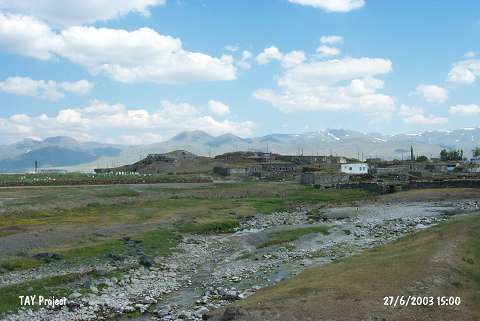
| Location: It is located in the village of Pulur (Ömertepe); 7-8 km south-southeast of the Ilica District; 15 km west-southwest of Erzurum Province. |
| Geography and Environment: Adjacent to the mound; the Pulur Stream flows about 17 m high above the Erzurum Plain. It is surrounded by a fertile land. Although no information was provided about the dimensions of the mound; the drawing [Kosay-Vary 1964:pl.II-III] and the photographs indicate that it is not a big mound. The publications reveal that it has been severely damaged by the villagers as a result of removal of stone and earth. |
| Destruction Details: The settlement has been severely destructed. Village houses were built on its slopes and skirts except for the northern skirt. The mound has been cut by a deep cleft in the southwest-northeast axis [TAYEx 27.6.2003]. |