|
©The Archaeological Settlements of Turkey - TAY Project
|
|
|
|
|
|
Pulur |
|
|
For site maps and drawings please click on the picture... 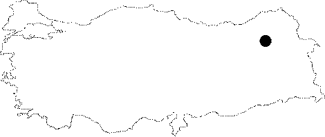 |
For photographs please click on the photo... 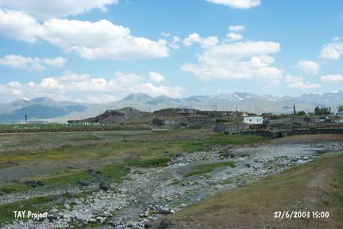 |
|
Type:
|
Mound |
|
Altitude:
|
1800 m |
|
Region:
|
Eastern Anatolia |
|
Province:
|
Erzurum |
|
District:
|
Ilica |
|
Village:
|
Ömertepe |
|
Investigation Method:
|
Excavation |
|
Period:
|
EBA III |
|
|
|
 |
|
| Location: It is located in the village of Pulur (Ömertepe); 7-8 km south-southeast of the Ilica District; 15 km west-southwest of Erzurum Province. |
| Geography and Environment: Adjacent to the mound; the Pulur Stream flows about 17 m high above the Erzurum Plain. It is surrounded by a fertile land. Although no information was provided about the dimensions of the mound; the drawing [Kosay-Vary 1964:pl.II-III] and the photographs indicate that it is not a big mound. The publications reveal that it has been severely damaged by the villagers as a result of removal of stone and earth. |
| History: |
| Research and Excavation: The site is excavated in 1960 by H.Z. Kosay and H. Vary on behalf of Erzurum Atatürk University. The excavations have been conducted at the westerns skirts; on the mound and at the eastern skirts. Virgin soil has been met. It takes place in the registered archaeological sites list prepared by Ministry of Culture and Tourism. |
| Stratigraphy: A good stratification was not obtained since the excavation was lasted for a short period of time. The trench on the western slope which was preferred since it was economical to excavate a wider area yielded four architectural remains. The virgin soil was reached at 17 m depth from the surface level. The eastern trench yielded a cemetery dated to a later period than EBA while the trench opened on the top has laid out two upper building levels dated to the Seljuk Period. The upper one is assumed to be a principal's house. The sterile deposit of 6 m thick underneath followed by a 2-3 m thick stone piles was not clarified. Very restricted number of EBA sherds was recovered from this sterile deposit. Even tough there was a possibility of forming a tumulus on the uphill after the bronze age by removing the cultural deposit of EBA in the foothill and stuffing stones instead; no chamber room was uncovered during the excavation. Under the stone piles; the trench on the western slope yielded the level 2 which underwent a massive fire [Kosay-Vary 1964:24-25]. |
| Small Finds: Architecture: All the levels of the mound are dated to the Late Chalcolithic Age by the excavators. However; the upper levels of the Late Chalcolithic Age settlements can; probably; be dated to the third millennium BC depending on the finds. Kosay and Vary identify the period as Chalcolithic Age and the beginning of the settlement as 2600 BC. The schematic plan provided in a publication that can be accepted as the final excavation report illustrates some uncovered parts of four-cornered structures with thin and thick walls [Kosay-Vary 1964:9]. These are as follows from upper to lower levels: The building level 1 yielded destroyed remains belonging to a settlement; underwent a fire; with mudbrick buildings. Some of the rooms have stone floors. The building level 2 yielded only up to a three rows portion of the stone walls of a structure; 6.0 x 6.6 m in dimensions. Series of stones and hearths were uncovered in the building level 3. Pottery: Presence of Karaz ware is reported in the building levels 1-4 by the researchers. Sherds probably dating to the Late Chalcolithic Age of Central Anatolia from the level 4 recovered from the western trench expose that the upper levels (1-3); except this level; can be possibly dated to EBA. Handmade; red and black colored ware is decorated with relief bands and grooves/excisions. The paste is grit tempered. The relief decorated samples lessen through the lower levels. Also found are incision decorated samples. As decorations; bird and animal figures in abstract forms; zigzag patterns; etc. can be seen. The forms of bowl; cup; mug; plate; jug; cooking pot and storage jar are common. Also found are functional items like lids; sieves and saltcellars. The vessels are largely burnished [Kosay-Vary 1964:15-18]. Clay: Movable hearth stands presumed to have a cult meaning; various forms of idols and figurines were recovered. Types of the idols are distinctive from the Central Anatolian types. Chipped Stone: There is an industry of obsidian. The obsidian cores are said to be brought from the slopes of the mountains to the west of Pulur. Flintstone is almost absent. The scale technique was applied in flaking. Some of the objects like blade; scraper; saw; spearhead; disc and borer were chipped from crystal-clear obsidian in various colors [Kosay-Vary 1964:19-20]. Ground Stone: Flat and shaft-holed in dark green nephritis were found in mass in one level; and rare in the others. Also found are objects like mortar and hammer; and stones burnished because of the rubbing since they were used as polishing stones. Pierced stones indicate the extent the weaving industry is employed. The grinding stones show were also found. Bone/Antler: Samples of bone industry include awls made of joint bones of sheep and goats by cutting and sharpening the end without touching the joint; denticulated combs and pierced pins. Metal: A sickle having charred grains of wheat on it; a flat axe and a flat chisel were found in such amounts that the metallic finds is quite few for Pulur compared to the area excavated. It is unknown if these are in copper or bronze as no analysis was performed. |
| Remains: |
| Interpretation and Dating: The stratification and dating of Karaz; Pulur and Güzelova settlements are not definite yet. A. Sagona reports that the pottery recovered from the earlier layers of Karaz was not found at Pulur and therefore; Pulur can; probably; be dated to EBA III-MBA II depending on the material recovered and publications on Pulur [Sagona 2000:table at fig 5]. It is suggested that Pulur has a compressed settlement plan. It is uncertain if these villages were fortified. The houses have stone socles; mantle bases; mudbrick walls and flat rooms conforming to the today's architecture of Eastern Anatolia. The circular hearths inside the houses are thought to play an important role in their daily life. The decorated hearth stands; claimed to have a sacred meaning; are believed to be placed under the cooking pots. The grinding stones indicate the presence of a nutrition economy largely based on wheat-barley integrated by hunting. God and goddess idols in terra cotta represent the religious beliefs of the inhabitants. Awls and needles in bone might have been utilized for sewing coarse-woven cloths; bags and leather accessories; and the 3-5 denticulate bone combs for weaving rugs. |