| ©The Archaeological Settlements of Turkey - TAY Project | ||||||
|
|
||||||
Minareli / Tilwa Höyük |
||||||
|
|
||||||
| Ages | Maps | Photos | ||||
| Chalcolithic EBA IA |
 |
 |
||||
|
|
||||||
|
Type:
|
Mound | |||||
|
Altitude:
|
90 m | |||||
|
Diameter:
|
m- Direction: | |||||
|
|
||||||
|
Region:
|
Mediterranean | |||||
|
Province:
|
Osmaniye | |||||
|
District:
|
Toprakkale | |||||
|
Village:
|
Aslanpinari | |||||
|
|
||||||
|
Destruction :
|
Illicit Digging - Agriculture | |||||
|
|
||||||
|
TAYEx:
|
Visited - 31/7/2001 | |||||
|
|
||||||
|
Registration State:
|
For detailed registration information please refer to Turkish pages. | |||||
 |
||||||
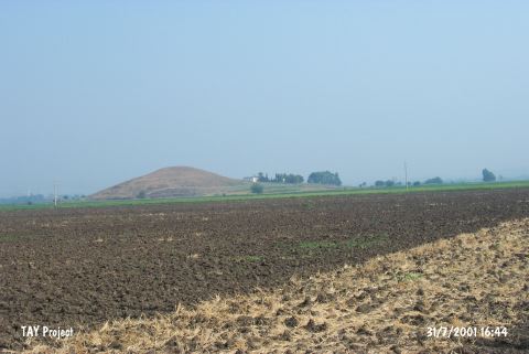
| Location: |
| Geography and Environment: |
| Destruction Details: The mound has been damaged due to agricultural activities and illicit diggings. The eastern skirt has been partly disturbed by the road. The northeast skirt is planted; western part is terraced and east and southeast skirts are leveled. There pits on western slope [TAYEx 31.7.2001]. |