| ©The Archaeological Settlements of Turkey - TAY Project | ||||||
|
|
||||||
Kumluktepe |
||||||
|
|
||||||
| Ages | Maps | Photos | ||||
| Neolithic |
 |
 |
||||
|
|
||||||
|
Type:
|
Mound | |||||
|
Altitude:
|
1100 m | |||||
|
Diameter:
|
40 m- Direction: NE-SW | |||||
|
|
||||||
|
Region:
|
Central Anatolia | |||||
|
Province:
|
Kayseri | |||||
|
District:
|
Incesu | |||||
|
Village:
|
Merkez | |||||
|
|
||||||
|
Destruction :
|
Illicit Digging - Agriculture - Attention | |||||
|
|
||||||
|
TAYEx:
|
Visited - 26/7/2002 | |||||
|
|
||||||
|
Registration State:
|
Registered For detailed registration information please refer to Turkish pages. | |||||
 |
||||||
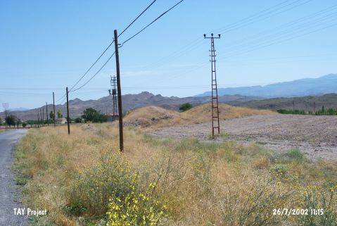
| Location: This site lies southwest of the city of Kayseri; along the Kayseri-Nigde train tracks; approximately 250 m south of the Incesu Train Station; immediately west of the train tracks. The mound is located 1.5 km northeast of the town center. It is possible to get to Kumluktepe by taking the Nevsehir-Ürgüp-Incesu highway and taking the turnoff to the train station. |
| Geography and Environment: According to Todd; the mound is 5 m high and has a 150 m base diameter. This researcher noted that the mound had been damaged by villagers who had dug pits and trenches on the mound. It is clear that one of these village excavations found a large late-period burial chamber. The spoil generated during the looting was spread around the surface of the mound. The mound is in a large valley between the Yesilhisar and Kayseri Plains. There is another mound known as Hacafer Tepesi; north of the train station. In some publications this site is called Incesu or Kumtepe instead of Kumluktepe. Mellaart preferred to call the site Kumtepe-Incesu. There are freshwater springs nearby. |
| Destruction Details: The mound has been seriously damaged due to illicit diggings and agricultural activities. Top hill has been excavated in east-west direction and northern slope has been cultivated [TAYEx 26.7.2002]. |