|
©The Archaeological Settlements of Turkey - TAY Project
|
|
|
|
|
|
Kumluktepe |
|
|
For site maps and drawings please click on the picture...  |
For photographs please click on the photo... 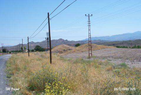 |
|
Type:
|
Mound |
|
Altitude:
|
1100 m |
|
Region:
|
Central Anatolia |
|
Province:
|
Kayseri |
|
District:
|
Incesu |
|
Village:
|
Merkez |
|
Investigation Method:
|
Survey |
|
Period:
|
Ceramic |
|
|
|
 |
|
| Location: This site lies southwest of the city of Kayseri; along the Kayseri-Nigde train tracks; approximately 250 m south of the Incesu Train Station; immediately west of the train tracks. The mound is located 1.5 km northeast of the town center. It is possible to get to Kumluktepe by taking the Nevsehir-Ürgüp-Incesu highway and taking the turnoff to the train station. |
| Geography and Environment: According to Todd; the mound is 5 m high and has a 150 m base diameter. This researcher noted that the mound had been damaged by villagers who had dug pits and trenches on the mound. It is clear that one of these village excavations found a large late-period burial chamber. The spoil generated during the looting was spread around the surface of the mound. The mound is in a large valley between the Yesilhisar and Kayseri Plains. There is another mound known as Hacafer Tepesi; north of the train station. In some publications this site is called Incesu or Kumtepe instead of Kumluktepe. Mellaart preferred to call the site Kumtepe-Incesu. There are freshwater springs nearby. |
| History: |
| Research and Excavation: The site was discovered in 1963 by G. Pasquare and researched in 1964 and 1967 by I.A. Todd. It was revisited by the Japanese survey crew under the leadership of S. Omura in 1990. It takes place in the registered archaeological sites list prepared by Ministry of Culture and Tourism. |
| Stratigraphy: In addition to Neolithic pottery; the surface of the mound yielded Early Bronze Age II and later material. |
| Small Finds: Pottery: The analysis of the ceramics assigned to the Neolithic Period allowed to conclude that there were two main ware types. One is the Dark Burnished Ware which is similar to the closed jars and bowls in Çatalhöyük East and the Neolithic ceramics from Yumuktepe. The second pottery type; on the other hand; is coarse ware with a light brown surface color. The second type is less common than the first [Todd 1980:53]. Chipped Stone: A total of 1;925 chipped stone tools were found during Todd's surface survey at the site. Of the total; 1;347 were flakes. 13 tanged retouched points; scrapers; borers; blades and a few cores were also found. The most common raw material appears to be obsidian although a few flint tools were also found. |
| Remains: |
| Interpretation and Dating: Todd believes the site is contemporaneous with Çatalhöyük East [Todd 1980:80-84]. In ASPRO; the site was placed in phase 5. The uncalibrated dates for this phase is 8;000-7;600 BP [Hours et al. 1994:217]. |