| ©The Archaeological Settlements of Turkey - TAY Project | ||||||
|
|
||||||
Adatepe 2 |
||||||
|
|
||||||
| Ages | Maps | Photos | ||||
| Neolithic EBA IA |
 |
 |
||||
|
|
||||||
|
Type:
|
Mound | |||||
|
Altitude:
|
110 m | |||||
|
Diameter:
|
m- Direction: | |||||
|
|
||||||
|
Region:
|
Mediterranean | |||||
|
Province:
|
Adana | |||||
|
District:
|
Ceyhan | |||||
|
Village:
|
Hamdili | |||||
|
|
||||||
|
Destruction :
|
Illicit Digging | |||||
|
|
||||||
|
TAYEx:
|
Visited - 1/8/2001 | |||||
|
|
||||||
|
Registration State:
|
Registered For detailed registration information please refer to Turkish pages. | |||||
 |
||||||
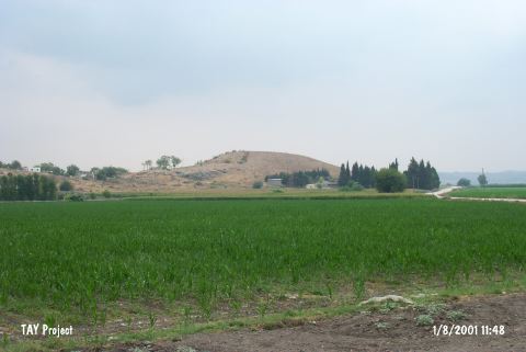
| Location: It is located on a rocky block called Kartalkaya Tepesi; between Adatepe and Hamdili villages; south of the Ceyhan-Osmaniye motorway; 7 km east of Ceyhan District; east of Adana Province. It locates 2.4 km south of Adatepe Village. |
| Geography and Environment: The site is located in the northern Yukari Ova (Upper Plain) section of the Çukurova Plain; which is surrounded by the Bolkar Mountains to the northwest; the Akdaglar Mountains to the north and the Amanos Mountains to the east. The Adatepe mound lies on a natural hill which overlooks the valley that leads to the Kürtkulak Geçidi mountain pass. This medium-sized conical mound is 20 m high. There are ruins on the northern side of the mound which date to a "later"; unidentified period. |
| Destruction Details: The mound has been damaged due to illicit diggings. There are lots of pits on it. Two of them which are the biggest ones measure 7x4 m and 5x3 m. [TAYEx 1.8.2001]. |