|
©The Archaeological Settlements of Turkey - TAY Project
|
|
|
|
|
|
Adatepe 2 |
|
|
For site maps and drawings please click on the picture...  |
For photographs please click on the photo... 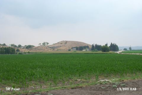 |
|
Type:
|
Mound |
|
Altitude:
|
110 m |
|
Region:
|
Mediterranean |
|
Province:
|
Adana |
|
District:
|
Ceyhan |
|
Village:
|
Hamdili |
|
Investigation Method:
|
Survey |
|
Period:
|
|
|
|
|
 |
|
| It is located between the Hamdili and Adatepe Villages to the south of the Ceyhan-Osmaniye motorway, 7 km east of the Ceyhan District and the provincial center of Adana. It lies on the southern ourcrop of the Kartalkaya Hill, 2.4 km south of the Adatepe Village. With a height of 20 m, it is a large conical hill. It lies on the Upper Plain on the northern part of the Çukurova Plain, which is surrounded by the Bolkar Mountain range to the northwest, the Akdaglar Mountain range to the north and the Amanus Mountain range to the east. It rises on a natural elevation overlooking the valley extending towards the Kurtkulagi Mountain Pass. Some wall remains, probably from later periods, are observed on the north. It was discovered in 1951 during the Cilicia Survey conducted under the direction of M.V. Seton-Williams; and several sherds dating from the Chalcolithic to the Byzantine Ages were collected in addition to the EBA sherds [Seton-Williams 1954:147, findspot no. 62]. The site is only referred to as Adatape. It takes place in the registered archaeological sites list prepared by Ministry of Culture and Tourism. |
| Location: It is located on a rocky block called Kartalkaya Tepesi; between Adatepe and Hamdili villages; south of the Ceyhan-Osmaniye motorway; 7 km east of Ceyhan District; east of Adana Province. It locates 2.4 km south of Adatepe Village. |
| Geography and Environment: The site is located in the northern Yukari Ova (Upper Plain) section of the Çukurova Plain; which is surrounded by the Bolkar Mountains to the northwest; the Akdaglar Mountains to the north and the Amanos Mountains to the east. The Adatepe mound lies on a natural hill which overlooks the valley that leads to the Kürtkulak Geçidi mountain pass. This medium-sized conical mound is 20 m high. There are ruins on the northern side of the mound which date to a "later"; unidentified period. |
| History: |
| Research and Excavation: |
| Stratigraphy: |
| Small Finds: |
| Remains: |
| Interpretation and Dating: |